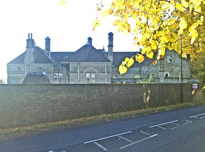
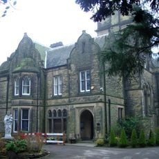
Parkhead Hall, Grade II listed building in Whirlow, Sheffield, England
Parkhead Hall is a two-storey Gothic structure distinguished by carved human heads adorning the eaves and entrance, showcasing Victorian architectural craftsmanship. The dining room retains its original oak paneling, representing the building's interior details from its period.
The building was constructed in 1864 by architect John Brightmore Mitchell-Withers under the original name The Woodlands, then purchased by metallurgist Sir Robert Hadfield in 1898. This acquisition marked a transition to new ownership during Sheffield's industrial expansion era.
The dining room holds wood panels sourced from Sheffield Manor, linking the building to earlier phases of local architectural heritage. This connection shows how older craftsmanship was integrated into Victorian design.
The northern side of the building can be viewed from Ecclesall Road South, though tall walls and surrounding modern housing limit visibility. Visitors should observe from the public road and respect private property boundaries when passing through this residential area.
During World War II, this property served as headquarters for RAF Balloon Command No. 33 until September 1944, connecting it to Sheffield's wartime history. Few visitors realize this residential building once held strategic military importance for air defense operations.
Location: Sheffield
Website: http://bpestates.co.uk/buy/?gref=25674822
GPS coordinates: 53.34496,-1.52233
Latest update: December 12, 2025 16:43
Beauchief Abbey
2 km
Millhouses Park
1.5 km
Shepherd Wheel
2.2 km
Mylnhurst
1.2 km
Whiteley Wood Hall
1.8 km
All Saints Church, Ecclesall
1.5 km
Banner Cross Hall
1.7 km
Chelsea Park
2.1 km
Forge Dam Park
2.2 km
Banner Cross Methodist Church
1.9 km
Hutcliff Wood
1.8 km
Charcoal Burners Memorial In Ecclesall Wood
789 m
Church of St Oswald
2.3 km
Church of Holy Trinity
1.5 km
Monument To Thomas Boulsover On North Side Of Wire Mill Dam
2.1 km
Ecclesall War Memorial
1.4 km
Bents Green House And Attached Boundary Wall
695 m
Abbeydale Works Museum
1.5 km
Sewer Gas Lamp Opposite Junction With Union Road
2.2 km
Beauchief Hall and adjoining Steps, Forecourt Walls and Gates
2 km
War Memorial at Junction with Savage Lane
2.3 km
Church of St Thomas Becket, Beauchief Abbey
1.9 km
Caretakers House At Carter Knowle Junior School
2.2 km
Managers House And Adjoining Stable On East Side Of Abbeydale Works Museum
1.8 km
Milestone, Beauchief Drive, ¼ mile above Beauchied Abbey
2.2 km
Milestone, Beauchief Drive, on bend at entrance to Beauchief Hall
2.2 km
Milestone, Ringinglow Road, outside No. 153
1.3 km
Milestone, Ringinglow Road, opp entrance to Castle Dyke
1.4 kmVisited this place? Tap the stars to rate it and share your experience / photos with the community! Try now! You can cancel it anytime.
Discover hidden gems everywhere you go!
From secret cafés to breathtaking viewpoints, skip the crowded tourist spots and find places that match your style. Our app makes it easy with voice search, smart filtering, route optimization, and insider tips from travelers worldwide. Download now for the complete mobile experience.
A unique approach to discovering new places❞
— Le Figaro
All the places worth exploring❞
— France Info
A tailor-made excursion in just a few clicks❞
— 20 Minutes