Scotswood Railway Bridge, Railway bridge in Scotswood, England
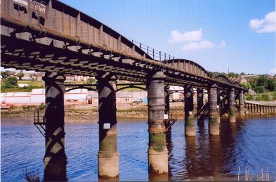
Scotswood Railway Bridge is a railway viaduct crossing the River Tyne, consisting of six sections supported by five massive cast iron cylindrical piers. The structure extends over approximately 212 meters and measures about 7.7 meters in width, with its longest span reaching around 38 meters.
This bridge was completed in 1871 and replaced several earlier structures, including an original wooden bridge from 1839 that was destroyed by hot ash. The new construction marked an important advance in the region's railway infrastructure.
This structure shows the engineering methods of the Victorian railway era through its combination of cast and wrought iron components. Visitors can observe the massive cylindrical piers that support the bridge and reflect the skilled craftsmanship of that period.
The structure is not accessible on foot to the public today, as it remains in railway use and contains private sections. The best views of the bridge can be found from the nearby riverbank or from neighboring bridges in the area.
The bridge was constructed at a calculated angle across the river to avoid sharp curves that would have forced trains to slow down. This thoughtful design allowed for higher speeds across the structure.
Location: Tyne and Wear
Official opening: 1871
Length: 212.6 m
Longest Span: 37.9 m
Width: 7.7 m
Made from material: wrought iron, cast iron
GPS coordinates: 54.96800,-1.69400
Latest update: December 12, 2025 14:27
The Mitre
1.7 km
Scotswood Bridge
279 m
Axwell House
1.8 km
Blaydon Bridge
339 m
Milecastle 7
1.8 km
Milecastle 8
2.1 km
Milecastle 6
2.7 km
Royal Victoria School For The Blind
1.6 km
St Paul's Church
2.8 km
Temple of Antenociticus in New upon Tyne
2.2 km
Church of Holy Saviour, Lemington
1.1 km
Church of St Mary
2.7 km
Church of St Cuthbert
1.3 km
Church of St James
2.1 km
Mather Tomb In St John's Cemetery
2.7 km
Holy Cross Church, Fenham
2.4 km
Benwell Waterworks Chimney
1.1 km
Whickham War Memorial
2.8 km
War Memorial
1.7 km
Roman Turret Opposite Number 800, Bishops House (denton Hall) With Section Of Hadrian's Wall
1.8 km
Vallum crossing at Benwell Fort
2.1 km
Number 4 And Wall Adjoining To North
1.8 km
Lemington Cone
1.6 km
'Derwent Walk Express' and supporting bridge abutment and approach spans
1.7 km
Hadrian's Wall and vallum in wall mile 8 from Denton to Blucher
2.4 km
Former Whickham View Schools
1.1 km
Bishop's House
1.9 km
Summerhouse
2 kmVisited this place? Tap the stars to rate it and share your experience / photos with the community! Try now! You can cancel it anytime.
Discover hidden gems everywhere you go!
From secret cafés to breathtaking viewpoints, skip the crowded tourist spots and find places that match your style. Our app makes it easy with voice search, smart filtering, route optimization, and insider tips from travelers worldwide. Download now for the complete mobile experience.
A unique approach to discovering new places❞
— Le Figaro
All the places worth exploring❞
— France Info
A tailor-made excursion in just a few clicks❞
— 20 Minutes