Enable Location

We need your location to show you interesting places around you

Discover nearby places

Find interesting locations and hidden gems around you

Precise directions

Get accurate directions and distances to places

Your location is never shared with other users. It's only used when you tap the location button.

The Mitre

Log in to your account

Start exploring — it's free

Trusted by 62,551 travelers worldwide

Continue with Google
Continue with Apple
or

We will send you a code to connect

By continuing, you accept our Terms and Conditions and our Privacy Policy

Check your inbox

We've sent a pincode in your inbox. Please enter the code below.

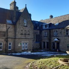
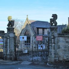
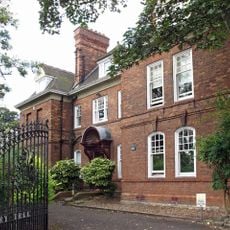
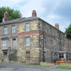
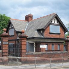
The Mitre, Grade II listed pub in Benwell, Newcastle upon Tyne, England

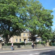
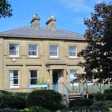
The Mitre is a large stone building in Benwell featuring Gothic architectural elements like pointed arches and decorative stonework across its exterior walls. The structure now serves as home to the Bahr Academy, an Islamic school offering community facilities for the local area.

The building was designed by architect John Dobson in 1831, replacing an earlier medieval structure from the 1200s. It served as a family residence before undergoing several transformations into different uses over the following centuries.

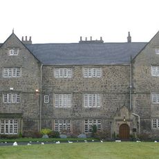
The building gained nationwide recognition as the primary filming location for the BBC children's television series Byker Grove from 1989 to 2006.

The building sits at the junction of Benwell Lane and Ferguson Lane in the western part of Newcastle. Visitors should know that the space functions as a school with community services today, so access may be limited depending on activities taking place inside.

The building served as the primary filming location for the BBC children's series Byker Grove between 1989 and 2006. Young viewers from Newcastle recognized the location as a central part of one of the era's most popular shows.

The community of curious travelers

AroundUs brings together thousands of curated places, local tips, and hidden gems, enriched daily by 60,000 contributors worldwide.

Start exploring
GPS coordinates
54.97454,-1.67081
Latest update
December 9, 2025 18:48
Around this place
Scotswood Bridge
United Kingdom

Scotswood Bridge

1.5 km
Scotswood Railway Bridge
United Kingdom

Scotswood Railway Bridge

1.7 km
Blaydon Bridge
United Kingdom

Blaydon Bridge

1.8 km
Milecastle 7
United Kingdom

Milecastle 7

719 m
St Stephen's Church, Low Elswick
United Kingdom

St Stephen's Church, Low Elswick

2.3 km
Milecastle 8
United Kingdom

Milecastle 8

2.3 km
Milecastle 6
United Kingdom

Milecastle 6

1.1 km
Royal Victoria School For The Blind
United Kingdom

Royal Victoria School For The Blind

227 m
Temple of Antenociticus in New upon Tyne
United Kingdom

Temple of Antenociticus in New upon Tyne

573 m
Church of Holy Saviour, Lemington
United Kingdom

Church of Holy Saviour, Lemington

2.3 km
Church of St Philip
United Kingdom

Church of St Philip

2.4 km
Church of St James and St Basil
United Kingdom

Church of St James and St Basil

1.8 km
Church of St Michael And Presbytery Attached
United Kingdom

Church of St Michael And Presbytery Attached

2.2 km
West Gateway, Walls And Gates Of St Nicholas Cemetery
United Kingdom

West Gateway, Walls And Gates Of St Nicholas Cemetery

1.7 km
Church of St James
United Kingdom

Church of St James

740 m
Church House And Dwarf Walls In Front
United Kingdom

Church House And Dwarf Walls In Front

1.5 km
The Balmoral Public House
United Kingdom

The Balmoral Public House

2.3 km
Mather Tomb In St John's Cemetery
United Kingdom

Mather Tomb In St John's Cemetery

1.5 km
Holy Cross Church, Fenham
United Kingdom

Holy Cross Church, Fenham

977 m
Benwell Waterworks Chimney
United Kingdom

Benwell Waterworks Chimney

520 m
Town Moor Boundary Stone About One Metre North Of Millmount
United Kingdom

Town Moor Boundary Stone About One Metre North Of Millmount

2.1 km
Roman Turret Opposite Number 800, Bishops House (denton Hall) With Section Of Hadrian's Wall
United Kingdom

Roman Turret Opposite Number 800, Bishops House (denton Hall) With Section Of Hadrian's Wall

1.7 km
Clennell Family Tomb In Westgate Hill Cemetery
United Kingdom

Clennell Family Tomb In Westgate Hill Cemetery

2.5 km
Vallum crossing at Benwell Fort
United Kingdom

Vallum crossing at Benwell Fort

418 m
Lodge To South East Of Westgate Hill School, And Wall, Piers, Gateposts And Gates
United Kingdom

Lodge To South East Of Westgate Hill School, And Wall, Piers, Gateposts And Gates

2.1 km
Piers And Walls In Front Of Number 416A
United Kingdom

Piers And Walls In Front Of Number 416A

1.5 km
Newcastle General Hospital Young People's Unit And Dwarf Walls In Front
United Kingdom

Newcastle General Hospital Young People's Unit And Dwarf Walls In Front

1.6 km
Bishop's House
United Kingdom

Bishop's House

1.8 km
Show the full map
« The Mitre - Grade II listed pub in Benwell, Newcastle upon Tyne, England » is provided by Around Us (aroundus.com). Images and texts are derived from Wikimedia project under a Creative Commons license. You are allowed to copy, distribute, and modify copies of this page, under the conditions set by the license, as long as this note is clearly visible.

Discover hidden gems everywhere you go!

From secret cafés to breathtaking viewpoints, skip the crowded tourist spots and find places that match your style. Our app makes it easy with voice search, smart filtering, route optimization, and insider tips from travelers worldwide. Download now for the complete mobile experience.

Around Us App Screenshot

A unique approach to discovering new places

Le Figaro

All the places worth exploring

France Info

A tailor-made excursion in just a few clicks

20 Minutes

Around Us
Travel Guide & Maps
Download

Send to your phone

QR Code
1

Open the camera app on your mobile.

2

Point at the QR code with your camera. A notification will appear.

3

Tap the notification to open the link.