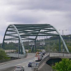
Blaydon Bridge, Box girder bridge in Newcastle upon Tyne, England.
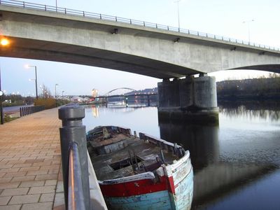
Blaydon Bridge is a road bridge crossing the River Tyne near Newcastle upon Tyne that stretches 332 meters in total length. Its structure relies on prestressed concrete and two concrete piers set in the river to support traffic flow.
This bridge was completed in 1990 as the final section of the Newcastle Western Bypass. Its opening significantly reduced congestion on the Tyne Tunnel by providing an alternative route for regional traffic.
The bridge represents a significant engineering achievement in northern England, connecting the communities of Scotswood in Newcastle and Blaydon in Gateshead.
The structure primarily carries vehicle traffic but also includes paths for cyclists to use. Visitors can view it from various vantage points, especially from the riverbanks, which offer good angles to see the construction details.
The design employs balanced cantilever techniques that allow large spans to be achieved without intermediate supports. This construction method was relatively advanced for British infrastructure projects of that era.
Location: Newcastle upon Tyne
Official opening: December 3, 1990
Length: 332 m
Longest Span: 108 m
Width: 14.6 m
Made from material: prestressed concrete
GPS coordinates: 54.97000,-1.69800
Latest update: December 13, 2025 17:09
The Mitre
1.8 km
Scotswood Bridge
611 m
Scotswood Railway Bridge
339 m
Axwell House
1.9 km
Milecastle 7
1.8 km
Milecastle 9
2.8 km
Milecastle 8
1.8 km
Milecastle 6
2.9 km
Royal Victoria School For The Blind
1.8 km
St Paul's Church
2.8 km
Temple of Antenociticus in New upon Tyne
2.4 km
Church of Holy Saviour, Lemington
780 m
Church of St Cuthbert
1.2 km
Church of St James
2.4 km
Mather Tomb In St John's Cemetery
3 km
Holy Cross Church, Fenham
2.4 km
Benwell Waterworks Chimney
1.3 km
Outer West Library
2.6 km
Roman Turret Opposite Number 800, Bishops House (denton Hall) With Section Of Hadrian's Wall
1.6 km
War Memorial
2 km
Vallum crossing at Benwell Fort
2.2 km
Number 4 And Wall Adjoining To North
1.5 km
Lemington Cone
1.2 km
'Derwent Walk Express' and supporting bridge abutment and approach spans
1.9 km
Hadrian's Wall and vallum in wall mile 8 from Denton to Blucher
2.1 km
Former Whickham View Schools
1 km
Bishop's House
1.7 km
Summerhouse
1.8 kmVisited this place? Tap the stars to rate it and share your experience / photos with the community! Try now! You can cancel it anytime.
Discover hidden gems everywhere you go!
From secret cafés to breathtaking viewpoints, skip the crowded tourist spots and find places that match your style. Our app makes it easy with voice search, smart filtering, route optimization, and insider tips from travelers worldwide. Download now for the complete mobile experience.
A unique approach to discovering new places❞
— Le Figaro
All the places worth exploring❞
— France Info
A tailor-made excursion in just a few clicks❞
— 20 Minutes