Enable Location

We need your location to show you interesting places around you

Discover nearby places

Find interesting locations and hidden gems around you

Precise directions

Get accurate directions and distances to places

Your location is never shared with other users. It's only used when you tap the location button.

St Ursula's School

Log in to your account

Start exploring — it's free

Trusted by 62,119 travelers worldwide

Continue with Google
Continue with Apple
or

We will send you a code to connect

By continuing, you accept our Terms and Conditions and our Privacy Policy

Check your inbox

We've sent a pincode in your inbox. Please enter the code below.

St Ursula's School

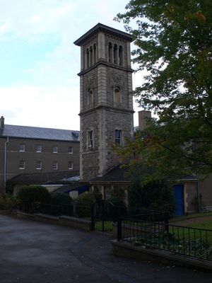
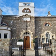
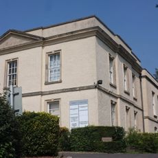
St Ursula's School, Grade II listed primary school in Westbury-on-Trym, Bristol, England.

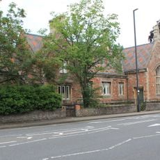
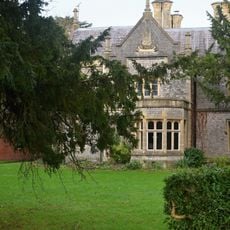
St Ursula's School is a Grade II listed building in Westbury-on-Trym, a stone structure built across multiple floors with distinctive Victorian architecture. The building houses classrooms, specialist rooms, and sports facilities distributed throughout the complex.

The building was founded in 1896 by the Sisters of Mercy and initially served as a girls' boarding school. Following bomb damage during World War II, it was rebuilt in 1948 and later converted to a coeducational primary school.

The school takes its name from Saint Ursula and displays late Victorian design features throughout its interior that reflect educational thinking of that era. Visitors can observe period architectural details in the classrooms and corridors.

The building is located on Brecon Road and is easy to find. Keep in mind that this is an active school, so access to the interior is normally restricted to certain times or requires prior permission.

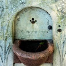
During World War II, the cellars of the building served as air raid shelters for the school and surrounding area. These underground spaces are a quiet reminder of the role the school played in the community during wartime.

The community of curious travelers

AroundUs brings together thousands of curated places, local tips, and hidden gems, enriched daily by 60,000 contributors worldwide.

Start exploring
Location
Inception
1897
GPS coordinates
51.48640,-2.61420
Latest update
December 12, 2025 07:52
Around this place
HM Prison Bristol
United Kingdom

HM Prison Bristol

1.6 km
Wills Hall
United Kingdom

Wills Hall

1.1 km
Holy Trinity Church, Westbury on Trym
United Kingdom

Holy Trinity Church, Westbury on Trym

1.1 km
University of Bristol Botanic Garden
United Kingdom

University of Bristol Botanic Garden

1.3 km
Redland Chapel
United Kingdom

Redland Chapel

1.7 km
Westbury College Gatehouse
United Kingdom

Westbury College Gatehouse

924 m
Redland Green
United Kingdom

Redland Green

1.3 km
The Old Lodge
United Kingdom

The Old Lodge

345 m
Church of St Alban
United Kingdom

Church of St Alban

1.2 km
Public Urinal
United Kingdom

Public Urinal

1.7 km
The Reverend Urijah Rees Thomas Memorial Drinking Fountain
United Kingdom

The Reverend Urijah Rees Thomas Memorial Drinking Fountain

1.8 km
The Old Halt
United Kingdom

The Old Halt

1.6 km
John Bryant And Emily Clifford Memorial Drinking Fountain
United Kingdom

John Bryant And Emily Clifford Memorial Drinking Fountain

1.7 km
Westbury On Trym War Memorial
United Kingdom

Westbury On Trym War Memorial

810 m
Jubilee Drinking Fountain
United Kingdom

Jubilee Drinking Fountain

1.5 km
Milestone At St 5718 7756 Approximately 10 Metres North East Of Trym Lodge
United Kingdom

Milestone At St 5718 7756 Approximately 10 Metres North East Of Trym Lodge

1 km
St John's Parochial School And Attached Walls And Railings
United Kingdom

St John's Parochial School And Attached Walls And Railings

1.7 km
Stoke Lodge
United Kingdom

Stoke Lodge

1.6 km
Part of a Roman road on Durdham Down 865m north east of Black Rocks
United Kingdom

Part of a Roman road on Durdham Down 865m north east of Black Rocks

1.6 km
Obelisk To The Rear Of Queen Victoria House
United Kingdom

Obelisk To The Rear Of Queen Victoria House

1.7 km
Gateway 10 Metres East Of The Old Halt
United Kingdom

Gateway 10 Metres East Of The Old Halt

1.6 km
Drinking Fountain At St 5712 7495
United Kingdom

Drinking Fountain At St 5712 7495

1.6 km
157, Redland Road
United Kingdom

157, Redland Road

1.6 km
Gate Piers Flanking Entrance To Cambridge Park
United Kingdom

Gate Piers Flanking Entrance To Cambridge Park

1.4 km
Milestone, Stoke Hill, Bishops Stoke
United Kingdom

Milestone, Stoke Hill, Bishops Stoke

1.6 km
Milestone, Westbury on Trym, outside No. 9 Passage Road
United Kingdom

Milestone, Westbury on Trym, outside No. 9 Passage Road

1 km
Milestone, Westbury Road, S of Henleaze Road, on Common
United Kingdom

Milestone, Westbury Road, S of Henleaze Road, on Common

539 m
Milestone, Redland Road
United Kingdom

Milestone, Redland Road

1.7 km
Show the full map
« St Ursula's School - Grade II listed primary school in Westbury-on-Trym, Bristol, England » is provided by Around Us (aroundus.com). Images and texts are derived from Wikimedia project under a Creative Commons license. You are allowed to copy, distribute, and modify copies of this page, under the conditions set by the license, as long as this note is clearly visible.

Discover hidden gems everywhere you go!

From secret cafés to breathtaking viewpoints, skip the crowded tourist spots and find places that match your style. Our app makes it easy with voice search, smart filtering, route optimization, and insider tips from travelers worldwide. Download now for the complete mobile experience.

Around Us App Screenshot

A unique approach to discovering new places

Le Figaro

All the places worth exploring

France Info

A tailor-made excursion in just a few clicks

20 Minutes

Around Us
Travel Guide & Maps
Download

Send to your phone

QR Code
1

Open the camera app on your mobile.

2

Point at the QR code with your camera. A notification will appear.

3

Tap the notification to open the link.