Staines Bridge, Road bridge in Staines-upon-Thames, United Kingdom
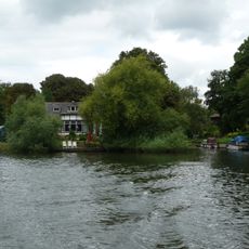
Staines Bridge is a stone arch bridge that crosses the River Thames with nine separate arches spanning its width. The structure connects the two riverbanks at Staines-upon-Thames and carries both road traffic and pedestrians.
A bridge has stood at this location since 1222, when maintenance work used timber sourced from Windsor Forest. The current stone structure was built in 1832 to replace earlier wooden versions as traffic demands increased.
The construction of Staines Bridge in 1832 marked a shift in bridge engineering, showcasing Aberdeen granite in infrastructure development.
The Thames Path runs across the bridge and allows walkers to move between Staines-upon-Thames and Egham on foot. Visitors can access both riverbanks and explore the surrounding area at their own pace.
The bridge provides limited headroom for river traffic, a constraint that shaped its design when waterborne commerce was still active. Today visitors can observe how engineering had to balance movement on water with movement on land.
Location: Runnymede
Location: Spelthorne
Inception: 1832
Official opening: 1832
GPS coordinates: 51.43327,-0.51690
Latest update: December 11, 2025 11:01
St Mary's, Staines
373 m
Church Island
289 m
Staines Railway Bridge
494 m
Hollyhock Island
816 m
Staines Town Hall
189 m
Holm Island
816 m
Anne Boleyn Hotel
109 m
Church of St Peter
757 m
57 and 59, Church Street
279 m
75, Church Street
288 m
The Swan Public House
98 m
Staines War Memorial
193 m
The Blue Anchor Public House
233 m
The London Stone
509 m
Coal Tax Post At West End Of The Hythe On Traffic Island
89 m
2 K6 Telephone Kiosks In Front Of Town Hall
182 m
Obelisk To North Of Railway Bridge
507 m
35, Clarence Street
121 m
44, 46 And 48, High Street
358 m
Fire Engine Shed
179 m
Milestone, 100m W of Staines Bridge, at Sainsbury's Roundabout off Causeway
244 m
Former Public Library
119 m
2, Clarence Street
199 m
George Hawkins Tomb In St Mary's Churchyard
352 m
Coal Tax Post North Side East End
85 m
1-11, the Hythe
74 m
Remains Of Bridge On River Thames Towpath (South Bank)
146 m
Boundary Wall Of Duncroft House
479 mVisited this place? Tap the stars to rate it and share your experience / photos with the community! Try now! You can cancel it anytime.
Discover hidden gems everywhere you go!
From secret cafés to breathtaking viewpoints, skip the crowded tourist spots and find places that match your style. Our app makes it easy with voice search, smart filtering, route optimization, and insider tips from travelers worldwide. Download now for the complete mobile experience.
A unique approach to discovering new places❞
— Le Figaro
All the places worth exploring❞
— France Info
A tailor-made excursion in just a few clicks❞
— 20 Minutes