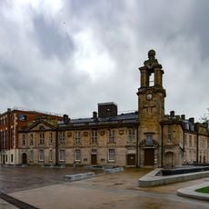
Sunderland Minster, Anglican church in Sunderland, England.
Sunderland Minster is a church at the heart of Sunderland, featuring traditional stone architecture and a prominent bell tower. The building displays classic elements typical of English church design, with solid walls and characteristic proportions.
The original church at this location was built around 940 AD when the parish of Bishopwearmouth was established south of the River Wear. It gained its Minster status in 1998, becoming the second Minster church in England since the Reformation.
The church serves as a gathering place for people from different backgrounds and beliefs across the city. It plays an important role in community life and creates space for various forms of connection.
The building is easily accessible during weekdays and active with services on weekends. Visitors should check regular opening times and plan visits around service schedules.
The building has maintained its presence at the location through many centuries of change in the city. This continuity across such a long timespan makes it a rare example of historical stability in English church life.
Location: Sunderland
GPS coordinates: 54.90580,-1.38885
Latest update: December 10, 2025 20:03
Sunderland Empire Theatre
70 m
Wearmouth Bridge
608 m
Sunderland Museum and Winter Gardens
575 m
Mowbray Park
728 m
Wearmouth Bridge
608 m
City Hall, Sunderland
288 m
Sunderland Civic Centre
657 m
Elephant Tea Rooms
465 m
St Mary's Church, Sunderland
476 m
Monkwearmouth Bridge
571 m
New Sunderland Square
288 m
Corder House and Sydenham House
474 m
Hawksley House
593 m
St George's Church, Sunderland
728 m
Monument To Jack Crawford At Ngr 3979 5652
662 m
West Park United Reformed Church
494 m
Statue of John Candlish
687 m
Post Office And Railings
678 m
Empire Cinema
573 m
The Dun Cow Public House
69 m
The Bridge Hotel
819 m
Statue of General Havelock in South West of Park, Building Hill Nz 3984 5639
787 m
War Memorial with Railings and Gates
578 m
Magistrates' Court
189 m
Barclays Bank
444 m
Medieval Arch In Wall To West Of Public Gardens
707 m
Footbridge Over Cutting Between Mowbray Park And Mowbray Extension Park
704 m
101, 102 And 103, High Street West
497 mVisited this place? Tap the stars to rate it and share your experience / photos with the community! Try now! You can cancel it anytime.
Discover hidden gems everywhere you go!
From secret cafés to breathtaking viewpoints, skip the crowded tourist spots and find places that match your style. Our app makes it easy with voice search, smart filtering, route optimization, and insider tips from travelers worldwide. Download now for the complete mobile experience.
A unique approach to discovering new places❞
— Le Figaro
All the places worth exploring❞
— France Info
A tailor-made excursion in just a few clicks❞
— 20 Minutes