Bethune Park, Urban park in Friern Barnet, United Kingdom
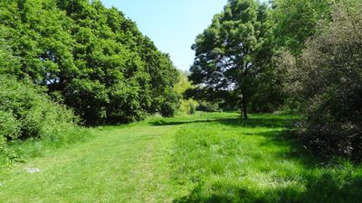
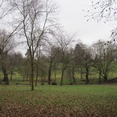
Bethune Park is an urban green space in Friern Barnet with open grass areas, walking paths, and distinct zones for different activities. The site includes sports facilities such as tennis courts and basketball areas, as well as treed sections and natural habitats.
The site was acquired by Friern Barnet Urban District Council in 1924 and officially opened in 1926 as Bethune Recreation Ground. This establishment reflected the growing demand for public recreational spaces during the interwar period.
The park serves the neighborhood as a gathering place where residents experience green space as part of their everyday routine. Local activities and informal meetings happen throughout the seasons in these open areas.
The park can be accessed from several entry points including Manor Drive and Gresham Avenue, making it easy to enter from different directions. Visitors should note that some areas may become muddy after rain, so appropriate footwear is advisable.
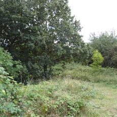
A substantial nature reserve area within the park functions as an ecological habitat supporting various bird species and small mammals. This zone allows visitors to observe local wildlife while staying within the park grounds.
Location: Friern Barnet Urban District
GPS coordinates: 51.61960,-0.15236
Latest update: December 13, 2025 11:40
Friary Park
705 m
Arnos Park Viaduct
1.2 km
St Mary the Virgin, East Barnet
1.8 km
St John's Church
739 m
Oakleigh Park Rail Cutting
1.6 km
Friern Barnet Parishioners War Memorial
811 m
St James the Great, Friern Barnet
792 m
St Paul's Church, New Southgate
887 m
Former Friern Barnet Town Hall
788 m
All Saints' Church
1.4 km
Christ Church at Whetstone
1.8 km
Barfield Allotments Nature Park
911 m
Christ Church New Southgate & Friern Barnet
572 m
Lawrence Campe Almshouses
1.4 km
Statue in Friary Park
596 m
36 And 38, Torrington Park N12
1.4 km
32 And 34, Torrington Park N12
1.5 km
Bowes Road Library And Arnos Pool
1.6 km
Memorial To German First World War Internees, New Southgate Cemetery
730 m
Osidge Library
1.2 km
Friern Barnet Community Library
679 m
St James's Primary School
1.3 km
Milestone Situated Outside Numbers 842 And 844 High Road 30 Yards South Of Ravensdale Avenue
1.7 km
Garden House Of Friern Hospital
820 m
Coachhouse Between Number 34 And 36
1.5 km
Boundary Marker
1.4 km
Lodge Of Friern Hospital
615 m
Friern Hospital
817 mVisited this place? Tap the stars to rate it and share your experience / photos with the community! Try now! You can cancel it anytime.
Discover hidden gems everywhere you go!
From secret cafés to breathtaking viewpoints, skip the crowded tourist spots and find places that match your style. Our app makes it easy with voice search, smart filtering, route optimization, and insider tips from travelers worldwide. Download now for the complete mobile experience.
A unique approach to discovering new places❞
— Le Figaro
All the places worth exploring❞
— France Info
A tailor-made excursion in just a few clicks❞
— 20 Minutes