Enable Location

We need your location to show you interesting places around you

Discover nearby places

Find interesting locations and hidden gems around you

Precise directions

Get accurate directions and distances to places

Your location is never shared with other users. It's only used when you tap the location button.

Former Friern Barnet Town Hall

Log in to your account

Start exploring — it's free

Trusted by 63,018 travelers worldwide

Continue with Google
Continue with Apple
or

We will send you a code to connect

By continuing, you accept our Terms and Conditions and our Privacy Policy

Check your inbox

We've sent a pincode in your inbox. Please enter the code below.

Former Friern Barnet Town Hall
Discussion Reviews 1 Photos
1.2k Popularity

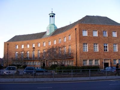
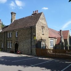
Former Friern Barnet Town Hall, Grade II listed office building in Friern Barnet, England.

The Former Friern Barnet Town Hall is a Grade II listed office building with a striking main frontage stretching across eleven bays and marked by a central entrance with a cast iron balcony. A clock tower crowns the composition and defines the character of the site.

The Neo-Georgian building was constructed in 1941 by architects Sir John Brown, A E Henson and Partners to serve as the headquarters for Friern Barnet Urban District Council. Following acquisition by Barratt Developments in 2002, it was transformed into residential apartments in 2005.

The building reflects municipal architecture from the 1940s, with balanced proportions and a symmetrical design that was typical of public buildings from that era. The careful planning shows how local councils expressed authority and stability through the way they built.

The building is now converted to private apartments and not open to the public, though the exterior facade can be viewed from the street. The converted spaces are known as Aldermen Court.

During World War II, the basement served as a control center for civil defense operations, repurposing the municipal building for wartime use. This hidden history connects the location to the dramatic events of that period.

The community of curious travelers

AroundUs brings together thousands of curated places, local tips, and hidden gems, enriched daily by 60,000 contributors worldwide.

Start exploring
GPS coordinates
51.61349,-0.15813
Latest update
December 14, 2025 18:40
Around this place
Artsdepot
United Kingdom

Artsdepot

1.3 km
Finchley Lido
United Kingdom

Finchley Lido

1.4 km
Friary Park
United Kingdom

Friary Park

631 m
Bethune Park
United Kingdom

Bethune Park

788 m
St John's Church
United Kingdom

St John's Church

254 m
Finchley War Memorial
United Kingdom

Finchley War Memorial

1.4 km
Friern Barnet Parishioners War Memorial
United Kingdom

Friern Barnet Parishioners War Memorial

944 m
St James the Great, Friern Barnet
United Kingdom

St James the Great, Friern Barnet

917 m
St Paul's Church, New Southgate
United Kingdom

St Paul's Church, New Southgate

1.2 km
Christ Church
United Kingdom

Christ Church

1.2 km
Barfield Allotments Nature Park
United Kingdom

Barfield Allotments Nature Park

1.5 km
St. Alban's Catholic Church
United Kingdom

St. Alban's Catholic Church

1.5 km
Christ Church New Southgate & Friern Barnet
United Kingdom

Christ Church New Southgate & Friern Barnet

685 m
Statue in Friary Park
United Kingdom

Statue in Friary Park

579 m
36 And 38, Torrington Park N12
United Kingdom

36 And 38, Torrington Park N12

1.1 km
32 And 34, Torrington Park N12
United Kingdom

32 And 34, Torrington Park N12

1.1 km
Memorial To German First World War Internees, New Southgate Cemetery
United Kingdom

Memorial To German First World War Internees, New Southgate Cemetery

1.5 km
Men of Finchley War Memorial, including the Finchley Metropolitan Tramway and Hendon Garage Memorial Tablets
United Kingdom

Men of Finchley War Memorial, including the Finchley Metropolitan Tramway and Hendon Garage Memorial Tablets

1.4 km
Friern Barnet Community Library
United Kingdom

Friern Barnet Community Library

323 m
St James's Primary School
United Kingdom

St James's Primary School

1.5 km
Melesi Mausoleum
United Kingdom

Melesi Mausoleum

1.3 km
Milestone Situated Outside Numbers 842 And 844 High Road 30 Yards South Of Ravensdale Avenue
United Kingdom

Milestone Situated Outside Numbers 842 And 844 High Road 30 Yards South Of Ravensdale Avenue

1.4 km
Garden House Of Friern Hospital
United Kingdom

Garden House Of Friern Hospital

757 m
Coachhouse Between Number 34 And 36
United Kingdom

Coachhouse Between Number 34 And 36

1.1 km
Boundary Marker
United Kingdom

Boundary Marker

702 m
Grandstand At Summers Lane Sports Ground
United Kingdom

Grandstand At Summers Lane Sports Ground

1.1 km
Lodge Of Friern Hospital
United Kingdom

Lodge Of Friern Hospital

650 m
Friern Hospital
United Kingdom

Friern Hospital

753 m
Show the full map
Reviews
Share your experience

No review yet

Discussions
Start a discussion...

No discussion yet

« Former Friern Barnet Town Hall - Grade II listed office building in Friern Barnet, England » is provided by Around Us (aroundus.com). Images and texts are derived from Wikimedia project under a Creative Commons license. You are allowed to copy, distribute, and modify copies of this page, under the conditions set by the license, as long as this note is clearly visible.

Discover hidden gems everywhere you go!

From secret cafés to breathtaking viewpoints, skip the crowded tourist spots and find places that match your style. Our app makes it easy with voice search, smart filtering, route optimization, and insider tips from travelers worldwide. Download now for the complete mobile experience.

Around Us App Screenshot

A unique approach to discovering new places

Le Figaro

All the places worth exploring

France Info

A tailor-made excursion in just a few clicks

20 Minutes

Around Us
Travel Guide & Maps
Download

Send to your phone

QR Code
1

Open the camera app on your mobile.

2

Point at the QR code with your camera. A notification will appear.

3

Tap the notification to open the link.