Enable Location

We need your location to show you interesting places around you

Discover nearby places

Find interesting locations and hidden gems around you

Precise directions

Get accurate directions and distances to places

Your location is never shared with other users. It's only used when you tap the location button.

Church of St Mary

Log in to your account

Start exploring — it's free

Trusted by 63,493 travelers worldwide

Continue with Google
Continue with Apple
or

We will send you a code to connect

By continuing, you accept our Terms and Conditions and our Privacy Policy

Check your inbox

We've sent a pincode in your inbox. Please enter the code below.

Church of St Mary
Discussion Reviews 1 Photos
1.4k Popularity

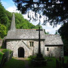
Church of St Mary, Medieval church in Oare, England.

The Church of St Mary is a medieval religious building with stone walls, timber roof supports, and several Gothic windows that light the interior. The structure displays classic features of sacred architecture from that era.

The church was built during the medieval period and holds Grade II* listed status, reflecting its architectural significance. Since its creation, it has mirrored centuries of community religious practice.

The church serves as the village's main gathering place for worship and local celebrations, where people come together for significant occasions.

The building is open during daylight hours and fits well into a stroll through the village. The graveyard holds several old headstones that can be explored during a quiet visit.

The graveyard contains old headstones with inscriptions that provide information about the earliest residents of the place. These carvings tell personal stories of villagers from earlier times.

The community of curious travelers

AroundUs brings together thousands of curated places, local tips, and hidden gems, enriched daily by 60,000 contributors worldwide.

Start exploring
Location
GPS coordinates
51.21240,-3.71642
Latest update
December 14, 2025 16:47
Around this place
Culbone Church
United Kingdom

Culbone Church

4.1 km
Exmoor National Park
United Kingdom

Exmoor National Park

5.6 km
Porlock Stone Circle
United Kingdom

Porlock Stone Circle

5 km
Watersmeet House
United Kingdom

Watersmeet House

5.9 km
Porlock Bay
United Kingdom

Porlock Bay

7.8 km
Lynmouth Foreland Lighthouse
United Kingdom

Lynmouth Foreland Lighthouse

6.1 km
Robber's Bridge
United Kingdom

Robber's Bridge

2 km
Glenthorne
United Kingdom

Glenthorne

2.4 km
Malmsmead Bridge
United Kingdom

Malmsmead Bridge

1.1 km
Roborough Castle
United Kingdom

Roborough Castle

7.3 km
Alderman's Barrow at N of Almsworthy Common
United Kingdom

Alderman's Barrow at N of Almsworthy Common

6.1 km
The Blue Ball Inn
United Kingdom

The Blue Ball Inn

6 km
Church of St John the Baptist
United Kingdom

Church of St John the Baptist

8 km
Church of Saint John
United Kingdom

Church of Saint John

6 km
Church of St Brendan
United Kingdom

Church of St Brendan

5.2 km
Lyn Model Railway
United Kingdom

Lyn Model Railway

8 km
Sisters Fountain And Adjoining Pool Approximately 700 Metres To South West Pf Glenthorne At Ss 7930 4917
United Kingdom

Sisters Fountain And Adjoining Pool Approximately 700 Metres To South West Pf Glenthorne At Ss 7930 4917

2.1 km
Stone circle, Porlock Common
United Kingdom

Stone circle, Porlock Common

5.1 km
Orchard House And Attached Front Boundary Wall
United Kingdom

Orchard House And Attached Front Boundary Wall

8 km
Hillside House And Front Terrace Wall And Railings
United Kingdom

Hillside House And Front Terrace Wall And Railings

7.9 km
Beach Cottage
United Kingdom

Beach Cottage

6.3 km
Pair Of Lime Kilns Approximately 200 Metres To East Of Watersmeet House
United Kingdom

Pair Of Lime Kilns Approximately 200 Metres To East Of Watersmeet House

5.7 km
Bonnicott
United Kingdom

Bonnicott

8 km
Summerhouse And Attached Retaining Wall And Terrace With Railings
United Kingdom

Summerhouse And Attached Retaining Wall And Terrace With Railings

7.9 km
Oare Bridge
United Kingdom

Oare Bridge

144 m
Packhorse Bridge Approximately 30 Metres To West Of Leeford Bridge (That Part In Brendon Cp)
United Kingdom

Packhorse Bridge Approximately 30 Metres To West Of Leeford Bridge (That Part In Brendon Cp)

3.4 km
The Whit Stones: two standing stones 230m west of Whitstone Post
United Kingdom

The Whit Stones: two standing stones 230m west of Whitstone Post

5.2 km
Lyn Long Stones
United Kingdom

Lyn Long Stones

7.5 km
Show the full map
Reviews
Share your experience

No review yet

Discussions
Start a discussion...

No discussion yet

« Church of St Mary - Medieval church in Oare, England » is provided by Around Us (aroundus.com). Images and texts are derived from Wikimedia project under a Creative Commons license. You are allowed to copy, distribute, and modify copies of this page, under the conditions set by the license, as long as this note is clearly visible.

Discover hidden gems everywhere you go!

From secret cafés to breathtaking viewpoints, skip the crowded tourist spots and find places that match your style. Our app makes it easy with voice search, smart filtering, route optimization, and insider tips from travelers worldwide. Download now for the complete mobile experience.

Around Us App Screenshot

A unique approach to discovering new places

Le Figaro

All the places worth exploring

France Info

A tailor-made excursion in just a few clicks

20 Minutes

Around Us
Travel Guide & Maps
Download

Send to your phone

QR Code
1

Open the camera app on your mobile.

2

Point at the QR code with your camera. A notification will appear.

3

Tap the notification to open the link.