Embanked stone circle known as Wet Withens, and adjacent cairn
Embanked stone circle known as Wet Withens, and adjacent cairn, Bronze Age stone circle in Eyam, England
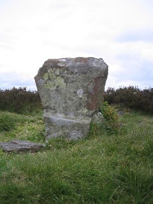
Wet Withens is a stone circle on Eyam Moor made up of ten upright stones arranged in a circular pattern that spans roughly 30 meters across. The site sits at about 335 meters elevation and includes an adjacent cairn, with both structures clearly visible on the open moorland.
The stone circle dates to the Bronze Age and was documented with sixteen stones in the 1840s, though the number decreased over time. By the late nineteenth century, several original stones had vanished, likely due to weathering and human activity.
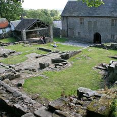
The stone circle and its adjacent cairn show how early communities buried their dead and gathered for shared rituals at this location. Both structures worked together to serve the spiritual and ceremonial needs of the people who lived nearby.
The site is accessible from Eyam village via public footpaths and offers views across the surrounding landscape. Since it sits on open moorland, visitors should be prepared for changeable weather and wear sturdy footwear.
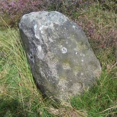
Among the stones stands a distinctive one known as the Chair Stone, roughly 70 centimeters tall, which features a natural depression resembling a seat. This rock formation often goes unnoticed by visitors exploring the circle.
Location: Eyam
GPS coordinates: 53.30750,-1.66314
Latest update: December 14, 2025 11:22
Eyam Museum
2.5 km
Padley Chapel
2.1 km
Mompesson's Well
1.8 km
Padley Hall
2.2 km
Highlow Hall
1.3 km
Stanage Cairn
1.1 km
Roman Catholic Church of St Michael
2.6 km
Foresters House
2.6 km
Brunt's Barn, Upper Padley, Grindleford
2.1 km
Hathersage Viaduct
2.3 km
Padley Mill
2.5 km
Ruins of Bradshaw Hall
2.5 km
Wall And Water Troughs To South East Of Edge Moor
2.5 km
Grindleford Bridge
2.3 km
Booth's Farmhouse
2.4 km
Offerton Hall
2.4 km
The Olde House and attached garage
2.5 km
Leadmill Bridge
1.8 km
Merrill House
2.5 km
Lower Booths Farmhouse
2.3 km
Hall Farmhouse
2.6 km
Lamp column to the north east of Hathersage Farmhouse
2.5 km
Outbuilding To South Of Merrill House
2.5 km
Edge Lea
2.5 km
Nether Hall
2.1 km
Tomb of H Merrill, 25 metres north of Hollins Farmhouse (SK214768)
2.4 km
Milestone, Grindleford, E of Sheriff Wood (Leam Hall)
1.5 km
Milestone, The Crofts, at jct with Main Road, opp service station, to left of public toilets
2.6 kmVisited this place? Tap the stars to rate it and share your experience / photos with the community! Try now! You can cancel it anytime.
Discover hidden gems everywhere you go!
From secret cafés to breathtaking viewpoints, skip the crowded tourist spots and find places that match your style. Our app makes it easy with voice search, smart filtering, route optimization, and insider tips from travelers worldwide. Download now for the complete mobile experience.
A unique approach to discovering new places❞
— Le Figaro
All the places worth exploring❞
— France Info
A tailor-made excursion in just a few clicks❞
— 20 Minutes