Enable Location

We need your location to show you interesting places around you

Discover nearby places

Find interesting locations and hidden gems around you

Precise directions

Get accurate directions and distances to places

Your location is never shared with other users. It's only used when you tap the location button.

Killin Stone Circle

Log in to your account

Start exploring — it's free

Trusted by 62,834 travelers worldwide

Continue with Google
Continue with Apple
or

We will send you a code to connect

By continuing, you accept our Terms and Conditions and our Privacy Policy

Check your inbox

We've sent a pincode in your inbox. Please enter the code below.

Killin Stone Circle

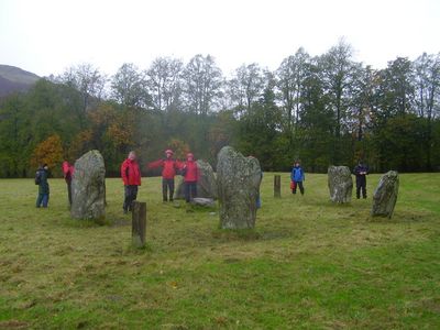
Killin Stone Circle, Prehistoric stone circle in Stirling, Scotland

Killin Stone Circle comprises six upright slabs of dark grey schist arranged to form a flattened circle with a diameter of about 10 meters. The stones stand in a geometric pattern that has remained largely unchanged over thousands of years.

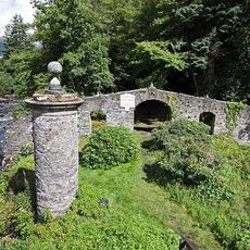
This stone formation dates from the Neolithic or Bronze Age and stands as one of the westernmost ceremonial structures in central Scotland. The site survived centuries of change through its location on Kinnell House grounds, possibly receiving restoration work during the 1800s.

Three cup marks carved into the northernmost stone suggest this place held ritual meaning for the prehistoric people living in the area. These marks show how people gathered here to participate in ceremonies tied to their understanding of the land.

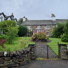
The site sits near Kinnell House on private land and requires permission from the owner to visit. Access comes through a metal gate that leads into the surrounding pasture, so arrange ahead with the landowner.

The cup marks carved into the stones are a form of prehistoric marking whose exact purpose remains a puzzle to archaeologists. These cryptic symbols hint that ancient people held complex ideas we still do not fully understand today.

The community of curious travelers

AroundUs brings together thousands of curated places, local tips, and hidden gems, enriched daily by 60,000 contributors worldwide.

Start exploring
Location
GPS coordinates
56.46583,-4.31124
Latest update
December 13, 2025 11:40
Around this place
Finlarig Castle
United Kingdom

Finlarig Castle

1 km
Falls of Dochart
United Kingdom

Falls of Dochart

662 m
Moirlanich Longhouse
United Kingdom

Moirlanich Longhouse

2 km
Meall nan Tarmachan
United Kingdom

Meall nan Tarmachan

6.2 km
Inchbuie
United Kingdom

Inchbuie

534 m
Falls of Lochay
United Kingdom

Falls of Lochay

4.1 km
Bridge Of Dochart
United Kingdom

Bridge Of Dochart

637 m
Dochart Viaduct
United Kingdom

Dochart Viaduct

270 m
Killin, Innes Bhuidhe, Burial Ground Of The Macnabs
United Kingdom

Killin, Innes Bhuidhe, Burial Ground Of The Macnabs

418 m
Birchbank, Main Street, Killin
United Kingdom

Birchbank, Main Street, Killin

506 m
The Manse, Killin
United Kingdom

The Manse, Killin

805 m
Burial-Ground, Killin Parish Church
United Kingdom

Burial-Ground, Killin Parish Church

617 m
Killin Parish Church
United Kingdom

Killin Parish Church

568 m
Meall Dhuin Croisg
United Kingdom

Meall Dhuin Croisg

5.2 km
House Adjoining Masonic Hall, Main Street, Killin
United Kingdom

House Adjoining Masonic Hall, Main Street, Killin

513 m
Masonic Hall, Main Street, Killin
United Kingdom

Masonic Hall, Main Street, Killin

522 m
Ashlea, Main Street, Killin
United Kingdom

Ashlea, Main Street, Killin

491 m
Creag Mhor
United Kingdom

Creag Mhor

6.4 km
Mansefield, Manse Road, Killin
United Kingdom

Mansefield, Manse Road, Killin

578 m
James Stewart Memorial Including Railings, Killin
United Kingdom

James Stewart Memorial Including Railings, Killin

590 m
Glengarry, Main Street, Killin
United Kingdom

Glengarry, Main Street, Killin

499 m
St Fillan's Episcopal Church, Main Street, Killin
United Kingdom

St Fillan's Episcopal Church, Main Street, Killin

486 m
Glen Ogle, 12 Arch Railway Viaduct
United Kingdom

Glen Ogle, 12 Arch Railway Viaduct

6.4 km
Dreadnought Place Including Ancillary Structure And Boundary Walls, Main Street, Killin
United Kingdom

Dreadnought Place Including Ancillary Structure And Boundary Walls, Main Street, Killin

484 m
Killin, Dochart Mill
United Kingdom

Killin, Dochart Mill

687 m
Dreadnought Place Including Ancillary Structure And Boundary Walls, Main Street, Killin
United Kingdom

Dreadnought Place Including Ancillary Structure And Boundary Walls, Main Street, Killin

486 m
Lynedoch Including Boundary Walls, Main Street, Killin
United Kingdom

Lynedoch Including Boundary Walls, Main Street, Killin

436 m
Station House And Tarmachan Teashop, Larachbeag, Killin
United Kingdom

Station House And Tarmachan Teashop, Larachbeag, Killin

461 m
Show the full map
« Killin Stone Circle - Prehistoric stone circle in Stirling, Scotland » is provided by Around Us (aroundus.com). Images and texts are derived from Wikimedia project under a Creative Commons license. You are allowed to copy, distribute, and modify copies of this page, under the conditions set by the license, as long as this note is clearly visible.

Discover hidden gems everywhere you go!

From secret cafés to breathtaking viewpoints, skip the crowded tourist spots and find places that match your style. Our app makes it easy with voice search, smart filtering, route optimization, and insider tips from travelers worldwide. Download now for the complete mobile experience.

Around Us App Screenshot

A unique approach to discovering new places

Le Figaro

All the places worth exploring

France Info

A tailor-made excursion in just a few clicks

20 Minutes

Around Us
Travel Guide & Maps
Download

Send to your phone

QR Code
1

Open the camera app on your mobile.

2

Point at the QR code with your camera. A notification will appear.

3

Tap the notification to open the link.