Enable Location

We need your location to show you interesting places around you

Discover nearby places

Find interesting locations and hidden gems around you

Precise directions

Get accurate directions and distances to places

Your location is never shared with other users. It's only used when you tap the location button.

Finlarig Castle

Log in to your account

Start exploring — it's free

Trusted by 61,451 travelers worldwide

Continue with Google
Continue with Apple
or

We will send you a code to connect

By continuing, you accept our Terms and Conditions and our Privacy Policy

Check your inbox

We've sent a pincode in your inbox. Please enter the code below.

Finlarig Castle

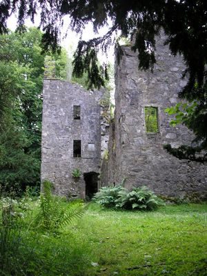
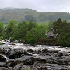
Finlarig Castle, Medieval castle in Killin, Scotland

Description

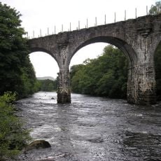
Finlarig Castle is a tower house with an L-shaped design that sits on a narrow piece of land between the River Lochay and Loch Tay, with defensive towers anchoring opposite corners. The water surroundings shaped its defensive purpose and overall structure over the centuries.

History

Built in 1629 by Duncan Campbell, the castle became a stronghold for the Breadalbane branch of the Campbell family across the Scottish highlands. Its construction marked the establishment of a key power base in the region.

Culture

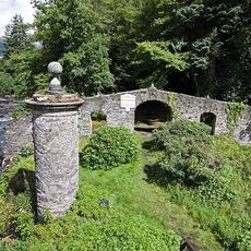
The Breadalbane Mausoleum near the ruins reflects the Campbell family's deep roots in the area and their place in local memory. Walking around it today, you see the inscriptions and stonework that mark the connection between this family and the landscape.

Practical

The ruins are unstable and require care when exploring, so visitors should watch their step on the uneven ground and damaged sections. The site sits in an open landscape between the water bodies, making it accessible to walk around and observe from different angles.

Did you know?

A stone-lined pit on the north side was used for executing nobles, while a nearby oak tree served as the place for common prisoners. This difference in punishment based on rank reveals the rigid social divisions of the era.

Location
GPS coordinates
56.47500,-4.31506
Latest update
December 8, 2025 19:46

AroundUs brings together thousands of curated places, local tips, and hidden gems, enriched daily by 60,000 contributors worldwide. Discover all places nearby (Stirling).

Around this place
Falls of Dochart
United Kingdom

Falls of Dochart

1.4 km
Moirlanich Longhouse
United Kingdom

Moirlanich Longhouse

1.3 km
Meall nan Tarmachan
United Kingdom

Meall nan Tarmachan

5.3 km
Killin Stone Circle
United Kingdom

Killin Stone Circle

1 km
Inchbuie
United Kingdom

Inchbuie

1.4 km
Falls of Lochay
United Kingdom

Falls of Lochay

3.4 km
Bridge Of Dochart
United Kingdom

Bridge Of Dochart

1.4 km
Dochart Viaduct
United Kingdom

Dochart Viaduct

1.1 km
Killin, Innes Bhuidhe, Burial Ground Of The Macnabs
United Kingdom

Killin, Innes Bhuidhe, Burial Ground Of The Macnabs

1.2 km
Birchbank, Main Street, Killin
United Kingdom

Birchbank, Main Street, Killin

1.1 km
The Manse, Killin
United Kingdom

The Manse, Killin

617 m
Lawers Dam
United Kingdom

Lawers Dam

5.9 km
Burial-Ground, Killin Parish Church
United Kingdom

Burial-Ground, Killin Parish Church

509 m
Killin Parish Church
United Kingdom

Killin Parish Church

605 m
Meall Dhuin Croisg
United Kingdom

Meall Dhuin Croisg

4.3 km
House Adjoining Masonic Hall, Main Street, Killin
United Kingdom

House Adjoining Masonic Hall, Main Street, Killin

1.1 km
Masonic Hall, Main Street, Killin
United Kingdom

Masonic Hall, Main Street, Killin

1.1 km
Ashlea, Main Street, Killin
United Kingdom

Ashlea, Main Street, Killin

1.1 km
Creag Mhor
United Kingdom

Creag Mhor

6.1 km
Mansefield, Manse Road, Killin
United Kingdom

Mansefield, Manse Road, Killin

1.2 km
St Fillan's Episcopal Church, Main Street, Killin
United Kingdom

St Fillan's Episcopal Church, Main Street, Killin

683 m
Glengarry, Main Street, Killin
United Kingdom

Glengarry, Main Street, Killin

1.1 km
James Stewart Memorial Including Railings, Killin
United Kingdom

James Stewart Memorial Including Railings, Killin

613 m
Killin, Dochart Mill
United Kingdom

Killin, Dochart Mill

1.4 km
Dreadnought Place Including Ancillary Structure And Boundary Walls, Main Street, Killin
United Kingdom

Dreadnought Place Including Ancillary Structure And Boundary Walls, Main Street, Killin

736 m
Lynedoch Including Boundary Walls, Main Street, Killin
United Kingdom

Lynedoch Including Boundary Walls, Main Street, Killin

927 m
Dreadnought Place Including Ancillary Structure And Boundary Walls, Main Street, Killin
United Kingdom

Dreadnought Place Including Ancillary Structure And Boundary Walls, Main Street, Killin

726 m
Station House And Tarmachan Teashop, Larachbeag, Killin
United Kingdom

Station House And Tarmachan Teashop, Larachbeag, Killin

713 m
Show the full map
« Finlarig Castle - Medieval castle in Killin, Scotland » is provided by Around Us (aroundus.com). Images and texts are derived from Wikimedia project under a Creative Commons license. You are allowed to copy, distribute, and modify copies of this page, under the conditions set by the license, as long as this note is clearly visible.

Discover hidden gems everywhere you go!

From secret cafés to breathtaking viewpoints, skip the crowded tourist spots and find places that match your style. Our app makes it easy with voice search, smart filtering, route optimization, and insider tips from travelers worldwide. Download now for the complete mobile experience.

Around Us App Screenshot

A unique approach to discovering new places

Le Figaro

All the places worth exploring

France Info

A tailor-made excursion in just a few clicks

20 Minutes

Around Us
Travel Guide & Maps
Download

Send to your phone

QR Code
1

Open the camera app on your mobile.

2

Point at the QR code with your camera. A notification will appear.

3

Tap the notification to open the link.