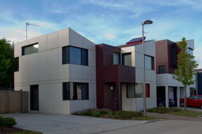
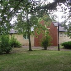
Oxley Woods, Modern residential development in Milton Keynes, England.
Oxley Woods is a residential community in Milton Keynes featuring approximately 145 homes that range from compact two-bedroom maisonettes to larger five-bedroom family houses. The properties are distributed throughout the Oxley Park area and follow a cohesive, contemporary design approach.
The development emerged in 2004 through a design competition run by the Office of the Deputy Prime Minister, seeking innovative solutions for affordable housing across England. This initiative represented an effort to develop new construction methods and more sustainable residential concepts.
The development reflects British architectural innovation through its integration of sustainable design principles and community-focused spatial planning in suburban environments.
Each house includes a specialized ventilation system called EcoHat that recycles warm air throughout the building to reduce energy consumption and lower heating costs. This system is built into all homes and helps improve overall energy efficiency.
The homes were produced using factory-based manufacturing methods, with each property manufactured in approximately one week and then rapidly assembled on site. This efficient production process was central to the innovative approach underlying the competition that created this community.
Location: England
GPS coordinates: 52.01080,-0.80490
Latest update: December 13, 2025 17:00
National Bowl
3.2 km
The National Museum of Computing
4.4 km
Whaddon Hall
1.6 km
Quadrant:MK
3.6 km
Energy World
2.4 km
Snelshall Priory
1 km
All Saints Church, Loughton
3 km
Church of the Servant King, Furzton
2.4 km
St Giles's Church, Tattenhoe
1.6 km
St. Mary's Church, Shenley
1.7 km
Oxley Mead
624 m
Church of the Holy Cross, Two Mile Ash
3.1 km
Church of St Mary
2.1 km
Church of St Lawrence
4.2 km
Church of All Saints
4.2 km
Chapel To North Of Bradwell Abbey House
4.3 km
Christ the Vine
4.3 km
The Talbot Inn
2.2 km
Shenley War Memorial
1.7 km
Former Bus Station, Station Square, Milton Keynes
3.5 km
Denbigh Hall Railway Bridge
4.2 km
The Bungalow And Attached Wall To E And Stable Range To East And Stable Range To South
4.5 km
Old Bletchley War Memorial
4.5 km
The Crooked Billet
4.5 km
Milestone, Watling Street; on brow of hill in open area, Two Mile Ash
2.9 km
Milestone, Watling Street; 100m W of roundabout with Standing Way, W of Redmoor
3.6 km
Milestone, Watling Street; Shenley Lodge, at jct with Kelvin Drive, N of Chaffron Way roundabout
2.6 km
Milestone, Watling Street; at jct with Old Bell Lane, N of Shenley Church End
2.2 kmVisited this place? Tap the stars to rate it and share your experience / photos with the community! Try now! You can cancel it anytime.
Discover hidden gems everywhere you go!
From secret cafés to breathtaking viewpoints, skip the crowded tourist spots and find places that match your style. Our app makes it easy with voice search, smart filtering, route optimization, and insider tips from travelers worldwide. Download now for the complete mobile experience.
A unique approach to discovering new places❞
— Le Figaro
All the places worth exploring❞
— France Info
A tailor-made excursion in just a few clicks❞
— 20 Minutes