Enable Location

We need your location to show you interesting places around you

Discover nearby places

Find interesting locations and hidden gems around you

Precise directions

Get accurate directions and distances to places

Your location is never shared with other users. It's only used when you tap the location button.

Cohoes Falls

Log in to your account

Start exploring — it's free

Trusted by 63,096 travelers worldwide

Continue with Google
Continue with Apple
or

We will send you a code to connect

By continuing, you accept our Terms and Conditions and our Privacy Policy

Check your inbox

We've sent a pincode in your inbox. Please enter the code below.

Cohoes Falls
Discussion Reviews 1 Photos
13.1k Popularity

Cohoes Falls, Natural waterfall in Cohoes, United States

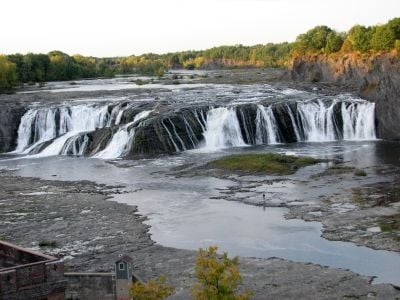
Cohoes Falls is a waterfall spanning 305 meters across the Mohawk River between Cohoes and Waterford. Water plunges down 28 meters at this location, creating a substantial natural feature that dominates the local landscape.

Dutch explorers documented a canoe accident at this location in the 17th century, providing early European records of the formation. This incident shows that travelers had long recognized the falls as a hazardous stretch of river to navigate.

This place holds deep meaning for the Haudenosaunee people, whose stories speak of a great peacemaker connected to these waters. The community continues to recognize this location as central to their history and identity.

Falls View Park offers viewing platforms and informational displays for visitors. Access is available during the warmer months, and a pedestrian bridge helps you reach the best viewing spots along the falls.

During summer months, lower water levels expose the shale rock formations beneath the falls, revealing geological layers millions of years old. These visible stone patterns tell the story of how the river has shaped the landscape over deep time.

The community of curious travelers

AroundUs brings together thousands of curated places, local tips, and hidden gems, enriched daily by 60,000 contributors worldwide.

Start exploring
Location
Location
Height
28 m
Width
305 m
Part of
Mohawk River
GPS coordinates
42.78800,-73.70850
Latest update
December 7, 2025 20:41
Around this place
Thaddeus Kosciusko Bridge
United States of America

Thaddeus Kosciusko Bridge

4.3 km
Peebles Island State Park
United States of America

Peebles Island State Park

2.1 km
Harmony Mills
United States of America

Harmony Mills

845 m
Cohoes Music Hall
United States of America

Cohoes Music Hall

1.5 km
Day Peckinpaugh
United States of America

Day Peckinpaugh

2.6 km
Urger
United States of America

Urger

2 km
Collar City Bridge
United States of America

Collar City Bridge

5.6 km
112th Street Bridge
United States of America

112th Street Bridge

2.8 km
Downtown Cohoes Historic District
United States of America

Downtown Cohoes Historic District

1.7 km
Lansingburgh Academy
United States of America

Lansingburgh Academy

3.1 km
Crescent Bridge
United States of America

Crescent Bridge

4.2 km
Troy–Waterford Bridge
United States of America

Troy–Waterford Bridge

2.8 km
Harmony Mill No. 3
United States of America

Harmony Mill No. 3

753 m
Van Schaick House
United States of America

Van Schaick House

2.9 km
Lock 18 of Enlarged Erie Canal
United States of America

Lock 18 of Enlarged Erie Canal

435 m
Oakcliff
United States of America

Oakcliff

4.4 km
Haskell School
United States of America

Haskell School

4.2 km
Rensselaer and Saratoga Railroad: Green Island Shops
United States of America

Rensselaer and Saratoga Railroad: Green Island Shops

4.4 km
Olmstead Street Historic District
United States of America

Olmstead Street Historic District

1.6 km
Waterford Village Historic District
United States of America

Waterford Village Historic District

2.4 km
Northside Historic District
United States of America

Northside Historic District

1.3 km
Cohoes City Hall
United States of America

Cohoes City Hall

1.7 km
Trinity Church Lansingburgh
United States of America

Trinity Church Lansingburgh

3.1 km
J. Leonard Lackman House
United States of America

J. Leonard Lackman House

1.9 km
William J. Dickey House
United States of America

William J. Dickey House

1.9 km
St. Mark's Episcopal Church
United States of America

St. Mark's Episcopal Church

5.3 km
Noxon Bank Building
United States of America

Noxon Bank Building

4.4 km
Ormsby-Laughlin Textile Companies Mill
United States of America

Ormsby-Laughlin Textile Companies Mill

2.1 km
Show the full map
Reviews
Share your experience

No review yet

Discussions
Start a discussion...

No discussion yet

« Cohoes Falls - Natural waterfall in Cohoes, United States » is provided by Around Us (aroundus.com). Images and texts are derived from Wikimedia project under a Creative Commons license. You are allowed to copy, distribute, and modify copies of this page, under the conditions set by the license, as long as this note is clearly visible.

Discover hidden gems everywhere you go!

From secret cafés to breathtaking viewpoints, skip the crowded tourist spots and find places that match your style. Our app makes it easy with voice search, smart filtering, route optimization, and insider tips from travelers worldwide. Download now for the complete mobile experience.

Around Us App Screenshot

A unique approach to discovering new places

Le Figaro

All the places worth exploring

France Info

A tailor-made excursion in just a few clicks

20 Minutes

Around Us
Travel Guide & Maps
Download

Send to your phone

QR Code
1

Open the camera app on your mobile.

2

Point at the QR code with your camera. A notification will appear.

3

Tap the notification to open the link.