Enable Location

We need your location to show you interesting places around you

Discover nearby places

Find interesting locations and hidden gems around you

Precise directions

Get accurate directions and distances to places

Your location is never shared with other users. It's only used when you tap the location button.

DeSoto Falls

Log in to your account

Start exploring — it's free

Trusted by 65,117 travelers worldwide

Continue with Google
Continue with Apple
or

We will send you a code to connect

By continuing, you accept our Terms and Conditions and our Privacy Policy

Check your inbox

We've sent a pincode in your inbox. Please enter the code below.

DeSoto Falls
Discussion Reviews 1 Photos
5.6k Popularity

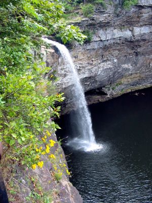
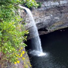
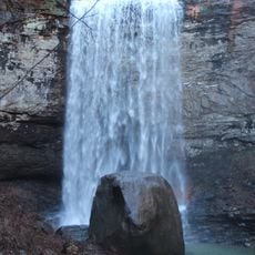
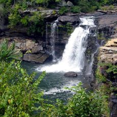
DeSoto Falls, 104-foot waterfall in DeSoto State Park, Alabama.

DeSoto Falls is a waterfall in DeSoto State Park on Lookout Mountain in Alabama, where the water of the West Fork Little River drops over a large rock formation into a deep pool below. The fall reaches about 100 feet (30 m) in height, making it one of the tallest waterfalls in the state.

In the 1930s, workers from the Civilian Conservation Corps built the paths, viewing areas, and other structures around the falls. That work shaped the park layout that visitors still use today.

The falls take their name from the Spanish explorer Hernando de Soto, who traveled through the southeastern part of North America in the 16th century. His name appears across this region on towns, parks, and landmarks, making the falls part of a broader pattern of historical memory you can trace as you travel through Alabama.

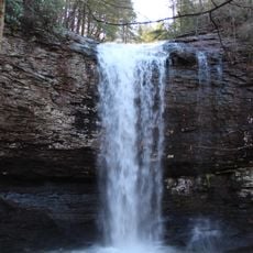
A paved path leads from the park facilities to an observation platform with a direct view of the falls, and the walk involves a short set of steps. The route is manageable for most visitors, though sturdy footwear helps on the uneven sections near the base.

The West Fork Little River is one of the few rivers in the United States that runs its entire course on top of a mountain plateau before finally reaching the edge. This means the falls mark the point where the river meets the rim of Lookout Mountain and drops for the first time.

The community of curious travelers

AroundUs brings together thousands of curated places, local tips, and hidden gems, enriched daily by 60,000 contributors worldwide.

Start exploring
Location
Part of
Little River Canyon National Preserve
GPS coordinates
34.54876,-85.59073
Latest update
March 3, 2026 10:08
Around this place
United States of America

Ellison's Cave

24.5 km
United States of America

Petty John's Cave

24.4 km
DeSoto State Park
United States of America

DeSoto State Park

6.5 km
James H. Floyd State Park
United States of America

James H. Floyd State Park

26.2 km
Hemlock Falls
United States of America

Hemlock Falls

33.4 km
Little River Falls
United States of America

Little River Falls

17.4 km
Cherokee Falls
United States of America

Cherokee Falls

33.2 km
Cherokee Plantation
United States of America

Cherokee Plantation

10.1 km
Old Union Crossing Covered Bridge
United States of America

Old Union Crossing Covered Bridge

1.8 km
Marsh-Warthen House
United States of America

Marsh-Warthen House

33.5 km
W. B. Davis Hosiery Mill
United States of America

W. B. Davis Hosiery Mill

16.2 km
McLemore Cove
United States of America

McLemore Cove

14.8 km
Winston Place
United States of America

Winston Place

3.1 km
Fort Payne Opera House
United States of America

Fort Payne Opera House

16.7 km
Walker County Courthouse
United States of America

Walker County Courthouse

33.3 km
Dr. J.A. Gorman House
United States of America

Dr. J.A. Gorman House

3.2 km
Fort Payne Main Street Historic District
United States of America

Fort Payne Main Street Historic District

17 km
Vance C. Larmore House
United States of America

Vance C. Larmore House

6.5 km
Fort Payne Boom Town Historic District
United States of America

Fort Payne Boom Town Historic District

16.6 km
Chattooga Academy
United States of America

Chattooga Academy

33.5 km
Chattooga County Courthouse
United States of America

Chattooga County Courthouse

23.5 km
United States of America

Penn Place

26.4 km
Fort Payne Residential Historic District
United States of America

Fort Payne Residential Historic District

16.9 km
Summerville Commercial Historic District
United States of America

Summerville Commercial Historic District

23.5 km
Mushroom Rock
United States of America

Mushroom Rock

19.8 km
Henagar Drive-In
United States of America

Henagar Drive-In

12.5 km
Mars Theatre
United States of America

Mars Theatre

32.8 km
DeKalb Theatre
United States of America

DeKalb Theatre

16.4 km
Show the full map
Reviews
Share your experience

No review yet

Discussions
Start a discussion...

No discussion yet

« DeSoto Falls - 104-foot waterfall in DeSoto State Park, Alabama » is provided by Around Us (aroundus.com). Images and texts are derived from Wikimedia project under a Creative Commons license. You are allowed to copy, distribute, and modify copies of this page, under the conditions set by the license, as long as this note is clearly visible.

Discover hidden gems everywhere you go!

From secret cafés to breathtaking viewpoints, skip the crowded tourist spots and find places that match your style. Our app makes it easy with voice search, smart filtering, route optimization, and insider tips from travelers worldwide. Download now for the complete mobile experience.

Around Us App Screenshot

A unique approach to discovering new places

Le Figaro

All the places worth exploring

France Info

A tailor-made excursion in just a few clicks

20 Minutes

Around Us
Travel Guide & Maps
Download

Send to your phone

QR Code
1

Open the camera app on your mobile.

2

Point at the QR code with your camera. A notification will appear.

3

Tap the notification to open the link.