·

Enable Location

We need your location to show you interesting places around you

Discover nearby places

Find interesting locations and hidden gems around you

Precise directions

Get accurate directions and distances to places

Your location is never shared with other users. It's only used when you tap the location button.

DeSoto State Park

Log in to your account

Start exploring — it's free

Trusted by 62,654 travelers worldwide

Continue with Google
Continue with Apple
or

We will send you a code to connect

By continuing, you accept our Terms and Conditions and our Privacy Policy

Check your inbox

We've sent a pincode in your inbox. Please enter the code below.

DeSoto State Park

DeSoto State Park, Mountain state park in Fort Payne, United States.

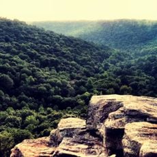
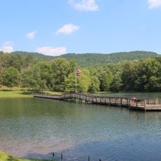
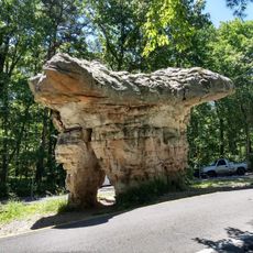
DeSoto State Park is a mountain park spanning roughly 3,500 acres across Lookout Mountain with dense forests, flowing rivers, and multiple cascades throughout. The landscape features varied terrain and natural scenery near Little River Canyon.

The Civilian Conservation Corps built the park in the 1930s, and it was officially dedicated as Alabama's fifth state park in 1939. This early development established the foundation for the landscape visitors see today.

The park's museum honors the Civilian Conservation Corps workers who shaped the landscape during the 1930s, their labor still visible in the trails and structures throughout the grounds.

The park offers 25 miles of hiking paths with 11 miles dedicated to mountain biking, catering to different skill levels. Lodging options range from cabins to campsites, and a seasonal pool operates during warmer months.

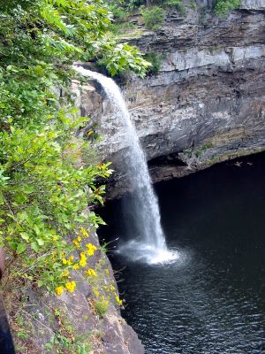
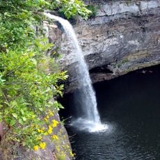
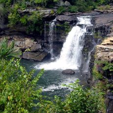
DeSoto Falls sits six miles north in a separate section and drops 104 feet, making it Alabama's tallest waterfall. This distinct area draws many visitors who want to see and photograph this dramatic cascade.

The community of curious travelers

AroundUs brings together thousands of curated places, local tips, and hidden gems, enriched daily by 60,000 contributors worldwide.

Start exploring
Location
Elevation above the sea
458 m
Operator
Alabama State Parks Division
GPS coordinates
34.49556,-85.61889
Latest update
December 8, 2025 19:52
Around this place
Weiss Lake
United States of America

Weiss Lake

32.9 km
Buck's Pocket State Park
United States of America

Buck's Pocket State Park

39.5 km
DeSoto Falls
United States of America

DeSoto Falls

6.5 km
James H. Floyd State Park
United States of America

James H. Floyd State Park

26.6 km
King Archaeological Site
United States of America

King Archaeological Site

39.5 km
Little River Falls
United States of America

Little River Falls

11.2 km
Comer Bridge
United States of America

Comer Bridge

36.7 km
Cherokee Plantation
United States of America

Cherokee Plantation

4.9 km
Old Union Crossing Covered Bridge
United States of America

Old Union Crossing Covered Bridge

4.7 km
W. B. Davis Hosiery Mill
United States of America

W. B. Davis Hosiery Mill

10.4 km
McLemore Cove
United States of America

McLemore Cove

20.4 km
Winston Place
United States of America

Winston Place

8.1 km
Fort Payne Opera House
United States of America

Fort Payne Opera House

11 km
Walker County Courthouse
United States of America

Walker County Courthouse

38.7 km
Dancy-Polk House
United States of America

Dancy-Polk House

36.2 km
Dr. J.A. Gorman House
United States of America

Dr. J.A. Gorman House

9.4 km
Sardis Presbyterian Church and Cemetery
United States of America

Sardis Presbyterian Church and Cemetery

33.9 km
Vance C. Larmore House
United States of America

Vance C. Larmore House

5.2 km
Fort Payne Main Street Historic District
United States of America

Fort Payne Main Street Historic District

11.3 km
Fort Payne Boom Town Historic District
United States of America

Fort Payne Boom Town Historic District

10.9 km
Chattooga Academy
United States of America

Chattooga Academy

39 km
Chattooga County Courthouse
United States of America

Chattooga County Courthouse

24.9 km
Fort Payne Residential Historic District
United States of America

Fort Payne Residential Historic District

11.2 km
United States of America

Penn Place

28.8 km
Pirates Bay Waterpark
United States of America

Pirates Bay Waterpark

33.1 km
Summerville Commercial Historic District
United States of America

Summerville Commercial Historic District

24.9 km
Mushroom Rock
United States of America

Mushroom Rock

13.5 km
Mars Theatre
United States of America

Mars Theatre

38.3 km
Show the full map
« DeSoto State Park - Mountain state park in Fort Payne, United States » is provided by Around Us (aroundus.com). Images and texts are derived from Wikimedia project under a Creative Commons license. You are allowed to copy, distribute, and modify copies of this page, under the conditions set by the license, as long as this note is clearly visible.

Discover hidden gems everywhere you go!

From secret cafés to breathtaking viewpoints, skip the crowded tourist spots and find places that match your style. Our app makes it easy with voice search, smart filtering, route optimization, and insider tips from travelers worldwide. Download now for the complete mobile experience.

Around Us App Screenshot

A unique approach to discovering new places

Le Figaro

All the places worth exploring

France Info

A tailor-made excursion in just a few clicks

20 Minutes

Around Us
Travel Guide & Maps
Download

Send to your phone

QR Code
1

Open the camera app on your mobile.

2

Point at the QR code with your camera. A notification will appear.

3

Tap the notification to open the link.