Enable Location

We need your location to show you interesting places around you

Discover nearby places

Find interesting locations and hidden gems around you

Precise directions

Get accurate directions and distances to places

Your location is never shared with other users. It's only used when you tap the location button.

Comer Bridge

Log in to your account

Start exploring — it's free

Trusted by 61,359 travelers worldwide

Continue with Google
Continue with Apple
or

We will send you a code to connect

By continuing, you accept our Terms and Conditions and our Privacy Policy

Check your inbox

We've sent a pincode in your inbox. Please enter the code below.

Comer Bridge

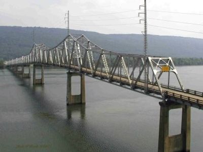
Comer Bridge, Road bridge in Scottsboro, Alabama, USA.

Description

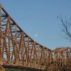
Comer Bridge was a road bridge crossing the Tennessee River near Scottsboro with steel Warren truss construction and two traffic lanes. It served as a major transportation link connecting communities and supporting regional commerce until its closure.

History

Built between 1929 and 1931 by the Kansas City Bridge Company, the bridge was named after Alabama's governor of that era. It closed in 2016 when a newer structure replaced its role on the highway.

Culture

The structure carried traffic through the region for decades, connecting communities on opposite sides of the river and shaping local travel patterns and commerce.

Practical

The bridge is no longer in service for traffic, having closed in 2016 and been removed from the river. Visitors interested in learning about it can find information through local historical resources and community records.

Did you know?

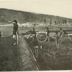
After its demolition, steel components from the structure were repurposed into a pyramid sculpture installed at Scottsboro High School. This artistic creation preserves the bridge's legacy in a unexpected way for the local community.

Location
Official opening
1931
GPS coordinates
34.64140,-85.97750
Latest update
December 13, 2025 11:44

AroundUs brings together thousands of curated places, local tips, and hidden gems, enriched daily by 60,000 contributors worldwide. Discover all places nearby (Alabama).

Around this place
Cathedral Caverns State Park
United States of America

Cathedral Caverns State Park

23.7 km
DeSoto State Park
United States of America

DeSoto State Park

36.7 km
Lake Guntersville State Park
United States of America

Lake Guntersville State Park

35.1 km
Buck's Pocket State Park
United States of America

Buck's Pocket State Park

19.7 km
Sauta Cave National Wildlife Refuge
United States of America

Sauta Cave National Wildlife Refuge

14.2 km
Fort Harker
United States of America

Fort Harker

28.7 km
Cherokee Plantation
United States of America

Cherokee Plantation

32.9 km
Old Union Crossing Covered Bridge
United States of America

Old Union Crossing Covered Bridge

36.7 km
W. B. Davis Hosiery Mill
United States of America

W. B. Davis Hosiery Mill

32.4 km
Winston Place
United States of America

Winston Place

34.3 km
Fort Payne Opera House
United States of America

Fort Payne Opera House

32.3 km
High Falls Park
United States of America

High Falls Park

28 km
Dancy-Polk House
United States of America

Dancy-Polk House

3.1 km
General William Rosecrans Headquarters
United States of America

General William Rosecrans Headquarters

28.9 km
Dr. J.A. Gorman House
United States of America

Dr. J.A. Gorman House

35.9 km
Vance C. Larmore House
United States of America

Vance C. Larmore House

31.8 km
Fort Payne Main Street Historic District
United States of America

Fort Payne Main Street Historic District

32.3 km
Fort Payne Boom Town Historic District
United States of America

Fort Payne Boom Town Historic District

32.3 km
Brown-Proctor House
United States of America

Brown-Proctor House

6.5 km
Skyline Commissary
United States of America

Skyline Commissary

23.3 km
Stevenson Historic District
United States of America

Stevenson Historic District

28.2 km
Fort Payne Residential Historic District
United States of America

Fort Payne Residential Historic District

32 km
Stephen's Gap Trail
United States of America

Stephen's Gap Trail

23 km
Henagar Drive-In
United States of America

Henagar Drive-In

25.1 km
DeKalb Theatre
United States of America

DeKalb Theatre

32.2 km
Neversink Pit
United States of America

Neversink Pit

17.9 km
John Snodgrass Bridge
United States of America

John Snodgrass Bridge

26.8 km
Mabrey's Rock of Ages
United States of America

Mabrey's Rock of Ages

35.7 km
Show the full map
« Comer Bridge - Road bridge in Scottsboro, Alabama, USA » is provided by Around Us (aroundus.com). Images and texts are derived from Wikimedia project under a Creative Commons license. You are allowed to copy, distribute, and modify copies of this page, under the conditions set by the license, as long as this note is clearly visible.

Discover hidden gems everywhere you go!

From secret cafés to breathtaking viewpoints, skip the crowded tourist spots and find places that match your style. Our app makes it easy with voice search, smart filtering, route optimization, and insider tips from travelers worldwide. Download now for the complete mobile experience.

Around Us App Screenshot

A unique approach to discovering new places

Le Figaro

All the places worth exploring

France Info

A tailor-made excursion in just a few clicks

20 Minutes

Around Us
Travel Guide & Maps
Download

Send to your phone

QR Code
1

Open the camera app on your mobile.

2

Point at the QR code with your camera. A notification will appear.

3

Tap the notification to open the link.