King Archaeological Site

Log in to your account

AroundUs is a community-driven map of interesting places, built by curious explorers like you. It grows with every review, story, and photo you share.
Connect to save your favorite spots, contribute locations, and create personalized routes.
Continue with Google
Continue with Apple
Continue with X
Continue with Facebook
Continue with email
By continuing, you accept our Terms and Conditions and our Privacy Policy
Create an account
Add to collection
Map
Suggest a change
Share

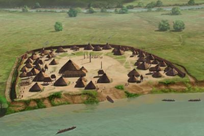
King Archaeological Site, Archaeological settlement from 16th century on Coosa River in Floyd County, Georgia, US.

King Archaeological Site is a 5-acre settlement with residential buildings, storage structures, and a central plaza ringed by defensive ditches and wooden walls. The layout includes carefully positioned living spaces such as semi-subterranean winter houses with peaked wooden roofs and lighter raised summer buildings used for storage and daily tasks.

The settlement developed during a period when Spanish expeditions were moving through the region, with evidence of contacts during Hernando de Soto's travels around 1540 and Tristan de Luna's journey approximately two decades later. This overlap shows how the community faced major disruptions in their world.

The central plaza served as the community's gathering place where important meetings took place and where people honored their dead according to their own beliefs. These burial practices reveal how residents understood kinship and their role within the group.

The site is best explored by starting at the central plaza and then viewing the surrounding residential areas to understand how people organized the space. The visible ditches and building foundations provide good clues about the original layout, even though only portions have been excavated.

Excavations uncovered European objects like iron tools and a sword in certain burials, suggesting early direct exchange between the community and Spanish expeditions. These finds are remarkable and provide rare archaeological evidence of these encounters.

Location: Georgia

GPS coordinates: 34.19180,-85.39770

Latest update: December 12, 2025 07:52

Photos
Around this place
Berry College
United States of America

Berry College

21.3 km
Weiss Lake
United States of America

Weiss Lake

21.5 km
James H. Floyd State Park
United States of America

James H. Floyd State Park

28.2 km
Oak Hill & The Martha Berry Museum
United States of America

Oak Hill & The Martha Berry Museum

22.2 km
Little River Falls
United States of America

Little River Falls

31 km
Chieftains Museum
United States of America

Chieftains Museum

23 km
Marshall Forest
United States of America

Marshall Forest

19.7 km
Clock Tower
United States of America

Clock Tower

22.1 km
Forum Civic Center
United States of America

Forum Civic Center

21.9 km
United States of America

Jackson Hill

23.1 km
Lumpkin Hill
United States of America

Lumpkin Hill

22.6 km
DeSoto Theatre
United States of America

DeSoto Theatre

22.2 km
United States Post Office and Courthouse
United States of America

United States Post Office and Courthouse

22 km
Old Shorter Hill
United States of America

Old Shorter Hill

22 km
Blossom Hill
United States of America

Blossom Hill

23.4 km
Sardis Presbyterian Church and Cemetery
United States of America

Sardis Presbyterian Church and Cemetery

8.4 km
Hawkes Children's Library
United States of America

Hawkes Children's Library

23.8 km
Between the Rivers Historic District
United States of America

Between the Rivers Historic District

21.9 km
Cedartown Commercial Historic District
United States of America

Cedartown Commercial Historic District

24 km
Chattooga County Courthouse
United States of America

Chattooga County Courthouse

32.4 km
Wesley O. Conner House
United States of America

Wesley O. Conner House

11.9 km
Cedartown Waterworks-Woman's Building-Big Spring Park Historic District
United States of America

Cedartown Waterworks-Woman's Building-Big Spring Park Historic District

23.5 km
Summerville Commercial Historic District
United States of America

Summerville Commercial Historic District

32.4 km
John M. Carroll House
United States of America

John M. Carroll House

11.3 km
Cave Spring Commercial Historic District
United States of America

Cave Spring Commercial Historic District

11 km
William D. Cowdry Plantation
United States of America

William D. Cowdry Plantation

10.1 km
Mushroom Rock
United States of America

Mushroom Rock

29.6 km
Movies at Mount Berry Square
United States of America

Movies at Mount Berry Square

24 km
Show the full map
Reviews

Visited this place? Tap the stars to rate it and share your experience / photos with the community! Try now! You can cancel it anytime.

« King Archaeological Site - Archaeological settlement from 16th century on Coosa River in Floyd County, Georgia, US » is provided by Around Us (aroundus.com). Images and texts are derived from Wikimedia project under a Creative Commons license. You are allowed to copy, distribute, and modify copies of this page, under the conditions set by the license, as long as this note is clearly visible.

Discover hidden gems everywhere you go!

From secret cafés to breathtaking viewpoints, skip the crowded tourist spots and find places that match your style. Our app makes it easy with voice search, smart filtering, route optimization, and insider tips from travelers worldwide. Download now for the complete mobile experience.

Around Us App Screenshot

A unique approach to discovering new places

Le Figaro

All the places worth exploring

France Info

A tailor-made excursion in just a few clicks

20 Minutes