·

Enable Location

We need your location to show you interesting places around you

Discover nearby places

Find interesting locations and hidden gems around you

Precise directions

Get accurate directions and distances to places

Your location is never shared with other users. It's only used when you tap the location button.

Marshall Forest

Log in to your account

Start exploring — it's free

Trusted by 62,654 travelers worldwide

Continue with Google
Continue with Apple
or

We will send you a code to connect

By continuing, you accept our Terms and Conditions and our Privacy Policy

Check your inbox

We've sent a pincode in your inbox. Please enter the code below.

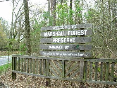
Marshall Forest, National Natural Landmark in Floyd County, Georgia.

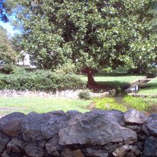
Marshall Forest is a National Natural Landmark in Floyd County that contains mixed pine and hardwood forests across a sizeable area. The property includes multiple distinct plant communities with more than 55 tree species growing at varying elevations.

The land was acquired by the Marshall family in 1880 after previously being part of Cherokee Nation territory. It became Georgia's first officially designated National Natural Landmark in 1966.

The forest reflects the efforts of local conservationists who work to maintain its native plant life and control invasive species. Visitors walking the trails can see signs of this stewardship in the well-marked paths and labeled trees throughout the property.

The property is open during daylight hours and features five marked walking trails on the southwest side with plant identification signs. Visitors should wear sturdy footwear and stay on marked paths since the terrain consists of natural forest ground.

The site is home to Georgia's largest population of an endangered wildflower that grows among its diverse trees and understory plants. This rare species was first documented by botanists exploring the property in the 1800s.

The community of curious travelers

AroundUs brings together thousands of curated places, local tips, and hidden gems, enriched daily by 60,000 contributors worldwide.

Start exploring
Location
GPS coordinates
34.25090,-85.19540
Latest update
December 8, 2025 21:08
Around this place
Berry College
United States of America

Berry College

6.5 km
James H. Floyd State Park
United States of America

James H. Floyd State Park

24.8 km
Oak Hill & The Martha Berry Museum
United States of America

Oak Hill & The Martha Berry Museum

3.2 km
King Archaeological Site
United States of America

King Archaeological Site

19.7 km
Chieftains Museum
United States of America

Chieftains Museum

3.7 km
Clock Tower
United States of America

Clock Tower

2.4 km
Euharlee Covered Bridge
United States of America

Euharlee Covered Bridge

27.2 km
Forum Civic Center
United States of America

Forum Civic Center

2.2 km
United States of America

Jackson Hill

3.4 km
Lumpkin Hill
United States of America

Lumpkin Hill

2.8 km
DeSoto Theatre
United States of America

DeSoto Theatre

2.5 km
United States Post Office and Courthouse
United States of America

United States Post Office and Courthouse

2.3 km
Old Shorter Hill
United States of America

Old Shorter Hill

2.4 km
Blossom Hill
United States of America

Blossom Hill

3.8 km
Sardis Presbyterian Church and Cemetery
United States of America

Sardis Presbyterian Church and Cemetery

16.9 km
Hawkes Children's Library
United States of America

Hawkes Children's Library

27.1 km
Between the Rivers Historic District
United States of America

Between the Rivers Historic District

2.3 km
Cedartown Commercial Historic District
United States of America

Cedartown Commercial Historic District

27.3 km
Wesley O. Conner House
United States of America

Wesley O. Conner House

20.9 km
Cedartown Waterworks-Woman's Building-Big Spring Park Historic District
United States of America

Cedartown Waterworks-Woman's Building-Big Spring Park Historic District

27 km
John M. Carroll House
United States of America

John M. Carroll House

21.2 km
Cave Spring Commercial Historic District
United States of America

Cave Spring Commercial Historic District

20.6 km
William D. Cowdry Plantation
United States of America

William D. Cowdry Plantation

19.8 km
Movies at Mount Berry Square
United States of America

Movies at Mount Berry Square

6.2 km
Adairsville Historic District
United States of America

Adairsville Historic District

27.3 km
Emmie Nelson Public Library
United States of America

Emmie Nelson Public Library

27 km
Euharlee History Museum
United States of America

Euharlee History Museum

26.5 km
Adairsville Public Library
United States of America

Adairsville Public Library

27.5 km
Show the full map
« Marshall Forest - National Natural Landmark in Floyd County, Georgia » is provided by Around Us (aroundus.com). Images and texts are derived from Wikimedia project under a Creative Commons license. You are allowed to copy, distribute, and modify copies of this page, under the conditions set by the license, as long as this note is clearly visible.

Discover hidden gems everywhere you go!

From secret cafés to breathtaking viewpoints, skip the crowded tourist spots and find places that match your style. Our app makes it easy with voice search, smart filtering, route optimization, and insider tips from travelers worldwide. Download now for the complete mobile experience.

Around Us App Screenshot

A unique approach to discovering new places

Le Figaro

All the places worth exploring

France Info

A tailor-made excursion in just a few clicks

20 Minutes

Around Us
Travel Guide & Maps
Download

Send to your phone

QR Code
1

Open the camera app on your mobile.

2

Point at the QR code with your camera. A notification will appear.

3

Tap the notification to open the link.