Lewis County

Log in to your account

AroundUs is a community-driven map of interesting places, built by curious explorers like you. It grows with every review, story, and photo you share.
Connect to save your favorite spots, contribute locations, and create personalized routes.
Continue with Google
Continue with Apple
Continue with X
Continue with Facebook
Continue with email
By continuing, you accept our Terms and Conditions and our Privacy Policy
Create an account
Add to collection
Map
Suggest a change
Share

Lewis County, County in Northeast Missouri, United States

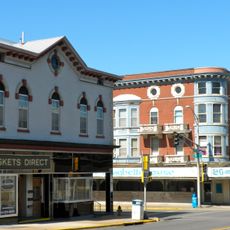
Lewis County is an administrative division in northeast Missouri that covers rolling terrain with farmland interspersed among small communities. Monticello serves as the county seat where government offices are located.

The county was established in 1833 and named after Meriwether Lewis, governor of the Louisiana Territory who led the expedition of exploration with William Clark. This connection links the region to early American westward exploration.

The county seat of Monticello sits at the heart of the region, where local life revolves around the courthouse and community gatherings that bring residents together throughout the year.

The best way to explore the region is to travel along the main roads connecting the various communities throughout the county. Monticello provides the central point for accessing services and information about the area.

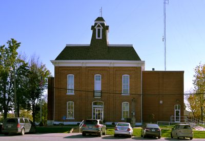
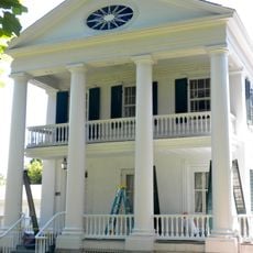
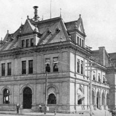
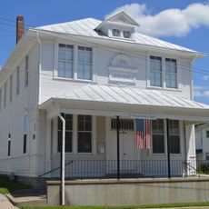
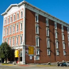
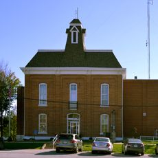
The courthouse built in 1875 in Monticello remains one of the few courthouses from that decade still operating in Missouri and stands as a prominent landmark. The structure reflects the craftsmanship and design of the period.

Location: Missouri

Inception: 1833

Capital city: Monticello

Shares border with: Clark County, Hancock County, Adams County, Marion County, Shelby County, Knox County

Website: http://lewiscountymo.org

GPS coordinates: 40.09000,-91.73000

Latest update: December 10, 2025 15:57

Photos
Around this place
Bayview Bridge
United States of America

Bayview Bridge

31.6 km
Quincy Memorial Bridge
United States of America

Quincy Memorial Bridge

31.7 km
Wakonda State Park
United States of America

Wakonda State Park

19.9 km
Downtown Quincy Historic District
United States of America

Downtown Quincy Historic District

32.5 km
Villa Kathrine
United States of America

Villa Kathrine

32.6 km
South Side German Historic District
United States of America

South Side German Historic District

33.3 km
Lock and Dam No. 20
United States of America

Lock and Dam No. 20

19.7 km
John Wood Mansion
United States of America

John Wood Mansion

33.8 km
Lock and Dam No. 21
United States of America

Lock and Dam No. 21

32.6 km
Woodland Cemetery
United States of America

Woodland Cemetery

33.2 km
Quincy Rail Bridge
United States of America

Quincy Rail Bridge

30.4 km
United States of America

Adams County Courthouse

32.4 km
Robert W. Gardner House
United States of America

Robert W. Gardner House

32.5 km
Morgan-Wells House
United States of America

Morgan-Wells House

32.6 km
Henderson Hall
United States of America

Henderson Hall

18.2 km
United States Post Office and Courthouse
United States of America

United States Post Office and Courthouse

32.9 km
Lincoln School
United States of America

Lincoln School

18.6 km
A.C. Waltman House
United States of America

A.C. Waltman House

20.3 km
Quincy Northwest Historic District
United States of America

Quincy Northwest Historic District

32.1 km
Ursa Town Hall
United States of America

Ursa Town Hall

31 km
State Savings Loan and Trust
United States of America

State Savings Loan and Trust

32.5 km
John McKoon House
United States of America

John McKoon House

20.1 km
S.J. Lesem Building
United States of America

S.J. Lesem Building

32.1 km
William Gray House
United States of America

William Gray House

20.1 km
Dr. J.A. Hay House
United States of America

Dr. J.A. Hay House

20.1 km
First Presbyterian Church
United States of America

First Presbyterian Church

20.1 km
One Thirty North Eighth Building
United States of America

One Thirty North Eighth Building

32.9 km
Lewis County Courthouse
United States of America

Lewis County Courthouse

3.4 km
Show the full map
Reviews

Visited this place? Tap the stars to rate it and share your experience / photos with the community! Try now! You can cancel it anytime.

Administrative divisions
« Lewis County - County in Northeast Missouri, United States » is provided by Around Us (aroundus.com). Images and texts are derived from Wikimedia project under a Creative Commons license. You are allowed to copy, distribute, and modify copies of this page, under the conditions set by the license, as long as this note is clearly visible.

Discover hidden gems everywhere you go!

From secret cafés to breathtaking viewpoints, skip the crowded tourist spots and find places that match your style. Our app makes it easy with voice search, smart filtering, route optimization, and insider tips from travelers worldwide. Download now for the complete mobile experience.

Around Us App Screenshot

A unique approach to discovering new places

Le Figaro

All the places worth exploring

France Info

A tailor-made excursion in just a few clicks

20 Minutes