Chest opened
+${chestReward.xp} XP
Explorer
NOUVEAU ×${chestReward.collectible.quantity}
tapez pour fermer
Chest locked

Open chests in the app

Around Us is built for your phone — chests unlock when you walk, explore and capture nearby places.

Enable Location

We need your location to show you interesting places around you

Discover nearby places

Find interesting locations and hidden gems around you

Precise directions

Get accurate directions and distances to places

Your location is never shared with other users. It's only used when you tap the location button.

Log in to your account

Start exploring — it's free

Trusted by 72,984 travelers worldwide

Continue with Google
Continue with Apple
or

We will send you a code to connect

By continuing, you accept our Terms and Conditions and our Privacy Policy

Check your inbox

We've sent a pincode in your inbox. Please enter the code below.

Island Number Ten
Discussion Reviews Photo
4.2k Popularity

Island Number Ten, River island in Mississippi River near Tiptonville, Tennessee, United States.

Island Number Ten is a river island in the Mississippi River near Tiptonville, Tennessee. The island sits in a section of the river that once played a role in controlling water traffic moving downstream.

During the American Civil War in 1862, the island became the site of a major military battle. Union forces then took control of this strategic stretch of the river and blocked Confederate supply routes.

The numbering system of Mississippi River islands represented the federal government's initiative to establish clear geographical identification for navigation purposes.

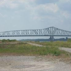
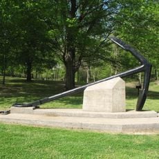
The site is accessible by land today, with a monument viewable from State Route 22 north of Tiptonville. Visit outside flood season in spring for the clearest view of the landscape.

The river has significantly reshaped the original island through natural erosion, and it largely disappeared over time. What was once a distinct landform is now merged into the wide floodplain of the Mississippi.

The community of curious travelers

AroundUs brings together thousands of curated places, local tips, and hidden gems, enriched daily by 60,000 contributors worldwide.

Start exploring
Location
GPS coordinates
36.44828,-89.46828
Latest update
December 21, 2025 16:05
Around this place
Reelfoot Lake
United States of America

Reelfoot Lake

10.9 km
Reelfoot Lake State Park
United States of America

Reelfoot Lake State Park

10 km
Caruthersville Bridge
United States of America

Caruthersville Bridge

39.3 km
Columbus-Belmont State Park
United States of America

Columbus-Belmont State Park

47.9 km
Big Oak Tree State Park
United States of America

Big Oak Tree State Park

26.2 km
Towosahgy State Historic Site
United States of America

Towosahgy State Historic Site

34.3 km
Murphy Mound Archeological Site
United States of America

Murphy Mound Archeological Site

38.6 km
Confederate Monument
United States of America

Confederate Monument

37.8 km
Confederate Memorial Gateway in Hickman
United States of America

Confederate Memorial Gateway in Hickman

28.7 km
Thomas Chapel C.M.E. Church
United States of America

Thomas Chapel C.M.E. Church

28.5 km
Mt. Zion Colored Methodist Episcopal Church
United States of America

Mt. Zion Colored Methodist Episcopal Church

38 km
Edward Moody King House
United States of America

Edward Moody King House

46.6 km
Obion County Courthouse
United States of America

Obion County Courthouse

36.7 km
Caruthersville Water Tower
United States of America

Caruthersville Water Tower

33 km
Hickman County Courthouse
United States of America

Hickman County Courthouse

48.9 km
Charles and Bettie Birthright House
United States of America

Charles and Bettie Birthright House

44.7 km
Bank of Dyersburg
United States of America

Bank of Dyersburg

46.9 km
Houser House
United States of America

Houser House

35.6 km
Thomas Leroy Bransford House
United States of America

Thomas Leroy Bransford House

37.6 km
Sikeston St. Louis, Iron Mountain and Southern Railway Depot
United States of America

Sikeston St. Louis, Iron Mountain and Southern Railway Depot

48.9 km
Carnegie Library
United States of America

Carnegie Library

28.7 km
Caldwell-Hopson House
United States of America

Caldwell-Hopson House

8.1 km
Reelfoot Lake State Park Visitor Center
United States of America

Reelfoot Lake State Park Visitor Center

10 km
Deering Building
United States of America

Deering Building

36.9 km
River City Adventure Park
United States of America

River City Adventure Park

32.8 km
Hunter-Dawson State Historic Site
United States of America

Hunter-Dawson State Historic Site

17.2 km
Masquerade Theatre
United States of America

Masquerade Theatre

36.9 km
Splash Pad
United States of America

Splash Pad

38.9 km
Show the full map
Reviews
Share your experience

No review yet

Discussions
Start a discussion...

No discussion yet

« Island Number Ten - River island in Mississippi River near Tiptonville, Tennessee, United States » is provided by Around Us (aroundus.com). Images and texts are derived from Wikimedia project under a Creative Commons license. You are allowed to copy, distribute, and modify copies of this page, under the conditions set by the license, as long as this note is clearly visible.

Discover hidden gems everywhere you go!

From secret cafés to breathtaking viewpoints, skip the crowded tourist spots and find places that match your style. Our app makes it easy with voice search, smart filtering, route optimization, and insider tips from travelers worldwide. Download now for the complete mobile experience.

Around Us App Screenshot

A unique approach to discovering new places

Le Figaro

All the places worth exploring

France Info

A tailor-made excursion in just a few clicks

20 Minutes

Around Us
Travel Guide & Maps
Download

Send to your phone

QR Code
1

Open the camera app on your mobile.

2

Point at the QR code with your camera. A notification will appear.

3

Tap the notification to open the link.