Chest opened
+${chestReward.xp} XP
Explorer
NOUVEAU ×${chestReward.collectible.quantity}
tapez pour fermer
Chest locked

Open chests in the app

Around Us is built for your phone — chests unlock when you walk, explore and capture nearby places.

Enable Location

We need your location to show you interesting places around you

Discover nearby places

Find interesting locations and hidden gems around you

Precise directions

Get accurate directions and distances to places

Your location is never shared with other users. It's only used when you tap the location button.

Butcher Hollow

Log in to your account

Start exploring — it's free

Trusted by 72,950 travelers worldwide

Continue with Google
Continue with Apple
or

We will send you a code to connect

By continuing, you accept our Terms and Conditions and our Privacy Policy

Check your inbox

We've sent a pincode in your inbox. Please enter the code below.

Discussion Reviews 2 Photos
96.9k Popularity

Butcher Hollow, Rural community in Johnson County, Kentucky

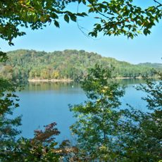
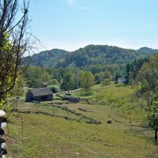
Butcher Hollow is a rural settlement in Johnson County, eastern Kentucky, tucked among wooded hills and narrow valleys. The community sits away from major roads and features small houses scattered along a narrow creek.

The settlement took shape in the early 20th century as coal mining drew families into the narrow valleys of the region. Many residents worked in nearby mines until extraction gradually declined and the population shrank.

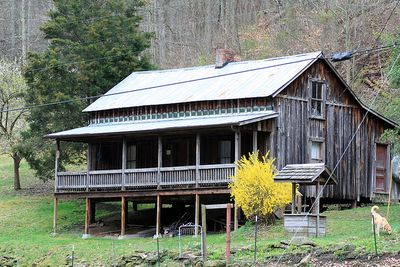
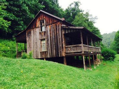
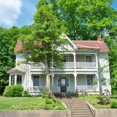
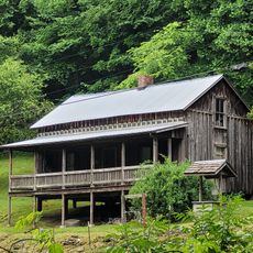
The birthplace of singer Loretta Lynn carries the nickname "Butcher Holler" in local speech and appears in many of her songs about mountain life. Visitors see the small wooden house where her family lived, now preserved as a reminder of childhood in a mining community.

Visitors reach the community via rural roads that wind through wooded terrain and occasionally narrow. The nearest gas stations, shops and lodging lie several miles away in larger towns.

The singer's family house later became an attraction after her autobiography and songs brought attention to the region. Visitors also see a small store from the mining era that retains its original setup.

The community of curious travelers

AroundUs brings together thousands of curated places, local tips, and hidden gems, enriched daily by 60,000 contributors worldwide.

Start exploring
Location
GPS coordinates
37.77800,-82.71700
Latest update
December 12, 2025 23:38
Around this place
United States of America

Eastern Kentucky Coal Field region

32.4 km
Jenny Wiley State Resort Park
United States of America

Jenny Wiley State Resort Park

9 km
U.S. 23 Country Music Highway Museum
United States of America

U.S. 23 Country Music Highway Museum

11.9 km
Dewey Lake
United States of America

Dewey Lake

4.8 km
Paintsville Lake
United States of America

Paintsville Lake

17.8 km
Mayo Mansion
United States of America

Mayo Mansion

9.1 km
Paintsville Lake State Park
United States of America

Paintsville Lake State Park

15.2 km
Yatesville Lake State Park
United States of America

Yatesville Lake State Park

34.3 km
Mountain Homeplace
United States of America

Mountain Homeplace

15.4 km
East Kentucky Science Center
United States of America

East Kentucky Science Center

11.7 km
Francis M. Stafford House
United States of America

Francis M. Stafford House

8.7 km
Samuel May House
United States of America

Samuel May House

12.1 km
Magoffin County Pioneer Village and Museum
United States of America

Magoffin County Pioneer Village and Museum

31 km
First United Methodist Church
United States of America

First United Methodist Church

9 km
Johnson County Public Library
United States of America

Johnson County Public Library

8.9 km
Salyersville National Bank
United States of America

Salyersville National Bank

31.1 km
David McKenzie Log Cabin
United States of America

David McKenzie Log Cabin

20.7 km
Martin Himler House
United States of America

Martin Himler House

25.4 km
First National Bank Building
United States of America

First National Bank Building

8.7 km
Methodist Episcopal Church, South
United States of America

Methodist Episcopal Church, South

13.5 km
Paintsville City Hall
United States of America

Paintsville City Hall

8.6 km
Paintsville Public Library Building
United States of America

Paintsville Public Library Building

8.9 km
Foster Hardware
United States of America

Foster Hardware

659 m
H.B. Rice Insurance Building
United States of America

H.B. Rice Insurance Building

8.8 km
Front Street Historic District
United States of America

Front Street Historic District

13.4 km
Martin County Courthouse
United States of America

Martin County Courthouse

18.5 km
Fitzpatrick-Harmon House
United States of America

Fitzpatrick-Harmon House

13.1 km
Loretta Lynn's Homeplace
United States of America

Loretta Lynn's Homeplace

1.3 km
Show the full map
Reviews
Share your experience

No review yet

Discussions
Start a discussion...

No discussion yet

« Butcher Hollow - Rural community in Johnson County, Kentucky » is provided by Around Us (aroundus.com). Images and texts are derived from Wikimedia project under a Creative Commons license. You are allowed to copy, distribute, and modify copies of this page, under the conditions set by the license, as long as this note is clearly visible.

Discover hidden gems everywhere you go!

From secret cafés to breathtaking viewpoints, skip the crowded tourist spots and find places that match your style. Our app makes it easy with voice search, smart filtering, route optimization, and insider tips from travelers worldwide. Download now for the complete mobile experience.

Around Us App Screenshot

A unique approach to discovering new places

Le Figaro

All the places worth exploring

France Info

A tailor-made excursion in just a few clicks

20 Minutes

Around Us
Travel Guide & Maps
Download

Send to your phone

QR Code
1

Open the camera app on your mobile.

2

Point at the QR code with your camera. A notification will appear.

3

Tap the notification to open the link.