Enable Location

We need your location to show you interesting places around you

Discover nearby places

Find interesting locations and hidden gems around you

Precise directions

Get accurate directions and distances to places

Your location is never shared with other users. It's only used when you tap the location button.

Log in to your account

Start exploring — it's free

Trusted by 68,264 travelers worldwide

Continue with Google
Continue with Apple
or

We will send you a code to connect

By continuing, you accept our Terms and Conditions and our Privacy Policy

Check your inbox

We've sent a pincode in your inbox. Please enter the code below.

Fort Bennett
Discussion Reviews Photo
3k Popularity

Fort Bennett, Military fort in Stanley County, South Dakota.

Fort Bennett was a military post built at the junction of the Cheyenne River and the Missouri River, featuring barracks, officer residences, and storage structures made from cottonwood logs. The compound included a hospital, guard houses, and administrative buildings spread across the site.

The post was established in 1870 to serve as a control center for Sioux tribes in the region. It was renamed in 1878 to honor Captain Andrew Bennett, who had died in conflict with Bannock Indians, and closed in 1891.

The fort managed resources and administration for Minneconjou, Sans Arc, and Two Kettle tribes, supporting between 1,500 and 7,000 Native American residents.

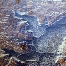
The site now lies submerged beneath Lake Oahe, created when the Oahe Dam was built in the early 1960s. Visitors cannot see physical remains on the ground because the entire location is underwater.

The site originally bore the name Post at Cheyenne River Agency before its renaming in 1878. This detail reveals how the location's designation reflected its administrative purpose at that time.

The community of curious travelers

AroundUs brings together thousands of curated places, local tips, and hidden gems, enriched daily by 60,000 contributors worldwide.

Start exploring
Location
Inception
1870
GPS coordinates
44.67170,-100.64100
Latest update
December 12, 2025 12:03
Around this place
Lake Oahe
United States of America

Lake Oahe

31 km
South Dakota Governor's Residence
United States of America

South Dakota Governor's Residence

41.6 km
South Dakota State Capitol
United States of America

South Dakota State Capitol

41.2 km
Pierre Shale
Canada

Pierre Shale

35.8 km
Fort Pierre Chouteau
United States of America

Fort Pierre Chouteau

37.2 km
Verendrye Site
United States of America

Verendrye Site

40.9 km
Chicago and North Western Railroad Bridge
United States of America

Chicago and North Western Railroad Bridge

39.5 km
Hughes County Courthouse
United States of America

Hughes County Courthouse

40.8 km
I. W. Goodner House
United States of America

I. W. Goodner House

39.9 km
Peter Hansen House
United States of America

Peter Hansen House

41.1 km
Farr House
United States of America

Farr House

40.7 km
G.L. Stocker Blacksmith Shop
United States of America

G.L. Stocker Blacksmith Shop

65.9 km
Dr. William and Elizabeth Blackburn House
United States of America

Dr. William and Elizabeth Blackburn House

42.5 km
Dakota Club Library
United States of America

Dakota Club Library

59.4 km
Pierre Masonic Lodge
United States of America

Pierre Masonic Lodge

22.5 km
Fort Pierre Congregational Church
United States of America

Fort Pierre Congregational Church

41.2 km
Brink-Wegner House
United States of America

Brink-Wegner House

40 km
Laurens Polygonal Hog House
United States of America

Laurens Polygonal Hog House

56.8 km
Sully County Courthouse
United States of America

Sully County Courthouse

45.7 km
Karcher–Sahr House
United States of America

Karcher–Sahr House

41 km
L.E. Snyder House
United States of America

L.E. Snyder House

45.7 km
John E. and Ruth Hipple House
United States of America

John E. and Ruth Hipple House

40.9 km
Jefferson Davis Carr House
United States of America

Jefferson Davis Carr House

41.1 km
Crawford–Pettyjohn House
United States of America

Crawford–Pettyjohn House

42 km
Horner–Hyde House
United States of America

Horner–Hyde House

40.8 km
Methodist Episcopal Church
United States of America

Methodist Episcopal Church

40.5 km
LaFramboise Island Nature Area
United States of America

LaFramboise Island Nature Area

42.8 km
Okobojo Point Recreation Area
United States of America

Okobojo Point Recreation Area

15.4 km
Show the full map
Reviews
Share your experience

No review yet

Discussions
Start a discussion...

No discussion yet

« Fort Bennett - Military fort in Stanley County, South Dakota » is provided by Around Us (aroundus.com). Images and texts are derived from Wikimedia project under a Creative Commons license. You are allowed to copy, distribute, and modify copies of this page, under the conditions set by the license, as long as this note is clearly visible.

Discover hidden gems everywhere you go!

From secret cafés to breathtaking viewpoints, skip the crowded tourist spots and find places that match your style. Our app makes it easy with voice search, smart filtering, route optimization, and insider tips from travelers worldwide. Download now for the complete mobile experience.

Around Us App Screenshot

A unique approach to discovering new places

Le Figaro

All the places worth exploring

France Info

A tailor-made excursion in just a few clicks

20 Minutes

Around Us
Travel Guide & Maps
Download

Send to your phone

QR Code
1

Open the camera app on your mobile.

2

Point at the QR code with your camera. A notification will appear.

3

Tap the notification to open the link.