Enable Location

We need your location to show you interesting places around you

Discover nearby places

Find interesting locations and hidden gems around you

Precise directions

Get accurate directions and distances to places

Your location is never shared with other users. It's only used when you tap the location button.

Log in to your account

Start exploring — it's free

Trusted by 62,934 travelers worldwide

Continue with Google
Continue with Apple
or

We will send you a code to connect

By continuing, you accept our Terms and Conditions and our Privacy Policy

Check your inbox

We've sent a pincode in your inbox. Please enter the code below.

Fort Meadow Reservoir
Discussion Reviews Photo
2.9k Popularity

Fort Meadow Reservoir, body of water

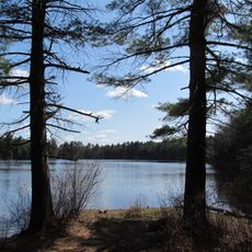
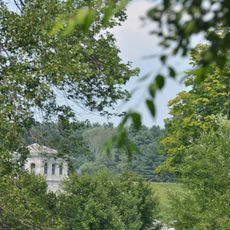
Fort Meadow Reservoir is a large body of water in Massachusetts covering about 260 acres, divided into two sections connected by a narrow channel. The water averages about 9 feet (2.7 meters) deep and stretches over a mile, with two public beaches serving visitors from the bordering towns of Marlborough and Hudson.

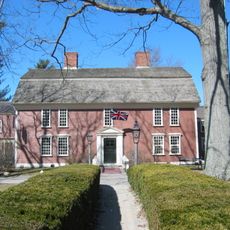
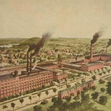
The water became part of local history when Amory Maynard built a sawmill on its flow in the 1800s, leading to the founding of the town of Maynard and early industrial development. Boston later purchased water rights from the reservoir, establishing its role as a key regional resource.

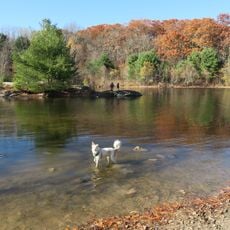
The location is easy to reach from nearby roads with parking available, and walking or biking paths lead directly to the water's edge for convenient access. The two public beaches offer straightforward entry for swimming, boating, and outdoor recreation during warmer seasons.

A road runs directly through the primary basin dividing it into two sections, an unusual feature that allows vehicle traffic while keeping recreational areas separate. This arrangement creates a distinctive layout not commonly found in most reservoirs.

The community of curious travelers

AroundUs brings together thousands of curated places, local tips, and hidden gems, enriched daily by 60,000 contributors worldwide.

Start exploring
Location
GPS coordinates
42.36840,-71.54540
Latest update
February 9, 2026 08:23
Around this place
American Heritage Museum
United States of America

American Heritage Museum

4.8 km
Collings Foundation
United States of America

Collings Foundation

5 km
New England Sports Center
United States of America

New England Sports Center

4.2 km
Wayside Inn Historic District
United States of America

Wayside Inn Historic District

6.5 km
Assabet River National Wildlife Refuge
United States of America

Assabet River National Wildlife Refuge

7.6 km
United States of America

Assabet River Rail Trail

2.7 km
Callahan State Park
United States of America

Callahan State Park

8.5 km
Nobscot Hill
United States of America

Nobscot Hill

8.3 km
Firestone-Apsley Rubber Company
United States of America

Firestone-Apsley Rubber Company

3.9 km
United States of America

John J. Carroll Water Treatment Plant

6.9 km
Sudbury Dam Historic District
United States of America

Sudbury Dam Historic District

8.3 km
Bullard House
United States of America

Bullard House

7.7 km
Goodale Homestead
United States of America

Goodale Homestead

3.6 km
J.D.C. Bradley House
United States of America

J.D.C. Bradley House

5.8 km
Paul Gibbs House
United States of America

Paul Gibbs House

6.8 km
Marlborough Center Historic District
United States of America

Marlborough Center Historic District

2.3 km
Capt. Peter Rice House
United States of America

Capt. Peter Rice House

3.4 km
Hapgood House
United States of America

Hapgood House

6.5 km
Berlin Town Hall
United States of America

Berlin Town Hall

7.7 km
Col. Adelbert Mossman House
United States of America

Col. Adelbert Mossman House

3.1 km
American Heritage Museum
United States of America

American Heritage Museum

4.2 km
John Cotting House
United States of America

John Cotting House

2.4 km
Pleasant Street Historic District
United States of America

Pleasant Street Historic District

2.6 km
West Main Street Historic District
United States of America

West Main Street Historic District

2.9 km
Brown-Stow House
United States of America

Brown-Stow House

8 km
Bolton Center Historic District
United States of America

Bolton Center Historic District

8.8 km
Pan Historic District
United States of America

Pan Historic District

7.2 km
Randall-Hale Homestead
United States of America

Randall-Hale Homestead

4.7 km
Show the full map
Reviews
Share your experience

No review yet

Discussions
Start a discussion...

No discussion yet

« Fort Meadow Reservoir - body of water » is provided by Around Us (aroundus.com). Images and texts are derived from Wikimedia project under a Creative Commons license. You are allowed to copy, distribute, and modify copies of this page, under the conditions set by the license, as long as this note is clearly visible.

Discover hidden gems everywhere you go!

From secret cafés to breathtaking viewpoints, skip the crowded tourist spots and find places that match your style. Our app makes it easy with voice search, smart filtering, route optimization, and insider tips from travelers worldwide. Download now for the complete mobile experience.

Around Us App Screenshot

A unique approach to discovering new places

Le Figaro

All the places worth exploring

France Info

A tailor-made excursion in just a few clicks

20 Minutes

Around Us
Travel Guide & Maps
Download

Send to your phone

QR Code
1

Open the camera app on your mobile.

2

Point at the QR code with your camera. A notification will appear.

3

Tap the notification to open the link.