Enable Location

We need your location to show you interesting places around you

Discover nearby places

Find interesting locations and hidden gems around you

Precise directions

Get accurate directions and distances to places

Your location is never shared with other users. It's only used when you tap the location button.

Log in to your account

Start exploring — it's free

Trusted by 68,040 travelers worldwide

Continue with Google
Continue with Apple
or

We will send you a code to connect

By continuing, you accept our Terms and Conditions and our Privacy Policy

Check your inbox

We've sent a pincode in your inbox. Please enter the code below.

Fort Renville
Discussion Reviews Photo
1.6k Popularity

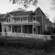
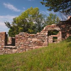
Fort Renville, Fur trading fort in Lac qui Parle State Park, Minnesota, US.

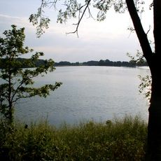
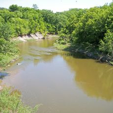
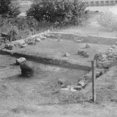
Fort Renville is a fur trading post near the Minnesota River in Lac qui Parle State Park. Today you can see remains of wooden palisades, a watchtower, and the foundations of four original buildings that once made up the trading settlement.

The Columbia Fur Company established this post in 1826 under Joseph Renville's leadership as a hub for the booming fur trade. Later, the American Fur Company took control and expanded operations across the northern territories.

The fort served as a gathering point where French-Canadian traders and Dakota people exchanged goods and shared daily routines. This interaction shaped how both groups lived and worked in the Minnesota Territory during the fur trade era.

The ruins sit within Lac qui Parle State Park, where you can reach them via marked trails and pathways. Interpretive signs along the route explain the fort's story and what the original structures looked like during its working years.

Digging campaigns in the 1940s and 1960s uncovered roughly 50 objects left behind from daily life at the trading post, including tools, pottery shards, and personal items. These discoveries give visitors a tangible sense of what people actually used and owned during those earlier decades.

The community of curious travelers

AroundUs brings together thousands of curated places, local tips, and hidden gems, enriched daily by 60,000 contributors worldwide.

Start exploring
GPS coordinates
45.03240,-95.87850
Latest update
December 14, 2025 14:25
Around this place
Upper Sioux Agency State Park
United States of America

Upper Sioux Agency State Park

47 km
Andrew John Volstead House
United States of America

Andrew John Volstead House

36.5 km
Monson Lake State Park
United States of America

Monson Lake State Park

57.5 km
Lac qui Parle State Park
United States of America

Lac qui Parle State Park

1 km
Lac qui Parle Mission
United States of America

Lac qui Parle Mission

1.6 km
Camp Release State Monument
United States of America

Camp Release State Monument

15.1 km
Big Stone National Wildlife Refuge
United States of America

Big Stone National Wildlife Refuge

43.6 km
Church of St. Bridget-Catholic
United States of America

Church of St. Bridget-Catholic

40.9 km
Sacred Heart Public School
United States of America

Sacred Heart Public School

50 km
Swift County Courthouse
United States of America

Swift County Courthouse

38.4 km
Church of St. Francis Xavier
United States of America

Church of St. Francis Xavier

38.7 km
Gethsemane Episcopal Church
United States of America

Gethsemane Episcopal Church

21.7 km
Lund–Hoel House
United States of America

Lund–Hoel House

47.4 km
St. Paul's Evangelical Lutheran Church & Parsonage
United States of America

St. Paul's Evangelical Lutheran Church & Parsonage

53.4 km
Big Stone County Courthouse
United States of America

Big Stone County Courthouse

53.7 km
Christ Episcopal Church
United States of America

Christ Episcopal Church

38.4 km
Appleton City Hall
United States of America

Appleton City Hall

21.7 km
Madison Carnegie Library
United States of America

Madison Carnegie Library

24.9 km
Dawson Bank Museum
United States of America

Dawson Bank Museum

18 km
Sabin S. Murdock House
United States of America

Sabin S. Murdock House

43.9 km
Canby Commercial Historic District
United States of America

Canby Commercial Historic District

47.7 km
Fagen Fighters WWII Museum
United States of America

Fagen Fighters WWII Museum

40.2 km
First State Bank Building
United States of America

First State Bank Building

54.5 km
Milan Bridge
United States of America

Milan Bridge

10.8 km
Lac Qui Parle County Courthouse
United States of America

Lac Qui Parle County Courthouse

24.8 km
Monson Lake State Park CCC/WPA/Rustic Style Historic Resources
United States of America

Monson Lake State Park CCC/WPA/Rustic Style Historic Resources

57.2 km
Lou T. Fisk
United States of America

Lou T. Fisk

25.1 km
Joseph Brown House Ruins
United States of America

Joseph Brown House Ruins

57.6 km
Show the full map
Reviews
Share your experience

No review yet

Discussions
Start a discussion...

No discussion yet

« Fort Renville - Fur trading fort in Lac qui Parle State Park, Minnesota, US » is provided by Around Us (aroundus.com). Images and texts are derived from Wikimedia project under a Creative Commons license. You are allowed to copy, distribute, and modify copies of this page, under the conditions set by the license, as long as this note is clearly visible.

Discover hidden gems everywhere you go!

From secret cafés to breathtaking viewpoints, skip the crowded tourist spots and find places that match your style. Our app makes it easy with voice search, smart filtering, route optimization, and insider tips from travelers worldwide. Download now for the complete mobile experience.

Around Us App Screenshot

A unique approach to discovering new places

Le Figaro

All the places worth exploring

France Info

A tailor-made excursion in just a few clicks

20 Minutes

Around Us
Travel Guide & Maps
Download

Send to your phone

QR Code
1

Open the camera app on your mobile.

2

Point at the QR code with your camera. A notification will appear.

3

Tap the notification to open the link.