Enable Location

We need your location to show you interesting places around you

Discover nearby places

Find interesting locations and hidden gems around you

Precise directions

Get accurate directions and distances to places

Your location is never shared with other users. It's only used when you tap the location button.

Foxborough State Hospital

Log in to your account

Start exploring — it's free

Trusted by 65,904 travelers worldwide

Continue with Google
Continue with Apple
or

We will send you a code to connect

By continuing, you accept our Terms and Conditions and our Privacy Policy

Check your inbox

We've sent a pincode in your inbox. Please enter the code below.

Discussion Reviews 1 Photos
3.2k Popularity

Foxborough State Hospital, Historic medical district in Foxborough, Massachusetts

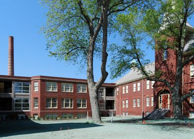
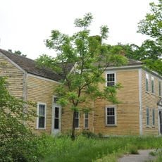
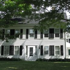
Foxborough State Hospital is a former psychiatric and addiction treatment facility in Foxborough, Massachusetts, made up of brick residential wards arranged in an L shape around a central administration building. Several of the original structures have since been converted into mixed-income housing and a shopping area, while others remain empty.

The complex opened in 1889 as the first state-run facility in the United States dedicated solely to treating alcoholism, a role that set a precedent for how public institutions handled addiction. It remained in operation until 1975, after which the buildings gradually changed purpose.

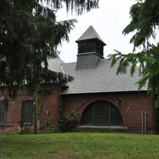
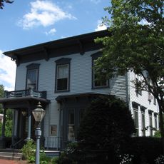
The brick buildings follow an English Queen Anne revival style mixed with American colonial forms, which gives the complex a residential rather than institutional look. This choice was deliberate: late 19th-century designers wanted patients to feel they were living in a home, not confined in a facility.

Much of the site is now private property, so visitors can generally only view the exterior of the buildings from public paths or roads. It helps to look up current access conditions before arriving, as open areas may vary.

The facility had a morgue built to hold eight bodies at once, which was unusually large for an institution of its type and reflects the high mortality rate among patients during that era. This morgue remained in use throughout the hospital's entire active period.

The community of curious travelers

AroundUs brings together thousands of curated places, local tips, and hidden gems, enriched daily by 60,000 contributors worldwide.

Start exploring
Location
GPS coordinates
42.07806,-71.25833
Latest update
March 3, 2026 13:54
Around this place
Gillette Stadium
United States of America

Gillette Stadium

1.5 km
United States of America

Foxboro Stadium

1.8 km
Moose Hill Wildlife Sanctuary
United States of America

Moose Hill Wildlife Sanctuary

6.4 km
F. Gilbert Hills State Forest
United States of America

F. Gilbert Hills State Forest

3.1 km
Moose Hill Farm
United States of America

Moose Hill Farm

6.8 km
Warner Trail
United States of America

Warner Trail

6.9 km
Memorial Hall
United States of America

Memorial Hall

1.7 km
Walpole Town Hall
United States of America

Walpole Town Hall

7.6 km
Warelands
United States of America

Warelands

7.6 km
Foxboro Grange Hall
United States of America

Foxboro Grange Hall

1.5 km
Norfolk Grange Hall
United States of America

Norfolk Grange Hall

7.9 km
Fisher-Richardson House
United States of America

Fisher-Richardson House

7.9 km
Sharon Historic District
United States of America

Sharon Historic District

8.3 km
Amos Morse House
United States of America

Amos Morse House

711 m
Original Congregational Church of Wrentham
United States of America

Original Congregational Church of Wrentham

5.8 km
Stoughtonham Furnace Site
United States of America

Stoughtonham Furnace Site

3.8 km
Foxborough Pumping Station
United States of America

Foxborough Pumping Station

1.7 km
Seth Boyden House
United States of America

Seth Boyden House

3.4 km
Charles R. Wilber School
United States of America

Charles R. Wilber School

8 km
Ezra Carpenter House
United States of America

Ezra Carpenter House

2.9 km
Otis Cary House
United States of America

Otis Cary House

3.7 km
Sullivan's Corner Historic District
United States of America

Sullivan's Corner Historic District

6.4 km
Capt. Josiah Pratt House
United States of America

Capt. Josiah Pratt House

5 km
Roebuck Tavern
United States of America

Roebuck Tavern

5.9 km
Rockwood Road Historic District
United States of America

Rockwood Road Historic District

7.5 km
Soldiers' Memorial Library
United States of America

Soldiers' Memorial Library

7 km
Deacon Willard Lewis House
United States of America

Deacon Willard Lewis House

7.5 km
Plimpton-Winter House
United States of America

Plimpton-Winter House

6.2 km
Show the full map
Reviews
Share your experience

No review yet

Discussions
Start a discussion...

No discussion yet

« Foxborough State Hospital - Historic medical district in Foxborough, Massachusetts » is provided by Around Us (aroundus.com). Images and texts are derived from Wikimedia project under a Creative Commons license. You are allowed to copy, distribute, and modify copies of this page, under the conditions set by the license, as long as this note is clearly visible.

Discover hidden gems everywhere you go!

From secret cafés to breathtaking viewpoints, skip the crowded tourist spots and find places that match your style. Our app makes it easy with voice search, smart filtering, route optimization, and insider tips from travelers worldwide. Download now for the complete mobile experience.

Around Us App Screenshot

A unique approach to discovering new places

Le Figaro

All the places worth exploring

France Info

A tailor-made excursion in just a few clicks

20 Minutes

Around Us
Travel Guide & Maps
Download

Send to your phone

QR Code
1

Open the camera app on your mobile.

2

Point at the QR code with your camera. A notification will appear.

3

Tap the notification to open the link.