Enable Location

We need your location to show you interesting places around you

Discover nearby places

Find interesting locations and hidden gems around you

Precise directions

Get accurate directions and distances to places

Your location is never shared with other users. It's only used when you tap the location button.

Fort Hartsuff State Historical Park

Log in to your account

Start exploring — it's free

Trusted by 61,536 travelers worldwide

Continue with Google
Continue with Apple
or

We will send you a code to connect

By continuing, you accept our Terms and Conditions and our Privacy Policy

Check your inbox

We've sent a pincode in your inbox. Please enter the code below.

Fort Hartsuff State Historical Park

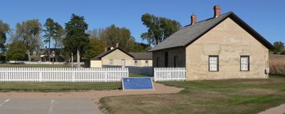
Fort Hartsuff State Historical Park, Historical military park in Valley County, Nebraska, US.

Description

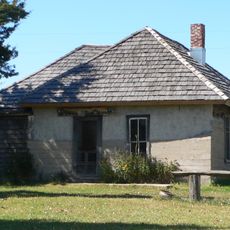
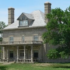
Fort Hartsuff State Historical Park is a military installation with original limestone buildings from the 1870s. The structures include officers' residences, soldier barracks, a guardhouse, and support buildings that reveal how frontier troops lived and worked.

History

The fort was established in 1874 and operated until 1881 as a military outpost on the frontier. During its active years, it served as a key location for managing territorial relations and protecting settlers moving into the region.

Culture

The fort served as a military hub in a frontier setting where soldiers and settlers intersected. Visitors walking through the grounds can observe how daily life unfolded in this remote outpost during the late 1800s.

Practical

The grounds are open during daylight hours and visitors should wear sturdy footwear as the terrain is uneven. Many buildings can be viewed from the outside, while some interiors are accessible depending on the season.

Did you know?

The limestone buildings remain arranged as they were originally configured, offering a rare complete view of how a military frontier post actually looked. Most forts from this era were either dismantled or heavily altered, making this layout particularly exceptional.

Location
Inception
1961
GPS coordinates
41.72350,-99.02360
Latest update
December 14, 2025 09:44

AroundUs brings together thousands of curated places, local tips, and hidden gems, enriched daily by 60,000 contributors worldwide. Discover all places nearby (Valley County).

Around this place
Dowse Sod House
United States of America

Dowse Sod House

30.8 km
St. Anselm's Catholic Church, Rectory and Parish Hall
United States of America

St. Anselm's Catholic Church, Rectory and Parish Hall

71.1 km
Rad Slavin cis. 112 Z.C.B.J. Hall
United States of America

Rad Slavin cis. 112 Z.C.B.J. Hall

16.7 km
Olson Nature Preserve
United States of America

Olson Nature Preserve

76.8 km
St. Anthony's Church and School
United States of America

St. Anthony's Church and School

74.8 km
Church of the Visitation of the Blessed Virgin Mary
United States of America

Church of the Visitation of the Blessed Virgin Mary

51.4 km
A.T. Ranch Headquarters
United States of America

A.T. Ranch Headquarters

50.1 km
St. Michael's Catholic Church Complex
United States of America

St. Michael's Catholic Church Complex

55 km
Sargent Bridge
United States of America

Sargent Bridge

30.9 km
St. Peder's Dansk Evangelical Lutheran Kirke
United States of America

St. Peder's Dansk Evangelical Lutheran Kirke

73.9 km
Dannevirke Danish Lutheran Church and Community Hall
United States of America

Dannevirke Danish Lutheran Church and Community Hall

51.9 km
Garfield County Frontier Fairgrounds
United States of America

Garfield County Frontier Fairgrounds

10.1 km
First Presbyterian Church
United States of America

First Presbyterian Church

55.4 km
Loup City Township Carnegie Library
United States of America

Loup City Township Carnegie Library

50 km
Howard County Courthouse
United States of America

Howard County Courthouse

73.7 km
North Loup Bridge
United States of America

North Loup Bridge

32.8 km
Burwell Carnegie Library
United States of America

Burwell Carnegie Library

11.2 km
People's Unitarian Church
United States of America

People's Unitarian Church

15.7 km
Cedar Rapids City Hall and Library
United States of America

Cedar Rapids City Hall and Library

75 km
Columbia Hall
United States of America

Columbia Hall

78.2 km
Sherman County Courthouse
United States of America

Sherman County Courthouse

50.1 km
Greeley County Courthouse
United States of America

Greeley County Courthouse

45.5 km
Former Wheeler County Courthouse
United States of America

Former Wheeler County Courthouse

43.1 km
Valley County Courthouse
United States of America

Valley County Courthouse

15.6 km
Custer County Courthouse
United States of America

Custer County Courthouse

62.7 km
Brenizer Library
United States of America

Brenizer Library

66.9 km
Broken Bow Carnegie Library
United States of America

Broken Bow Carnegie Library

62.6 km
Tiffany Theater
United States of America

Tiffany Theater

62.6 km
Show the full map
« Fort Hartsuff State Historical Park - Historical military park in Valley County, Nebraska, US » is provided by Around Us (aroundus.com). Images and texts are derived from Wikimedia project under a Creative Commons license. You are allowed to copy, distribute, and modify copies of this page, under the conditions set by the license, as long as this note is clearly visible.

Discover hidden gems everywhere you go!

From secret cafés to breathtaking viewpoints, skip the crowded tourist spots and find places that match your style. Our app makes it easy with voice search, smart filtering, route optimization, and insider tips from travelers worldwide. Download now for the complete mobile experience.

Around Us App Screenshot

A unique approach to discovering new places

Le Figaro

All the places worth exploring

France Info

A tailor-made excursion in just a few clicks

20 Minutes

Around Us
Travel Guide & Maps
Download

Send to your phone

QR Code
1

Open the camera app on your mobile.

2

Point at the QR code with your camera. A notification will appear.

3

Tap the notification to open the link.