St. Anthony's Church and School

Log in to your account

AroundUs is a community-driven map of interesting places, built by curious explorers like you. It grows with every review, story, and photo you share.
Connect to save your favorite spots, contribute locations, and create personalized routes.
Continue with Google
Continue with Apple
Continue with X
Continue with Facebook
Continue with email
By continuing, you accept our Terms and Conditions and our Privacy Policy
Create an account
Add to collection
Map
Suggest a change
Share

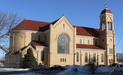
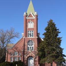
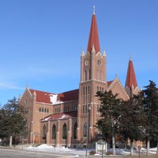
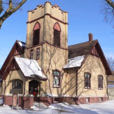
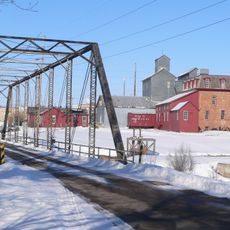
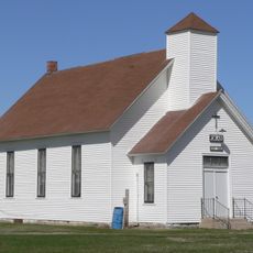
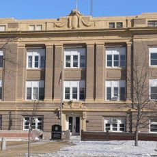
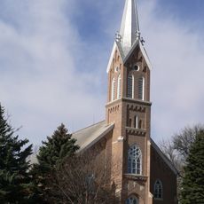
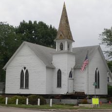
St. Anthony's Church and School, Romanesque Revival church and school in Boone County, Nebraska.

St. Anthony's Church and School is a Romanesque Revival structure with stone walls, rounded arch windows, and two prominent towers defining its exterior. The school building adjoins the church, creating a unified complex that demonstrates the period's architectural character.

Architect Jacob M. Nachtigall designed this structure, which opened in 1911 to serve as a religious and educational center for the community. Its construction reflects the early 1900s period when immigrant Catholic communities established their own institutions.

The church served for generations as a gathering place and school for a German Catholic community seeking to preserve their faith and traditions. Visitors can observe how the building still functions as both a spiritual home and community anchor today.

The site is accessible and well-maintained, allowing visitors to examine the architectural details throughout. Checking when services occur beforehand helps you experience how the building remains active in the community today.

The structure earned recognition on the National Register of Historic Places for its importance to early American ecclesiastical architecture. This designation acknowledges its value as a testament to how immigrant communities shaped architectural styles across the country.

Location: Boone County

Inception: 1911

Architects: Jacob M. Nachtigall

Architectural style: Romanesque Revival architecture

GPS coordinates: 41.56056,-98.15083

Latest update: December 14, 2025 18:46

Photos
Around this place
Lone Tree Monument
United States of America

Lone Tree Monument

55.2 km
Neligh Mill
United States of America

Neligh Mill

63.8 km
Olson Nature Preserve
United States of America

Olson Nature Preserve

26.9 km
Church of the Visitation of the Blessed Virgin Mary
United States of America

Church of the Visitation of the Blessed Virgin Mary

27.6 km
A.T. Ranch Headquarters
United States of America

A.T. Ranch Headquarters

51.9 km
Riverside Park Dance Pavilion
United States of America

Riverside Park Dance Pavilion

53.8 km
St. Michael's Catholic Church Complex
United States of America

St. Michael's Catholic Church Complex

22.8 km
Heber Hord House
United States of America

Heber Hord House

51.3 km
Moses Merrill Baptist Camp
United States of America

Moses Merrill Baptist Camp

25.2 km
Merrick County Courthouse
United States of America

Merrick County Courthouse

51.3 km
State Theatre
United States of America

State Theatre

51.1 km
Wright Morris Boyhood House
United States of America

Wright Morris Boyhood House

50.4 km
St. Peder's Dansk Evangelical Lutheran Kirke
United States of America

St. Peder's Dansk Evangelical Lutheran Kirke

61.2 km
Dannevirke Danish Lutheran Church and Community Hall
United States of America

Dannevirke Danish Lutheran Church and Community Hall

53.6 km
First Presbyterian Church
United States of America

First Presbyterian Church

22.3 km
Neligh Mill Bridge
United States of America

Neligh Mill Bridge

63.7 km
Howard County Courthouse
United States of America

Howard County Courthouse

46.2 km
North Loup Bridge
United States of America

North Loup Bridge

50.4 km
Columbia Hall
United States of America

Columbia Hall

59.3 km
Monroe Congregational Church and New Hope Cemetery
United States of America

Monroe Congregational Church and New Hope Cemetery

41.6 km
Greeley County Courthouse
United States of America

Greeley County Courthouse

31.6 km
Former Wheeler County Courthouse
United States of America

Former Wheeler County Courthouse

49.1 km
St. Michael's Catholic Church
United States of America

St. Michael's Catholic Church

54.2 km
Warrick House
United States of America

Warrick House

62.1 km
Evangelical United Brethren Church
United States of America

Evangelical United Brethren Church

26.9 km
Humphrey City Hall
United States of America

Humphrey City Hall

57.2 km
Maybury–McPherson House
United States of America

Maybury–McPherson House

64.1 km
New Moon Theater
United States of America

New Moon Theater

63.9 km
Show the full map
Reviews

Visited this place? Tap the stars to rate it and share your experience / photos with the community! Try now! You can cancel it anytime.

« St. Anthony's Church and School - Romanesque Revival church and school in Boone County, Nebraska » is provided by Around Us (aroundus.com). Images and texts are derived from Wikimedia project under a Creative Commons license. You are allowed to copy, distribute, and modify copies of this page, under the conditions set by the license, as long as this note is clearly visible.

Discover hidden gems everywhere you go!

From secret cafés to breathtaking viewpoints, skip the crowded tourist spots and find places that match your style. Our app makes it easy with voice search, smart filtering, route optimization, and insider tips from travelers worldwide. Download now for the complete mobile experience.

Around Us App Screenshot

A unique approach to discovering new places

Le Figaro

All the places worth exploring

France Info

A tailor-made excursion in just a few clicks

20 Minutes