Enable Location

We need your location to show you interesting places around you

Discover nearby places

Find interesting locations and hidden gems around you

Precise directions

Get accurate directions and distances to places

Your location is never shared with other users. It's only used when you tap the location button.

Fremont County Courthouse

Log in to your account

Start exploring — it's free

Trusted by 62,495 travelers worldwide

Continue with Google
Continue with Apple
or

We will send you a code to connect

By continuing, you accept our Terms and Conditions and our Privacy Policy

Check your inbox

We've sent a pincode in your inbox. Please enter the code below.

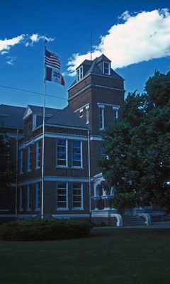
Fremont County Courthouse, courthouse in Iowa, United States

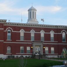
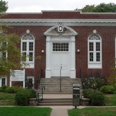
The Fremont County Courthouse is a county courthouse in Sidney, Iowa, built in 1889 from brick with stone accents and featuring two stories topped by a square tower. The structure displays rounded arch entries supported by short stone columns, dormer windows with triangular pediments, and oculus windows characteristic of late 19th-century courthouse design.

This courthouse was built after the original 1860 structure was destroyed by a gunpowder explosion in 1888, an event that prompted immediate reconstruction. The county seat was established in Sidney in 1851 after moving from Austin, making the town the administrative center for the newly organized county.

The courthouse served as a gathering place for residents seeking justice and attending community meetings over many decades. Its straightforward architecture reflects the practical values of Sidney's early settlers, who prioritized durability and function over decoration.

The courthouse sits on a full city block in central Sidney, making it easily accessible for visitors interested in exploring its architecture and history. The entrance steps show wear from decades of use, providing a tangible sense of the building's age and continuous occupation.

The original 1860 courthouse was destroyed by thieves who used stolen gunpowder to trigger an explosion that damaged windows, doors, and portions of the roof and upper floor. This unusual act of destruction directly led to construction of the current building and remains a striking example of how crime shaped local development.

The community of curious travelers

AroundUs brings together thousands of curated places, local tips, and hidden gems, enriched daily by 60,000 contributors worldwide.

Start exploring
Location
GPS coordinates
40.74583,-95.64361
Latest update
February 9, 2026 07:43
Around this place
Arbor Lodge State Historical Park and Arboretum
United States of America

Arbor Lodge State Historical Park and Arboretum

21.4 km
Mayhew Cabin
United States of America

Mayhew Cabin

20.7 km
Waubonsie State Park
United States of America

Waubonsie State Park

9 km
McKissick Island
United States of America

McKissick Island

22.7 km
Plattsmouth Bridge
United States of America

Plattsmouth Bridge

34 km
Otoe County Courthouse
United States of America

Otoe County Courthouse

19.7 km
St. Patrick Church
United States of America

St. Patrick Church

23.7 km
Todd House
United States of America

Todd House

17.3 km
Grand Army of the Republic Memorial Hall
United States of America

Grand Army of the Republic Memorial Hall

19.6 km
Morton-James Public Library
United States of America

Morton-James Public Library

19.7 km
Tabor Congregational Church
United States of America

Tabor Congregational Church

17.4 km
Harmony School, School District No. 53
United States of America

Harmony School, School District No. 53

28.9 km
Boscobel
United States of America

Boscobel

20.9 km
Women's Christian Temperance Union Public Fountain
United States of America

Women's Christian Temperance Union Public Fountain

23 km
George F. Lee Octagon Houses
United States of America

George F. Lee Octagon Houses

23.6 km
St. Benedict's Catholic Church
United States of America

St. Benedict's Catholic Church

18.7 km
Hamburg Public Library
United States of America

Hamburg Public Library

15.6 km
Chautauqua Pavilion
United States of America

Chautauqua Pavilion

9.5 km
Nehawka Public Library
United States of America

Nehawka Public Library

30.5 km
United States of America

Young Cemetery Cabin

30.9 km
Jason and Elizabeth Baylor Rector House
United States of America

Jason and Elizabeth Baylor Rector House

5.8 km
Jasper A. Ware House
United States of America

Jasper A. Ware House

21.6 km
Distrito electoral de Liberty
United States of America

Distrito electoral de Liberty

23.3 km
Naomi Institute
United States of America

Naomi Institute

27 km
Nebraska City Bridge
United States of America

Nebraska City Bridge

17.8 km
Arbor Day Farm
United States of America

Arbor Day Farm

21.6 km
Nebraska City Bridge
United States of America

Nebraska City Bridge

17.8 km
Hunter School
United States of America

Hunter School

14.4 km
Show the full map
« Fremont County Courthouse - courthouse in Iowa, United States » is provided by Around Us (aroundus.com). Images and texts are derived from Wikimedia project under a Creative Commons license. You are allowed to copy, distribute, and modify copies of this page, under the conditions set by the license, as long as this note is clearly visible.

Discover hidden gems everywhere you go!

From secret cafés to breathtaking viewpoints, skip the crowded tourist spots and find places that match your style. Our app makes it easy with voice search, smart filtering, route optimization, and insider tips from travelers worldwide. Download now for the complete mobile experience.

Around Us App Screenshot

A unique approach to discovering new places

Le Figaro

All the places worth exploring

France Info

A tailor-made excursion in just a few clicks

20 Minutes

Around Us
Travel Guide & Maps
Download

Send to your phone

QR Code
1

Open the camera app on your mobile.

2

Point at the QR code with your camera. A notification will appear.

3

Tap the notification to open the link.