Enable Location

We need your location to show you interesting places around you

Discover nearby places

Find interesting locations and hidden gems around you

Precise directions

Get accurate directions and distances to places

Your location is never shared with other users. It's only used when you tap the location button.

McKissick Island

Log in to your account

Start exploring — it's free

Trusted by 65,875 travelers worldwide

Continue with Google
Continue with Apple
or

We will send you a code to connect

By continuing, you accept our Terms and Conditions and our Privacy Policy

Check your inbox

We've sent a pincode in your inbox. Please enter the code below.

McKissick Island
Discussion Reviews 1 Photos
3.2k Popularity

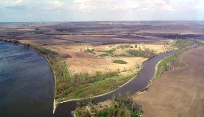
McKissick Island, River island in Missouri, United States

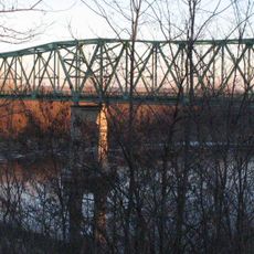
McKissick Island is a river island in Missouri, sitting in the Missouri River and used mainly for farming. The land is flat and open, with few structures visible across its surface.

The McKissick family settled the land in the 1840s, before the state borders in the region had been formally drawn. A Supreme Court ruling in 1904 determined that the island belonged to Nebraska rather than Missouri, fixing its legal status for good.

The island sits next to Missouri but is legally part of Nebraska, a fact that shapes how it is administered and perceived by people on both sides of the river. Visitors who know this tend to look at the flat, open farmland with fresh eyes, aware that the ground beneath them belongs to a different state than the one they can see across the water.

Reaching the island takes some planning, as it sits in the river and has no standard tourist facilities on site. It is worth checking access conditions in advance, since the island falls under Nebraska jurisdiction even though it is reached from the Missouri side of the river.

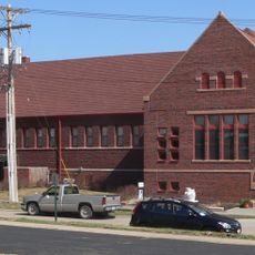
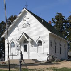
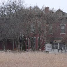
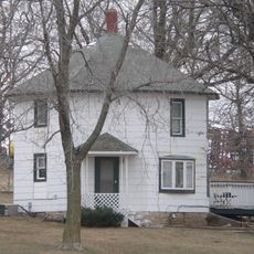
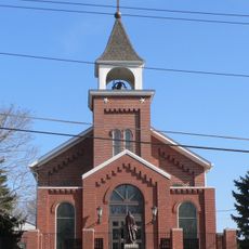
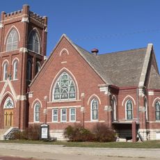
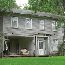
A serious flood wiped out most of the buildings that once stood here, erasing nearly all physical traces of what had been a small farming community. A church and a school had once served the people who lived on the island, but almost nothing of that era remains visible today.

The community of curious travelers

AroundUs brings together thousands of curated places, local tips, and hidden gems, enriched daily by 60,000 contributors worldwide.

Start exploring
Location
GPS coordinates
40.54340,-95.67360
Latest update
March 3, 2026 13:55
Around this place
Arbor Lodge State Historical Park and Arboretum
United States of America

Arbor Lodge State Historical Park and Arboretum

23.3 km
Mayhew Cabin
United States of America

Mayhew Cabin

22 km
Waubonsie State Park
United States of America

Waubonsie State Park

14.4 km
Captain Meriwether Lewis
United States of America

Captain Meriwether Lewis

16.7 km
Brownville Bridge
United States of America

Brownville Bridge

16.2 km
Otoe County Courthouse
United States of America

Otoe County Courthouse

21.5 km
Fremont County Courthouse
United States of America

Fremont County Courthouse

22.7 km
Atchison County Memorial Building
United States of America

Atchison County Memorial Building

20 km
Grand Army of the Republic Memorial Hall
United States of America

Grand Army of the Republic Memorial Hall

21.4 km
Morton-James Public Library
United States of America

Morton-James Public Library

21.4 km
Harmony School, School District No. 53
United States of America

Harmony School, School District No. 53

16.8 km
Rankin Hall
United States of America

Rankin Hall

26.2 km
Boscobel
United States of America

Boscobel

23.2 km
George F. Lee Octagon Houses
United States of America

George F. Lee Octagon Houses

11.4 km
St. Benedict's Catholic Church
United States of America

St. Benedict's Catholic Church

20 km
First United Presbyterian Church
United States of America

First United Presbyterian Church

22.7 km
John W. Bennett House
United States of America

John W. Bennett House

16.9 km
Hamburg Public Library
United States of America

Hamburg Public Library

7.1 km
Chautauqua Pavilion
United States of America

Chautauqua Pavilion

17.8 km
John Dickinson Dopf Mansion
United States of America

John Dickinson Dopf Mansion

19.7 km
Wilber T. Reed House
United States of America

Wilber T. Reed House

22.2 km
Jason and Elizabeth Baylor Rector House
United States of America

Jason and Elizabeth Baylor Rector House

21.3 km
Nemaha County Courthouse
United States of America

Nemaha County Courthouse

22.8 km
Jasper A. Ware House
United States of America

Jasper A. Ware House

22.6 km
River Inn Resort
United States of America

River Inn Resort

16.9 km
Nebraska City Bridge
United States of America

Nebraska City Bridge

19.4 km
Arbor Day Farm
United States of America

Arbor Day Farm

23.4 km
Nebraska City Bridge
United States of America

Nebraska City Bridge

19.4 km
Show the full map
Reviews
Share your experience

No review yet

Discussions
Start a discussion...

No discussion yet

« McKissick Island - River island in Missouri, United States » is provided by Around Us (aroundus.com). Images and texts are derived from Wikimedia project under a Creative Commons license. You are allowed to copy, distribute, and modify copies of this page, under the conditions set by the license, as long as this note is clearly visible.

Discover hidden gems everywhere you go!

From secret cafés to breathtaking viewpoints, skip the crowded tourist spots and find places that match your style. Our app makes it easy with voice search, smart filtering, route optimization, and insider tips from travelers worldwide. Download now for the complete mobile experience.

Around Us App Screenshot

A unique approach to discovering new places

Le Figaro

All the places worth exploring

France Info

A tailor-made excursion in just a few clicks

20 Minutes

Around Us
Travel Guide & Maps
Download

Send to your phone

QR Code
1

Open the camera app on your mobile.

2

Point at the QR code with your camera. A notification will appear.

3

Tap the notification to open the link.