Enable Location

We need your location to show you interesting places around you

Discover nearby places

Find interesting locations and hidden gems around you

Precise directions

Get accurate directions and distances to places

Your location is never shared with other users. It's only used when you tap the location button.

Brownville Bridge

Log in to your account

Start exploring — it's free

Trusted by 61,514 travelers worldwide

Continue with Google
Continue with Apple
or

We will send you a code to connect

By continuing, you accept our Terms and Conditions and our Privacy Policy

Check your inbox

We've sent a pincode in your inbox. Please enter the code below.

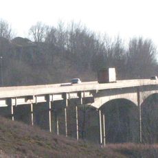
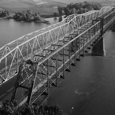
Brownville Bridge, Truss road bridge between Missouri and Nebraska, United States

Description

The Brownville Bridge is a road crossing that spans the Missouri River between Missouri and Nebraska. The structure features a Warren truss design with two traffic lanes and carries vehicles between the two states.

History

The crossing was built in 1939 and initially operated as a toll route before becoming free to use. It has been maintained by the state transportation department since the transition to public access.

Culture

The bridge serves as a vital crossing that connects neighboring communities on opposite banks of the river. For residents in the region, it represents a practical link that has shaped local travel patterns and commerce for generations.

Practical

The narrow lanes require careful driving, especially when vehicles meet in the middle of the crossing. Travelers should be aware this is a functional crossing without rest stops or viewing areas.

Did you know?

The structure underwent extensive renovation in the early 2000s with a complete replacement of the deck surface. These modernization efforts preserved the historic crossing in working condition for decades to come.

Location
Location
GPS coordinates
40.39917,-95.65167
Latest update
December 14, 2025 09:43

AroundUs brings together thousands of curated places, local tips, and hidden gems, enriched daily by 60,000 contributors worldwide. Discover all places nearby (Missouri).

Around this place
Indian Cave State Park
United States of America

Indian Cave State Park

18.3 km
Mayhew Cabin
United States of America

Mayhew Cabin

35.7 km
Waubonsie State Park
United States of America

Waubonsie State Park

30.6 km
McKissick Island
United States of America

McKissick Island

16.2 km
Captain Meriwether Lewis
United States of America

Captain Meriwether Lewis

504 m
Otoe County Courthouse
United States of America

Otoe County Courthouse

35.4 km
St. John's Evangelical Lutheran Church
United States of America

St. John's Evangelical Lutheran Church

23.8 km
Atchison County Memorial Building
United States of America

Atchison County Memorial Building

11.7 km
Grand Army of the Republic Memorial Hall
United States of America

Grand Army of the Republic Memorial Hall

35.4 km
St. John's Lutheran Church Complex
United States of America

St. John's Lutheran Church Complex

26.9 km
Morton-James Public Library
United States of America

Morton-James Public Library

35.3 km
Harmony School, School District No. 53
United States of America

Harmony School, School District No. 53

25.3 km
Rankin Hall
United States of America

Rankin Hall

22.6 km
Itha T. Krumme Memorial Arboretum
United States of America

Itha T. Krumme Memorial Arboretum

36.9 km
John Holman House
United States of America

John Holman House

35.7 km
George F. Lee Octagon Houses
United States of America

George F. Lee Octagon Houses

23.1 km
St. Benedict's Catholic Church
United States of America

St. Benedict's Catholic Church

34.1 km
First United Presbyterian Church
United States of America

First United Presbyterian Church

16.3 km
John W. Bennett House
United States of America

John W. Bennett House

2.1 km
Hamburg Public Library
United States of America

Hamburg Public Library

23.1 km
Chautauqua Pavilion
United States of America

Chautauqua Pavilion

32.2 km
John Dickinson Dopf Mansion
United States of America

John Dickinson Dopf Mansion

11.4 km
Wilber T. Reed House
United States of America

Wilber T. Reed House

16.4 km
Nemaha County Courthouse
United States of America

Nemaha County Courthouse

16.4 km
Jasper A. Ware House
United States of America

Jasper A. Ware House

36 km
River Inn Resort
United States of America

River Inn Resort

799 m
Nebraska City Bridge
United States of America

Nebraska City Bridge

33.8 km
Nebraska City Bridge
United States of America

Nebraska City Bridge

33.8 km
Show the full map
« Brownville Bridge - Truss road bridge between Missouri and Nebraska, United States » is provided by Around Us (aroundus.com). Images and texts are derived from Wikimedia project under a Creative Commons license. You are allowed to copy, distribute, and modify copies of this page, under the conditions set by the license, as long as this note is clearly visible.

Discover hidden gems everywhere you go!

From secret cafés to breathtaking viewpoints, skip the crowded tourist spots and find places that match your style. Our app makes it easy with voice search, smart filtering, route optimization, and insider tips from travelers worldwide. Download now for the complete mobile experience.

Around Us App Screenshot

A unique approach to discovering new places

Le Figaro

All the places worth exploring

France Info

A tailor-made excursion in just a few clicks

20 Minutes

Around Us
Travel Guide & Maps
Download

Send to your phone

QR Code
1

Open the camera app on your mobile.

2

Point at the QR code with your camera. A notification will appear.

3

Tap the notification to open the link.