Enable Location

We need your location to show you interesting places around you

Discover nearby places

Find interesting locations and hidden gems around you

Precise directions

Get accurate directions and distances to places

Your location is never shared with other users. It's only used when you tap the location button.

Meades Ranch Triangulation Station

Log in to your account

Start exploring — it's free

Trusted by 63,412 travelers worldwide

Continue with Google
Continue with Apple
or

We will send you a code to connect

By continuing, you accept our Terms and Conditions and our Privacy Policy

Check your inbox

We've sent a pincode in your inbox. Please enter the code below.

Discussion Reviews 2 Photos
7.3k Popularity

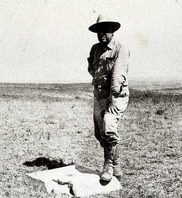
Meades Ranch Triangulation Station, Survey marker in Osborne County, Kansas, United States.

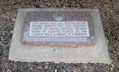
Meades Ranch Triangulation Station is a surveying landmark in Osborne County, Kansas that uses a bronze disk embedded in concrete to mark a specific geographic location. A tall concrete dome protects the marker at ground level to ensure the point remains visible and accessible to surveyors and researchers who need to reference this exact spot.

The station was established in 1891 along the 39th Parallel as part of a continental survey network. It became the primary reference point for North American mapping and remained central to surveying work across the continent until mapping methods changed in the mid-20th century.

The station earned recognition on the National Register of Historic Places in 1973 as the Geodetic Center of the United States.

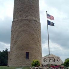
A replica of the marker and informational display are located at a rest area along U.S. Highway 281 at the north edge of Osborne. This accessible location makes it easy for travelers to stop and learn about the surveying point without leaving the main highway.

The coordinates of this point and its bearing to a neighboring station formed the foundation for the North American Datum of 1927. This standard was used to create maps and conduct surveys across the continent for decades until newer satellite-based methods took over.

The community of curious travelers

AroundUs brings together thousands of curated places, local tips, and hidden gems, enriched daily by 60,000 contributors worldwide.

Start exploring
Location
Inception
1913
Address
County Road 691
GPS coordinates
39.22417,-98.54194
Latest update
December 8, 2025 20:03
Around this place
Wilson Lake
United States of America

Wilson Lake

31.6 km
United States of America

Waconda Lake

33.1 km
Wilson State Park
United States of America

Wilson State Park

34.4 km
Dream Theater
United States of America

Dream Theater

46.1 km
St. John the Baptist Catholic Church
United States of America

St. John the Baptist Catholic Church

46 km
Pott's Ford Bridge
United States of America

Pott's Ford Bridge

60.9 km
Bridge 650
United States of America

Bridge 650

61.4 km
Paradise Water Tower
United States of America

Paradise Water Tower

34.3 km
Natoma Presbyterian Church
United States of America

Natoma Presbyterian Church

41.5 km
Mitchell County Courthouse
United States of America

Mitchell County Courthouse

45.5 km
Glasco Downtown Historic District
United States of America

Glasco Downtown Historic District

62.4 km
Danske Evangelist Lutheran Kirke
United States of America

Danske Evangelist Lutheran Kirke

27.3 km
First National Bank Building
United States of America

First National Bank Building

65.1 km
Downs Carnegie Library
United States of America

Downs Carnegie Library

30.7 km
Old Cawker City Library
United States of America

Old Cawker City Library

33.3 km
Arthur Larkin House
United States of America

Arthur Larkin House

61.8 km
Ellsworth Downtown Historic District
United States of America

Ellsworth Downtown Historic District

61.3 km
Lincoln County Courthouse
United States of America

Lincoln County Courthouse

39.9 km
Pottawatomie County Fair Pavilion
United States of America

Pottawatomie County Fair Pavilion

63.7 km
Osborne Public Carnegie Library
United States of America

Osborne Public Carnegie Library

27.4 km
Perry Hodgden House
United States of America

Perry Hodgden House

61.3 km
Cummins Block Building
United States of America

Cummins Block Building

39.8 km
Insurance Building
United States of America

Insurance Building

61.3 km
Samuel P. Dinsmoor's Garden of Eden
United States of America

Samuel P. Dinsmoor's Garden of Eden

18.5 km
Ft Harker Museum
United States of America

Ft Harker Museum

66 km
Spring Creek Tributary Bridge
United States of America

Spring Creek Tributary Bridge

43.6 km
Salt Creek Bridge
United States of America

Salt Creek Bridge

42.5 km
Bullfoot Creek Bridge
United States of America

Bullfoot Creek Bridge

36.9 km
Show the full map
Reviews
Share your experience

No review yet

Discussions
Start a discussion...

No discussion yet

« Meades Ranch Triangulation Station - Survey marker in Osborne County, Kansas, United States » is provided by Around Us (aroundus.com). Images and texts are derived from Wikimedia project under a Creative Commons license. You are allowed to copy, distribute, and modify copies of this page, under the conditions set by the license, as long as this note is clearly visible.

Discover hidden gems everywhere you go!

From secret cafés to breathtaking viewpoints, skip the crowded tourist spots and find places that match your style. Our app makes it easy with voice search, smart filtering, route optimization, and insider tips from travelers worldwide. Download now for the complete mobile experience.

Around Us App Screenshot

A unique approach to discovering new places

Le Figaro

All the places worth exploring

France Info

A tailor-made excursion in just a few clicks

20 Minutes

Around Us
Travel Guide & Maps
Download

Send to your phone

QR Code
1

Open the camera app on your mobile.

2

Point at the QR code with your camera. A notification will appear.

3

Tap the notification to open the link.