Log in to your account

AroundUs is a community-driven map of interesting places, built by curious explorers like you. It grows with every review, story, and photo you share.
Connect to save your favorite spots, contribute locations, and create personalized routes.
Continue with Google
Continue with Apple
Continue with X
Continue with Facebook
Continue with email
By continuing, you accept our Terms and Conditions and our Privacy Policy
Create an account

George Washington State Forest

Add to collection
Map
Suggest a change
Share

George Washington State Forest, State forest in Itasca and Koochiching Counties, United States.

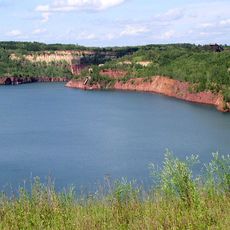
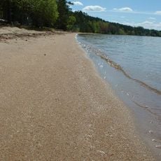
George Washington State Forest spreads across roughly 320,000 acres and blends forests, wetlands, lakes, and numerous smaller water bodies with an extensive shoreline. The landscape offers varied habitats that visitors can explore through hiking and water-based activities.

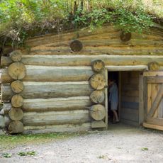
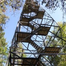
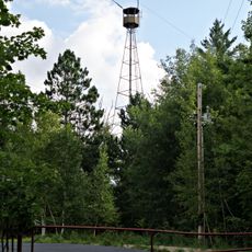
The forest was founded in 1931 to honor George Washington's 200th birthday and create a lasting tribute to this historic occasion. Several Civilian Conservation Corps camps operated here during the 1930s and 1940s, building infrastructure and improving the land.

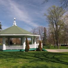
Local residents use the forest for hunting, fishing, and recreation, which shapes daily life in this heavily forested region. The woods and lakes are central to how people here connect with their surroundings and spend their free time.

Eight campgrounds are spread throughout the forest, offering lodging options along with specialized areas for horseback riders and backcountry campers. Visitors should check conditions before arriving, as activities and trail access vary by season and weather.

The forest features over 320 kilometers of trails that shift between winter and summer activities, with dedicated routes for cross-country skiing, snowmobiling, horseback riding, and mountain biking. This seasonal variety means the experience changes dramatically depending on when you visit.

Location: Itasca County

Location: Koochiching County

Location: St. Louis County

Inception: 1931

Website: http://dnr.state.mn.us/state_forests/sft00021

GPS coordinates: 47.41190,-93.11460

Latest update: December 14, 2025 11:23

Photos
Around this place
Greyhound Bus Museum
United States of America

Greyhound Bus Museum

13.5 km
Hill Annex Mine State Park
United States of America

Hill Annex Mine State Park

14.3 km
McCarthy Beach State Park
United States of America

McCarthy Beach State Park

29.7 km
Forest History Center
United States of America

Forest History Center

39.6 km
Church of the Holy Family
United States of America

Church of the Holy Family

43.8 km
Olcott Park
United States of America

Olcott Park

44.4 km
Hibbing City Hall
United States of America

Hibbing City Hall

13.5 km
Buhl City Hall
United States of America

Buhl City Hall

27 km
Bruce Mine Headframe
United States of America

Bruce Mine Headframe

20.1 km
Andrew G. Anderson House
United States of America

Andrew G. Anderson House

14.1 km
Church of St. Joseph
United States of America

Church of St. Joseph

44.6 km
Saints Peter and Paul Church-Ukrainian Catholic
United States of America

Saints Peter and Paul Church-Ukrainian Catholic

19.5 km
Sons of Italy Hall
United States of America

Sons of Italy Hall

13.7 km
Eveleth Manual Training School
United States of America

Eveleth Manual Training School

44.2 km
East Howard Street Commercial Historic District
United States of America

East Howard Street Commercial Historic District

13.3 km
Coleraine Methodist Episcopal Church
United States of America

Coleraine Methodist Episcopal Church

27.4 km
Church of the Good Shepherd
United States of America

Church of the Good Shepherd

27.5 km
Mitchell–Tappan House
United States of America

Mitchell–Tappan House

13.4 km
Delvic Building
United States of America

Delvic Building

13.1 km
Chisholm Commercial Historic District
United States of America

Chisholm Commercial Historic District

19.5 km
Emmett Butler House
United States of America

Emmett Butler House

12.9 km
W. Bailey House
United States of America

W. Bailey House

44 km
United States of America

Buhl Public Library

27.1 km
Thunder Alley XL
United States of America

Thunder Alley XL

35.2 km
Minnesota Discovery Center
United States of America

Minnesota Discovery Center

18 km
Olcott Park Electric Fountain and Rock Garden
United States of America

Olcott Park Electric Fountain and Rock Garden

44.4 km
Side Lake Lookout Tower
United States of America

Side Lake Lookout Tower

30.5 km
Coleraine Fire Lookout Tower
United States of America

Coleraine Fire Lookout Tower

29.2 km
Show the full map
Reviews

Visited this place? Tap the stars to rate it and share your experience / photos with the community! Try now! You can cancel it anytime.

« George Washington State Forest - State forest in Itasca and Koochiching Counties, United States » is provided by Around Us (aroundus.com). Images and texts are derived from Wikimedia project under a Creative Commons license. You are allowed to copy, distribute, and modify copies of this page, under the conditions set by the license, as long as this note is clearly visible.

Discover hidden gems everywhere you go!

From secret cafés to breathtaking viewpoints, skip the crowded tourist spots and find places that match your style. Our app makes it easy with voice search, smart filtering, route optimization, and insider tips from travelers worldwide. Download now for the complete mobile experience.

Around Us App Screenshot

A unique approach to discovering new places

Le Figaro

All the places worth exploring

France Info

A tailor-made excursion in just a few clicks

20 Minutes