Enable Location

We need your location to show you interesting places around you

Discover nearby places

Find interesting locations and hidden gems around you

Precise directions

Get accurate directions and distances to places

Your location is never shared with other users. It's only used when you tap the location button.

Henderson Hall Historic District

Log in to your account

Start exploring — it's free

Trusted by 61,429 travelers worldwide

Continue with Google
Continue with Apple
or

We will send you a code to connect

By continuing, you accept our Terms and Conditions and our Privacy Policy

Check your inbox

We've sent a pincode in your inbox. Please enter the code below.

Henderson Hall Historic District, Historic district in Wood County, West Virginia, United States

Description

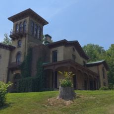
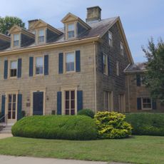
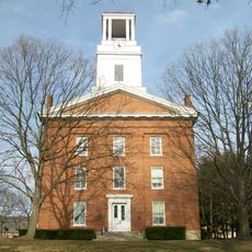
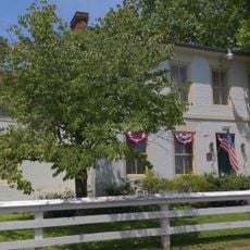
Henderson Hall Historic District is a building complex spanning about 65 acres in Wood County with ten structures from the 19th century, including an Italianate mansion, worker housing, barns, and various agricultural buildings. Scattered across the grounds are three prehistoric earthen mounds from the Adena culture and a family cemetery.

History

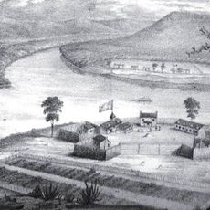
The Henderson family established their settlement during the early phase of European occupation in the region and turned the property into a major operation for its time. The place lost its economic importance after the Civil War and was never again operated at the same scale.

Culture

The Henderson family cemetery anchors the landscape and shows how deeply this community was rooted in the place across generations. The gravestones and their layout tell stories about the people who lived and died here.

Practical

The grounds are open to walk through on your own, allowing you to explore the different buildings and terrain at your own pace while experiencing the layout and character of the property. Good footwear is helpful since the ground can be uneven depending on the season.

Did you know?

The three earth mounds on the grounds date to a culture that lived here long before Europeans arrived, and their presence is often overlooked by visitors. These archaeological features offer a window into a much older history of the place.

Location
Location
GPS coordinates
39.37780,-81.48280
Latest update
December 12, 2025 14:22

AroundUs brings together thousands of curated places, local tips, and hidden gems, enriched daily by 60,000 contributors worldwide. Discover all places nearby (West Virginia).

Around this place
Fort Harmar
United States of America

Fort Harmar

4.2 km
The Anchorage
United States of America

The Anchorage

4.3 km
Start Westward Memorial
United States of America

Start Westward Memorial

4.7 km
Williamstown Bridge
United States of America

Williamstown Bridge

4.5 km
Harmar Historic District
United States of America

Harmar Historic District

4 km
Marietta Historic District
United States of America

Marietta Historic District

5.1 km
Washington County Courthouse
United States of America

Washington County Courthouse

5 km
Tomlinson Mansion
United States of America

Tomlinson Mansion

3 km
David Putnam House
United States of America

David Putnam House

4.4 km
Muskingum Island
United States of America

Muskingum Island

2 km
First Unitarian Church of Marietta
United States of America

First Unitarian Church of Marietta

5 km
Peoples Bank Theatre
United States of America

Peoples Bank Theatre

4.9 km
Ohio River Museum
United States of America

Ohio River Museum

5.1 km
Mid-Ohio Valley Players Theatre
United States of America

Mid-Ohio Valley Players Theatre

4.9 km
Children's Toy & Doll Museum
United States of America

Children's Toy & Doll Museum

4.1 km
Putnam Street Bridge
United States of America

Putnam Street Bridge

4.5 km
Erwin Hall
United States of America

Erwin Hall

5.2 km
Putnam Street Bridge
United States of America

Putnam Street Bridge

4.6 km
Peoples Mortuary Museum
United States of America

Peoples Mortuary Museum

5 km
The Henry Fearing House
United States of America

The Henry Fearing House

4 km
Harmar Bridge
United States of America

Harmar Bridge

4.4 km
Old Muskingum Lockhouse
United States of America

Old Muskingum Lockhouse

4.6 km
The Towboat W. P. Snyder Jr.
United States of America

The Towboat W. P. Snyder Jr.

5 km
Ohio National Guard Armory
United States of America

Ohio National Guard Armory

4.6 km
Shipbuilding, Commodore Abraham Whipple
United States of America

Shipbuilding, Commodore Abraham Whipple

4.5 km
Muskingum River Underground Railroad
United States of America

Muskingum River Underground Railroad

5 km
Lewis and Clark Expedition
United States of America

Lewis and Clark Expedition

4.2 km
The Towboat of W.P. Snyder Jr.
United States of America

The Towboat of W.P. Snyder Jr.

5 km
Show the full map
« Henderson Hall Historic District - Historic district in Wood County, West Virginia, United States » is provided by Around Us (aroundus.com). Images and texts are derived from Wikimedia project under a Creative Commons license. You are allowed to copy, distribute, and modify copies of this page, under the conditions set by the license, as long as this note is clearly visible.

Discover hidden gems everywhere you go!

From secret cafés to breathtaking viewpoints, skip the crowded tourist spots and find places that match your style. Our app makes it easy with voice search, smart filtering, route optimization, and insider tips from travelers worldwide. Download now for the complete mobile experience.

Around Us App Screenshot

A unique approach to discovering new places

Le Figaro

All the places worth exploring

France Info

A tailor-made excursion in just a few clicks

20 Minutes

Around Us
Travel Guide & Maps
Download

Send to your phone

QR Code
1

Open the camera app on your mobile.

2

Point at the QR code with your camera. A notification will appear.

3

Tap the notification to open the link.