Lakeport State Park, State park on Lake Huron in Burtchville Township, Michigan.
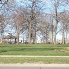
Lakeport State Park is a recreation area on the shoreline of Lake Huron, divided into two separate units with sandy beaches and wooded campground facilities. The two sections sit on opposite sides of Lakeport and together provide extensive lodging options and outdoor activities for visitors.
The site was founded in 1938 as Port Huron State Park and later received funding for improvements before being renamed and formally opened as Lakeport State Park in 1947. The transformation shows how the location grew into a major recreation destination for the region.
The South Unit holds historical importance as a former United Auto Workers retreat where the Port Huron Statement was completed and announced in 1962.
The site has two separate access points to the lake with different beach areas, each with its own amenities and facilities. Visitors should check in advance which of the two units best suits their needs, especially if they prefer beach activities.
Both northern and southern sections of the park provide separate beach access points to Lake Huron, allowing visitors to experience different shoreline perspectives.
Location: Michigan
Inception: 1946
Website: https://www2.dnr.state.mi.us/ParksandTrails/Details.aspx?id=466&type=SPRK
GPS coordinates: 43.12420,-82.49670
Latest update: December 10, 2025 16:29
Blue Water Bridge
15.2 km
St. Clair Tunnel
19.8 km
Forest
39.9 km
United States lightship Huron
16.1 km
Thomas Edison Depot Museum
15.1 km
Fort Gratiot
15.4 km
Fort Gratiot Light
14.4 km
St. Clair Inn
33 km
USCGC Bramble
19.2 km
Port Sanilac Light
34.1 km
Ladies of the Maccabees Building
16.7 km
Fort St. Joseph
14.7 km
Federal Building
17.6 km
Port Sanilac Masonic and Town Hall
34.4 km
James McColl House
24.5 km
Carnegie Center
17.9 km
Wilbur F. Davidson House
18.5 km
John L. Fead House
16.6 km
Wadhams Road–Pine River Bridge
28.6 km
Charles H. Moore – Albert E. Sleeper House
16.4 km
Loop-Harrison Mansion
33.6 km
Seventh Street–Black River Bridge
17.4 km
Masters Road–Belle River Bridge
34 km
Jeddo Road–South Branch Mill Creek Drain Bridge
27.7 km
Old Post Office
39.2 km
Victoria Hall
39.3 km
Petrolia Public Library
39.2 km
Military Street Bridge
17.6 kmVisited this place? Tap the stars to rate it and share your experience / photos with the community! Try now! You can cancel it anytime.
Discover hidden gems everywhere you go!
From secret cafés to breathtaking viewpoints, skip the crowded tourist spots and find places that match your style. Our app makes it easy with voice search, smart filtering, route optimization, and insider tips from travelers worldwide. Download now for the complete mobile experience.
A unique approach to discovering new places❞
— Le Figaro
All the places worth exploring❞
— France Info
A tailor-made excursion in just a few clicks❞
— 20 Minutes