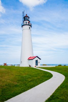
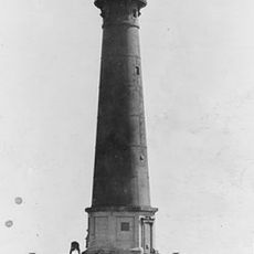
Fort Gratiot Light, Lighthouse on Lake Huron in Port Huron, Michigan
Fort Gratiot Light is a white lighthouse tower in Port Huron, Michigan, standing at the point where Lake Huron flows into the St. Clair River. The tower rises about 85 feet (26 meters) and is listed on the National Register of Historic Places as well as being a Michigan state historic site.
Congress authorized Michigan's first lighthouse at this location in 1825, shortly after the Erie Canal opened and brought more ships into the Great Lakes. The original structure was rebuilt and made taller in 1862 to keep up with the growing volume of traffic on the waterway.
The name Fort Gratiot comes from the old military fort that once stood on this land, and that history is still visible in the name of the surrounding neighborhood. Visitors walking the grounds today find the lighthouse embedded in a public park where locals come to watch ships pass through one of the busiest water corridors in the region.
The site is managed by St. Clair County Parks, and guided tours of the tower are available during the warmer months. Arriving on a clear day gives you the best views across the lake and river from the top of the structure.
This lighthouse was the first ever built in the state of Michigan, which makes it a starting point for the entire network of Great Lakes navigation aids that followed. Despite its age, it remains an active aid to navigation operated by the US Coast Guard.
The community of curious travelers
AroundUs brings together thousands of curated places, local tips, and hidden gems, enriched daily by 60,000 contributors worldwide.