Enable Location

We need your location to show you interesting places around you

Discover nearby places

Find interesting locations and hidden gems around you

Precise directions

Get accurate directions and distances to places

Your location is never shared with other users. It's only used when you tap the location button.

Layton Bridge

Log in to your account

Start exploring — it's free

Trusted by 61,361 travelers worldwide

Continue with Google
Continue with Apple
or

We will send you a code to connect

By continuing, you accept our Terms and Conditions and our Privacy Policy

Check your inbox

We've sent a pincode in your inbox. Please enter the code below.

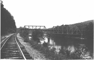
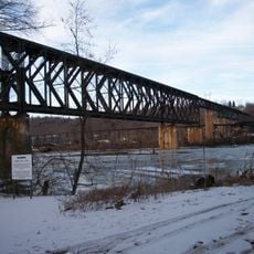
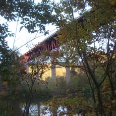
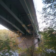
Layton Bridge, Railway bridge in Layton, Pennsylvania, US

Description

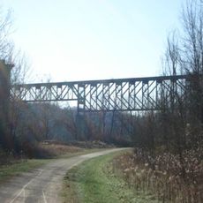
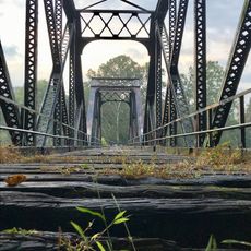
Layton Bridge is a railway crossing over the Youghiogheny River built with a steel Pratt truss design. The structure spans between Layton Road and connects two communities on opposite banks.

History

Construction began in 1893 by the A.P. Roberts Construction Company and was completed around 1899 for the Washington Run Railroad. After 1933, the bridge was converted to handle automobile traffic.

Culture

The bridge structure appears in multiple film productions, including the television series Justified and the film The Silence of the Lambs.

Practical

The bridge functions as a single-lane roadway that can be crossed on foot or by car. Visitors should note that the crossing is narrow with limited visibility in both directions.

Did you know?

Immediately at the western end of the bridge, a 208-foot-long tunnel begins right where the structure ends. This unusual pairing of bridge and tunnel creates a striking visual feature during the crossing.

Location
Official opening
1899
Longest Span
55 m
Width
4.35 m
Made from material
steel
GPS coordinates
40.08917,-79.73028
Latest update
December 14, 2025 11:03

AroundUs brings together thousands of curated places, local tips, and hidden gems, enriched daily by 60,000 contributors worldwide. Discover all places nearby (Layton).

Around this place
Youghiogheny River Trail
United States of America

Youghiogheny River Trail

8.4 km
Linden Hall at Saint James Park
United States of America

Linden Hall at Saint James Park

3.8 km
Providence Quaker Cemetery and Chapel
United States of America

Providence Quaker Cemetery and Chapel

4.8 km
Francis Farm Petroglyphs
United States of America

Francis Farm Petroglyphs

6.8 km
Belle Vernon Bridge
United States of America

Belle Vernon Bridge

13.3 km
St. Nicholas Byzantine Catholic Church
United States of America

St. Nicholas Byzantine Catholic Church

2 km
Speers Railroad Bridge
United States of America

Speers Railroad Bridge

13.4 km
Cochran Memorial United Methodist Church
United States of America

Cochran Memorial United Methodist Church

8 km
Alliance Furnace
United States of America

Alliance Furnace

2.8 km
Old Main
United States of America

Old Main

13.5 km
Star Junction Historic District
United States of America

Star Junction Historic District

4.1 km
Molly Fleming House
United States of America

Molly Fleming House

13 km
California Area Public Library
United States of America

California Area Public Library

13.7 km
Dick Building
United States of America

Dick Building

13.8 km
Dawson Historic District
United States of America

Dawson Historic District

7.7 km
Col. Edward Cook House
United States of America

Col. Edward Cook House

9.3 km
Laurel Hill Presbyterian Church
United States of America

Laurel Hill Presbyterian Church

12.8 km
Plumer House
United States of America

Plumer House

13.8 km
Searight's Fulling Mill
United States of America

Searight's Fulling Mill

1.4 km
Scottdale Historic District
United States of America

Scottdale Historic District

12.1 km
Matthew Smelser Memorial Bridge
United States of America

Matthew Smelser Memorial Bridge

8.5 km
Youghiogheny Bank of Pennsylvania
United States of America

Youghiogheny Bank of Pennsylvania

1.8 km
Banning Railroad Bridge
United States of America

Banning Railroad Bridge

4.2 km
Whitsett Historic District
United States of America

Whitsett Historic District

4.1 km
Smithton Low-Level Bridge
United States of America

Smithton Low-Level Bridge

7.6 km
Karolcik Building
United States of America

Karolcik Building

1.8 km
Arboreto de la universidad de California en Pensilvania
United States of America

Arboreto de la universidad de California en Pensilvania

13.4 km
Connellsville P&WV bridge
United States of America

Connellsville P&WV bridge

13.4 km
Show the full map
« Layton Bridge - Railway bridge in Layton, Pennsylvania, US » is provided by Around Us (aroundus.com). Images and texts are derived from Wikimedia project under a Creative Commons license. You are allowed to copy, distribute, and modify copies of this page, under the conditions set by the license, as long as this note is clearly visible.

Discover hidden gems everywhere you go!

From secret cafés to breathtaking viewpoints, skip the crowded tourist spots and find places that match your style. Our app makes it easy with voice search, smart filtering, route optimization, and insider tips from travelers worldwide. Download now for the complete mobile experience.

Around Us App Screenshot

A unique approach to discovering new places

Le Figaro

All the places worth exploring

France Info

A tailor-made excursion in just a few clicks

20 Minutes

Around Us
Travel Guide & Maps
Download

Send to your phone

QR Code
1

Open the camera app on your mobile.

2

Point at the QR code with your camera. A notification will appear.

3

Tap the notification to open the link.