Providence Quaker Cemetery and Chapel

Log in to your account

AroundUs is a community-driven map of interesting places, built by curious explorers like you. It grows with every review, story, and photo you share.
Connect to save your favorite spots, contribute locations, and create personalized routes.
Continue with Google
Continue with Apple
Continue with X
Continue with Facebook
Continue with email
By continuing, you accept our Terms and Conditions and our Privacy Policy
Create an account
Add to collection
Map
Suggest a change
Share

Providence Quaker Cemetery and Chapel, Religious site in Perryopolis, Pennsylvania, United States.

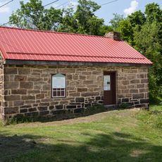
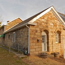
Providence Quaker Cemetery and Chapel is a small stone building erected in 1895 that sits among a burial ground containing graves from the late 1700s through the 1800s. The chapel features iron bars across its windows, dirt floors, and plastered stone walls creating a simple, austere interior space.

The stone chapel was built in 1895 from materials salvaged from an earlier Quaker meeting house that operated between 1793 and 1870. This repurposing of materials linked the site's spiritual continuity across generations of worshippers.

The burial ground reflects Quaker beliefs in humility, as many graves intentionally remain unmarked without stones to show equality among the deceased. This practice shaped the landscape, where only about 50 gravestones from the period between 1790 and 1870 still stand today.

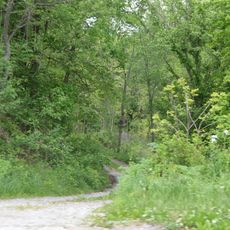
The site sits on Quaker Church Road about 2 miles southwest of Perryopolis and is easily reached by car along rural roads. Access is not permitted after sunset, so plan your visit during daylight hours to see the grounds properly.

The chapel remains locked but visitors can peer through the barred windows to glimpse the simple interior without disturbing the fragile structure inside. This arrangement allows the space to be viewed and appreciated from outside.

Location: Pennsylvania

Location: Fayette County

Location: Perryopolis

GPS coordinates: 40.07278,-79.78222

Latest update: December 14, 2025 09:42

Photos
Around this place
Bowman's Castle
United States of America

Bowman's Castle

10.3 km
Youghiogheny River Trail
United States of America

Youghiogheny River Trail

10 km
Linden Hall at Saint James Park
United States of America

Linden Hall at Saint James Park

7.4 km
Layton Bridge
United States of America

Layton Bridge

4.8 km
Lane Bane Bridge
United States of America

Lane Bane Bridge

10.3 km
Francis Farm Petroglyphs
United States of America

Francis Farm Petroglyphs

2.7 km
Belle Vernon Bridge
United States of America

Belle Vernon Bridge

10.1 km
St. Nicholas Byzantine Catholic Church
United States of America

St. Nicholas Byzantine Catholic Church

2.8 km
Speers Railroad Bridge
United States of America

Speers Railroad Bridge

10.3 km
Alliance Furnace
United States of America

Alliance Furnace

7.1 km
Old Main
United States of America

Old Main

8.8 km
Star Junction Historic District
United States of America

Star Junction Historic District

2.1 km
Brownsville Northside Historic District
United States of America

Brownsville Northside Historic District

10.1 km
Molly Fleming House
United States of America

Molly Fleming House

8.3 km
California Area Public Library
United States of America

California Area Public Library

9.1 km
Col. Edward Cook House
United States of America

Col. Edward Cook House

7.1 km
Jennings-Gallagher House
United States of America

Jennings-Gallagher House

9.3 km
West Brownsville Junction Bridge
United States of America

West Brownsville Junction Bridge

9.1 km
Searight's Fulling Mill
United States of America

Searight's Fulling Mill

3.4 km
Hugh Laughlin House
United States of America

Hugh Laughlin House

9.7 km
Matthew Smelser Memorial Bridge
United States of America

Matthew Smelser Memorial Bridge

10.1 km
Youghiogheny Bank of Pennsylvania
United States of America

Youghiogheny Bank of Pennsylvania

3.1 km
Whitsett Historic District
United States of America

Whitsett Historic District

3.8 km
Banning Railroad Bridge
United States of America

Banning Railroad Bridge

6.4 km
Smithton Low-Level Bridge
United States of America

Smithton Low-Level Bridge

9.9 km
Karolcik Building
United States of America

Karolcik Building

3 km
Arboreto de la universidad de California en Pensilvania
United States of America

Arboreto de la universidad de California en Pensilvania

8.8 km
Hepner–Bailey Field at Adamson Stadium
United States of America

Hepner–Bailey Field at Adamson Stadium

10.3 km
Show the full map
Reviews

Visited this place? Tap the stars to rate it and share your experience / photos with the community! Try now! You can cancel it anytime.

« Providence Quaker Cemetery and Chapel - Religious site in Perryopolis, Pennsylvania, United States » is provided by Around Us (aroundus.com). Images and texts are derived from Wikimedia project under a Creative Commons license. You are allowed to copy, distribute, and modify copies of this page, under the conditions set by the license, as long as this note is clearly visible.

Discover hidden gems everywhere you go!

From secret cafés to breathtaking viewpoints, skip the crowded tourist spots and find places that match your style. Our app makes it easy with voice search, smart filtering, route optimization, and insider tips from travelers worldwide. Download now for the complete mobile experience.

Around Us App Screenshot

A unique approach to discovering new places

Le Figaro

All the places worth exploring

France Info

A tailor-made excursion in just a few clicks

20 Minutes