Enable Location

We need your location to show you interesting places around you

Discover nearby places

Find interesting locations and hidden gems around you

Precise directions

Get accurate directions and distances to places

Your location is never shared with other users. It's only used when you tap the location button.

Linden Grove Cemetery

Log in to your account

Start exploring — it's free

Trusted by 62,491 travelers worldwide

Continue with Google
Continue with Apple
or

We will send you a code to connect

By continuing, you accept our Terms and Conditions and our Privacy Policy

Check your inbox

We've sent a pincode in your inbox. Please enter the code below.

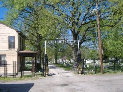
Linden Grove Cemetery, United States historic place in Kentucky

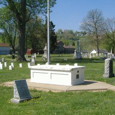
Linden Grove Cemetery is a historic cemetery in Covington featuring mature trees, wide pathways, and a mix of simple headstones and elaborate monuments. The roughly 22 acre grounds opened in 1843 and display through its stones the accumulated history of the city and surrounding region.

The cemetery opened in 1843 after landscape gardener Benjamin Grove designed its layout on former Western Baptist Theological Institute land. It fell into decline through the 20th century but was gradually restored starting in the 1920s through community efforts and a 1998 agreement between the city and county for ongoing management.

The cemetery holds graves of town founders, political figures, and soldiers from different conflicts, reflecting the community's diverse heritage. It remains an active place where families gather on Memorial Day and throughout the year to honor those they have lost.

The cemetery is accessible by quiet roads and can be explored on foot or by car. Visitors should allow time to walk the grounds, which are expansive, and note that shaded areas under mature trees may make it harder to read older headstones clearly.

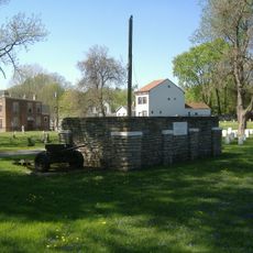
A cannon from the Grand Army of the Republic was brought to the cemetery in the 1920s as a veteran memorial and remains on the grounds today. This rare military monument makes the site a distinctive memorial space for soldiers from different conflicts.

The community of curious travelers

AroundUs brings together thousands of curated places, local tips, and hidden gems, enriched daily by 60,000 contributors worldwide.

Start exploring
Location
GPS coordinates
39.07420,-84.51510
Latest update
February 9, 2026 08:19
Around this place
Paycor Stadium
United States of America

Paycor Stadium

2.4 km
Riverfront Stadium
United States of America

Riverfront Stadium

2.6 km
John A. Roebling Suspension Bridge
United States of America

John A. Roebling Suspension Bridge

2.1 km
Brent Spence Bridge
United States of America

Brent Spence Bridge

2 km
Brady Music Center
United States of America

Brady Music Center

2.5 km
Cathedral Basilica of the Assumption
United States of America

Cathedral Basilica of the Assumption

763 m
The Ascent at Roebling's Bridge
United States of America

The Ascent at Roebling's Bridge

1.8 km
Clay Wade Bailey Bridge
United States of America

Clay Wade Bailey Bridge

1.9 km
Devou Park
United States of America

Devou Park

2.4 km
C&O Railroad Bridge
United States of America

C&O Railroad Bridge

2 km
Mother of God Roman Catholic Church
United States of America

Mother of God Roman Catholic Church

1.2 km
Daniel Carter Beard Boyhood Home
United States of America

Daniel Carter Beard Boyhood Home

1.9 km
Riverside Drive Historic District
United States of America

Riverside Drive Historic District

2 km
St. Augustine Church Complex
United States of America

St. Augustine Church Complex

918 m
Licking Riverside Historic District
United States of America

Licking Riverside Historic District

1.4 km
GAR Monument in Covington
United States of America

GAR Monument in Covington

87 m
Mutter Gottes Historic District
United States of America

Mutter Gottes Historic District

1.2 km
General James Taylor Park
United States of America

General James Taylor Park

2.3 km
Veteran's Monument in Covington
United States of America

Veteran's Monument in Covington

113 m
Odd Fellows Hall
United States of America

Odd Fellows Hall

1.4 km
Salem Methodist Episcopal Church and Parsonage
United States of America

Salem Methodist Episcopal Church and Parsonage

2.5 km
LaSalette Academy
United States of America

LaSalette Academy

1.3 km
York Street Historic District
United States of America

York Street Historic District

2.4 km
Monmouth Street Historic District
United States of America

Monmouth Street Historic District

2.5 km
Lewisburg Historic District
United States of America

Lewisburg Historic District

752 m
Newport Courthouse Square Historic District
United States of America

Newport Courthouse Square Historic District

2.5 km
St. Vincent de Paul School
United States of America

St. Vincent de Paul School

2.5 km
August Sauer House
United States of America

August Sauer House

2.2 km
Show the full map
« Linden Grove Cemetery - United States historic place in Kentucky » is provided by Around Us (aroundus.com). Images and texts are derived from Wikimedia project under a Creative Commons license. You are allowed to copy, distribute, and modify copies of this page, under the conditions set by the license, as long as this note is clearly visible.

Discover hidden gems everywhere you go!

From secret cafés to breathtaking viewpoints, skip the crowded tourist spots and find places that match your style. Our app makes it easy with voice search, smart filtering, route optimization, and insider tips from travelers worldwide. Download now for the complete mobile experience.

Around Us App Screenshot

A unique approach to discovering new places

Le Figaro

All the places worth exploring

France Info

A tailor-made excursion in just a few clicks

20 Minutes

Around Us
Travel Guide & Maps
Download

Send to your phone

QR Code
1

Open the camera app on your mobile.

2

Point at the QR code with your camera. A notification will appear.

3

Tap the notification to open the link.