Enable Location

We need your location to show you interesting places around you

Discover nearby places

Find interesting locations and hidden gems around you

Precise directions

Get accurate directions and distances to places

Your location is never shared with other users. It's only used when you tap the location button.

Clay Wade Bailey Bridge

Log in to your account

Start exploring — it's free

Trusted by 61,867 travelers worldwide

Continue with Google
Continue with Apple
or

We will send you a code to connect

By continuing, you accept our Terms and Conditions and our Privacy Policy

Check your inbox

We've sent a pincode in your inbox. Please enter the code below.

Clay Wade Bailey Bridge

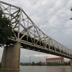
Clay Wade Bailey Bridge, Cantilever bridge in Covington, United States.

The Clay Wade Bailey Bridge is a cantilever bridge crossing the Ohio River between Covington, Kentucky and Cincinnati, Ohio. It carries six traffic lanes and serves as a major connection point between the two states.

Construction began in the early 1970s under the Kentucky Transportation Cabinet and opened to traffic in 1974. The project was built to address growing transportation demands between the two communities.

The structure is named after a newspaper reporter who advocated for better regional transportation links. You will notice the bridge is heavily used by commuters crossing between the two states daily.

Traffic is heaviest during morning and evening rush hours when commuters travel between the two cities. The bridge is open year-round, though winter weather can affect driving conditions.

The bridge uses a cantilever design that keeps support structures out of the water by distributing weight across extended horizontal beams. This approach was chosen to minimize disruption to the river below.

The community of curious travelers

AroundUs brings together thousands of curated places, local tips, and hidden gems, enriched daily by 60,000 contributors worldwide.

Start exploring
Location
Inception
October 1974
Official opening
October 1974
GPS coordinates
39.09110,-84.51930
Latest update
December 9, 2025 18:47
Around this place
Paycor Stadium
United States of America

Paycor Stadium

560 m
Riverfront Stadium
United States of America

Riverfront Stadium

1.1 km
John A. Roebling Suspension Bridge
United States of America

John A. Roebling Suspension Bridge

850 m
Carew Tower
United States of America

Carew Tower

1.2 km
Brent Spence Bridge
United States of America

Brent Spence Bridge

312 m
National Underground Railroad Freedom Center
United States of America

National Underground Railroad Freedom Center

1 km
Brady Music Center
United States of America

Brady Music Center

789 m
Ingalls Building
United States of America

Ingalls Building

1.2 km
The Ascent at Roebling's Bridge
United States of America

The Ascent at Roebling's Bridge

863 m
PNC Tower
United States of America

PNC Tower

1.1 km
Cincinnati Skywalk
United States of America

Cincinnati Skywalk

1.2 km
Scripps Center
United States of America

Scripps Center

1.2 km
C&O Railroad Bridge
United States of America

C&O Railroad Bridge

54 m
Mother of God Roman Catholic Church
United States of America

Mother of God Roman Catholic Church

838 m
Bartlett Building
United States of America

Bartlett Building

1.2 km
Daniel Carter Beard Boyhood Home
United States of America

Daniel Carter Beard Boyhood Home

1.2 km
John G. and Phyllis W. Smale Riverfront Park
United States of America

John G. and Phyllis W. Smale Riverfront Park

918 m
Riverside Drive Historic District
United States of America

Riverside Drive Historic District

1.1 km
John Church Company Building
United States of America

John Church Company Building

1.2 km
Lombardy Apartment Building
United States of America

Lombardy Apartment Building

904 m
H. W. Derby Building
United States of America

H. W. Derby Building

923 m
United States of America

United States Custom House and Post Office

1.1 km
Mutter Gottes Historic District
United States of America

Mutter Gottes Historic District

838 m
Hooper Building
United States of America

Hooper Building

1 km
Textile Building
United States of America

Textile Building

934 m
Odd Fellows Hall
United States of America

Odd Fellows Hall

960 m
Hilton Cincinnati Netherland Plaza
United States of America

Hilton Cincinnati Netherland Plaza

1.2 km
Cincinnati Reds Hall of Fame and Museum
United States of America

Cincinnati Reds Hall of Fame and Museum

1.2 km
Show the full map
« Clay Wade Bailey Bridge - Cantilever bridge in Covington, United States » is provided by Around Us (aroundus.com). Images and texts are derived from Wikimedia project under a Creative Commons license. You are allowed to copy, distribute, and modify copies of this page, under the conditions set by the license, as long as this note is clearly visible.

Discover hidden gems everywhere you go!

From secret cafés to breathtaking viewpoints, skip the crowded tourist spots and find places that match your style. Our app makes it easy with voice search, smart filtering, route optimization, and insider tips from travelers worldwide. Download now for the complete mobile experience.

Around Us App Screenshot

A unique approach to discovering new places

Le Figaro

All the places worth exploring

France Info

A tailor-made excursion in just a few clicks

20 Minutes

Around Us
Travel Guide & Maps
Download

Send to your phone

QR Code
1

Open the camera app on your mobile.

2

Point at the QR code with your camera. A notification will appear.

3

Tap the notification to open the link.