Enable Location

We need your location to show you interesting places around you

Discover nearby places

Find interesting locations and hidden gems around you

Precise directions

Get accurate directions and distances to places

Your location is never shared with other users. It's only used when you tap the location button.

Brent Spence Bridge

Log in to your account

Start exploring — it's free

Trusted by 61,523 travelers worldwide

Continue with Google
Continue with Apple
or

We will send you a code to connect

By continuing, you accept our Terms and Conditions and our Privacy Policy

Check your inbox

We've sent a pincode in your inbox. Please enter the code below.

Brent Spence Bridge

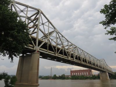
Brent Spence Bridge, Double-deck cantilever bridge in Covington, United States

Description

The Brent Spence Bridge is a cantilever structure with two levels crossing the Ohio River between Kentucky and Ohio on Interstates 71 and 75. Each level carries four lanes, with the upper deck heading toward Kentucky and the lower deck directing traffic to Ohio.

History

Opened on November 25, 1963, the crossing replaced an older span that could no longer meet the region's growing traffic needs. Its construction marked an important step in building the interstate highway system between the northern and southern United States.

Culture

Named after Kentucky Congressman Brent Spence, who championed infrastructure projects during his three decades in the U.S. Congress, this crossing reflects the region's commitment to interstate commerce. The structure links two distinct urban landscapes, with Cincinnati's skyline visible from one end and Covington's lower buildings from the other.

Practical

The upper deck directs traffic toward Kentucky while the lower deck carries vehicles into Ohio, so drivers should choose their approach before entering. The crossing sees heavy use throughout the day, so traveling outside rush hours can help avoid delays.

Did you know?

A new companion crossing west of the current structure is scheduled to open in 2032 to handle rising traffic volumes and will ease congestion along this section of the river. During construction, the older span will remain operational, ensuring continuous access between the two states.

Location
Inception
November 25, 1963
Official opening
November 25, 1963
GPS coordinates
39.09090,-84.52290
Latest update
December 20, 2025 11:39

AroundUs brings together thousands of curated places, local tips, and hidden gems, enriched daily by 60,000 contributors worldwide. Discover all places nearby (Kentucky).

Around this place
Paycor Stadium
United States of America

Paycor Stadium

779 m
Riverfront Stadium
United States of America

Riverfront Stadium

1.4 km
John A. Roebling Suspension Bridge
United States of America

John A. Roebling Suspension Bridge

1.2 km
National Underground Railroad Freedom Center
United States of America

National Underground Railroad Freedom Center

1.3 km
Brady Music Center
United States of America

Brady Music Center

1 km
Ingalls Building
United States of America

Ingalls Building

1.4 km
The Ascent at Roebling's Bridge
United States of America

The Ascent at Roebling's Bridge

1.2 km
PNC Tower
United States of America

PNC Tower

1.3 km
Cincinnati Skywalk
United States of America

Cincinnati Skywalk

1.4 km
Clay Wade Bailey Bridge
United States of America

Clay Wade Bailey Bridge

312 m
Bavarian Brewing Company
United States of America

Bavarian Brewing Company

1.6 km
C&O Railroad Bridge
United States of America

C&O Railroad Bridge

289 m
Mother of God Roman Catholic Church
United States of America

Mother of God Roman Catholic Church

1 km
Daniel Carter Beard Boyhood Home
United States of America

Daniel Carter Beard Boyhood Home

1.5 km
John G. and Phyllis W. Smale Riverfront Park
United States of America

John G. and Phyllis W. Smale Riverfront Park

1.2 km
Riverside Drive Historic District
United States of America

Riverside Drive Historic District

1.4 km
Lombardy Apartment Building
United States of America

Lombardy Apartment Building

1 km
Licking Riverside Historic District
United States of America

Licking Riverside Historic District

1.6 km
H. W. Derby Building
United States of America

H. W. Derby Building

1 km
United States of America

United States Custom House and Post Office

1.3 km
Mutter Gottes Historic District
United States of America

Mutter Gottes Historic District

1 km
Hooper Building
United States of America

Hooper Building

1.2 km
Textile Building
United States of America

Textile Building

1.1 km
Odd Fellows Hall
United States of America

Odd Fellows Hall

1.2 km
LaSalette Academy
United States of America

LaSalette Academy

1.6 km
Hilton Cincinnati Netherland Plaza
United States of America

Hilton Cincinnati Netherland Plaza

1.4 km
Cincinnati Reds Hall of Fame and Museum
United States of America

Cincinnati Reds Hall of Fame and Museum

1.5 km
Lewisburg Historic District
United States of America

Lewisburg Historic District

1.6 km
Show the full map
« Brent Spence Bridge - Double-deck cantilever bridge in Covington, United States » is provided by Around Us (aroundus.com). Images and texts are derived from Wikimedia project under a Creative Commons license. You are allowed to copy, distribute, and modify copies of this page, under the conditions set by the license, as long as this note is clearly visible.

Discover hidden gems everywhere you go!

From secret cafés to breathtaking viewpoints, skip the crowded tourist spots and find places that match your style. Our app makes it easy with voice search, smart filtering, route optimization, and insider tips from travelers worldwide. Download now for the complete mobile experience.

Around Us App Screenshot

A unique approach to discovering new places

Le Figaro

All the places worth exploring

France Info

A tailor-made excursion in just a few clicks

20 Minutes

Around Us
Travel Guide & Maps
Download

Send to your phone

QR Code
1

Open the camera app on your mobile.

2

Point at the QR code with your camera. A notification will appear.

3

Tap the notification to open the link.