Riverfront Stadium

Log in to your account

AroundUs is a community-driven map of interesting places, built by curious explorers like you. It grows with every review, story, and photo you share.
Connect to save your favorite spots, contribute locations, and create personalized routes.
By continuing, you accept our Terms and Conditions and our Privacy Policy

Riverfront Stadium

Add to collection
Map
Suggest a change
Share

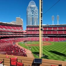
Riverfront Stadium, Multi-purpose stadium in downtown Cincinnati, US

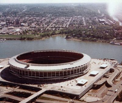
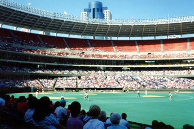
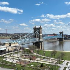
Riverfront Stadium was a multi-purpose sports facility in downtown Cincinnati along the Ohio River, operating from 1970 until 2002. The round building held four tiers of brightly colored seats that surrounded an artificial turf field used for both baseball and football matches.

Construction began in February 1968 following the award of an American Football League franchise to Cincinnati, with the opening taking place on June 30, 1970. A partial teardown removed around 14,000 seats in 2001 to make room for the replacement venue before the building was fully demolished in December 2002.

After a successful public referendum funded its construction, the sports venue became a gathering point where residents followed both major teams under one roof. Families across generations attended games by the waterfront, connecting the structure closely to local identity and civic pride.

The complex featured a three-level parking garage holding 2,500 spaces and used a rail system to shift seating layouts between baseball and football events. Visitors could easily reach the grounds from downtown, as it sat close to the city center along the riverbank.

The playing surface rested on a movable foundation that could be reconfigured at the push of a button within a few hours to switch between both sports. This mechanical conversion allowed baseball and football to take place on the same weekend without major delays.

Location: Cincinnati

Inception: June 30, 1970

Architects: Heery International

Official opening: June 30, 1970

Capacity: 2000

GPS coordinates: 39.09667,-84.50833

Latest update: December 13, 2025 17:31

Photos
Around this place
Heritage Bank Center
United States of America

Heritage Bank Center

358 m
National Underground Railroad Freedom Center
United States of America

National Underground Railroad Freedom Center

305 m
Great American Ball Park
United States of America

Great American Ball Park

160 m
Great American Tower at Queen City Square
United States of America

Great American Tower at Queen City Square

366 m
Brady Music Center
United States of America

Brady Music Center

444 m
Ingalls Building
United States of America

Ingalls Building

541 m
PNC Tower
United States of America

PNC Tower

514 m
Taylor–Southgate Bridge
United States of America

Taylor–Southgate Bridge

621 m
Fort Washington
United States of America

Fort Washington

326 m
Taft Theatre
United States of America

Taft Theatre

556 m
Scripps Center
United States of America

Scripps Center

348 m
Majestic
United States of America

Majestic

433 m
Mercantile Library of Cincinnati
United States of America

Mercantile Library of Cincinnati

538 m
PNC Center
United States of America

PNC Center

522 m
Statue of Abraham Lincoln
United States of America

Statue of Abraham Lincoln

610 m
Christ Church Cathedral, Cincinnati
United States of America

Christ Church Cathedral, Cincinnati

481 m
Bartlett Building
United States of America

Bartlett Building

488 m
Fourth & Walnut Center
United States of America

Fourth & Walnut Center

425 m
Reds Legends of Crosley Field
United States of America

Reds Legends of Crosley Field

171 m
John G. and Phyllis W. Smale Riverfront Park
United States of America

John G. and Phyllis W. Smale Riverfront Park

221 m
East Fourth Street Historic District
United States of America

East Fourth Street Historic District

611 m
John Church Company Building
United States of America

John Church Company Building

508 m
United States Custom House and Post Office
United States of America

United States Custom House and Post Office

514 m
Chiquita Center
United States of America

Chiquita Center

617 m
Cincinnati Reds Hall of Fame and Museum
United States of America

Cincinnati Reds Hall of Fame and Museum

104 m
Lytle Park
United States of America

Lytle Park

616 m
Lytle Park Historic District
United States of America

Lytle Park Historic District

561 m
Main and Third Street Cluster
United States of America

Main and Third Street Cluster

310 m
Show the full map
Reviews

Visited this place? Tap the stars to rate it and share your experience / photos with the community! Try now! You can cancel it anytime.

« Riverfront Stadium - Multi-purpose stadium in downtown Cincinnati, US » is provided by Around Us (aroundus.com). Images and texts are derived from Wikimedia project under a Creative Commons license. You are allowed to copy, distribute, and modify copies of this page, under the conditions set by the license, as long as this note is clearly visible.

Discover hidden gems everywhere you go!

From secret cafés to breathtaking viewpoints, skip the crowded tourist spots and find places that match your style. Our app makes it easy with voice search, smart filtering, route optimization, and insider tips from travelers worldwide. Download now for the complete mobile experience.

Around Us App Screenshot

A unique approach to discovering new places

Le Figaro

All the places worth exploring

France Info

A tailor-made excursion in just a few clicks

20 Minutes