Lockport Lock, Dam and Power House Historic District

Log in to your account

AroundUs is a community-driven map of interesting places, built by curious explorers like you. It grows with every review, story, and photo you share.
Connect to save your favorite spots, contribute locations, and create personalized routes.
Continue with Google
Continue with Apple
Continue with X
Continue with Facebook
Continue with email
By continuing, you accept our Terms and Conditions and our Privacy Policy
Create an account
Add to collection
Map
Suggest a change
Share

Lockport Lock, Dam and Power House Historic District, Hydroelectric power station and lock system in Lockport Township, United States.

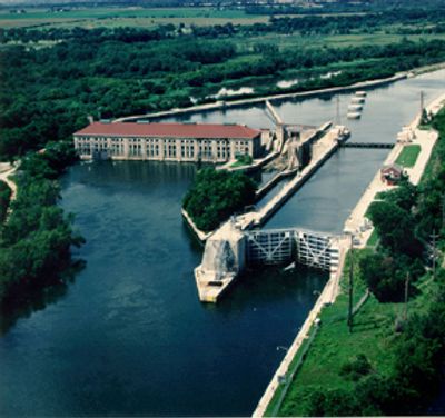
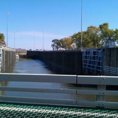
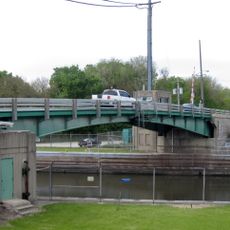
Lockport Lock, Dam and Power House is an engineering complex that combines a navigation lock with roughly a 12-meter drop, a dam for water control, and a powerhouse. The facility uses water to generate electricity while also allowing barge traffic to pass through the lock.

The complex was built between 1905 and 1907 and marked the completion of the Chicago Sanitary and Ship Canal, which connected Lake Michigan to the Mississippi River. This project was one of the greatest engineering achievements of its time and fundamentally changed water management in the region.

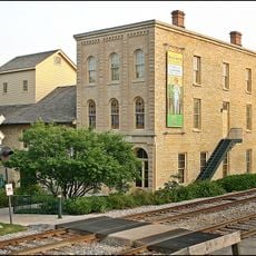
The powerhouse displays classical architectural style with concrete blocks designed to resemble stone and a red roof. The structure shapes the local landscape and shows how engineering works can also be visually composed.

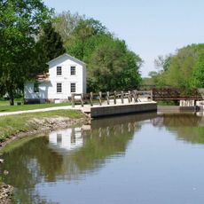
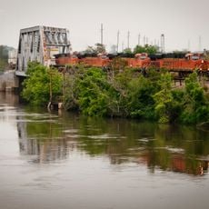
The facility sits adjacent to the Chicago Sanitary and Ship Canal and is accessible from nearby roads that allow you to view the structure from the outside. Several vantage points in the area offer views of the lock and water control, especially when barges pass through.

The powerhouse uses two vertical Kaplan turbines, which were specifically developed to handle variable water flows. These turbines allow the facility to operate efficiently despite changing water volumes that vary with season and rainfall.

Location: Lockport Township

GPS coordinates: 41.56940,-88.07890

Latest update: December 12, 2025 07:55

Photos
Around this place
Stateville Correctional Center
United States of America

Stateville Correctional Center

1.6 km
Joliet Correctional Center
United States of America

Joliet Correctional Center

2.5 km
Illinois and Michigan Canal
United States of America

Illinois and Michigan Canal

765 m
Chicagoland Speedway
United States of America

Chicagoland Speedway

10.7 km
Harrah's Joliet
United States of America

Harrah's Joliet

4.7 km
Rialto Square Theatre
United States of America

Rialto Square Theatre

4.8 km
Cathedral of St. Raymond Nonnatus
United States of America

Cathedral of St. Raymond Nonnatus

4.2 km
Hiram B. Scutt Mansion
United States of America

Hiram B. Scutt Mansion

4.8 km
United States of America

Argosy Empress Casino

11.5 km
Joliet East Side Historic District
United States of America

Joliet East Side Historic District

5.6 km
Des Plaines River Valley Bridge
United States of America

Des Plaines River Valley Bridge

12.2 km
Gaylord Building
United States of America

Gaylord Building

3 km
Brandon Road Lock and Dam
United States of America

Brandon Road Lock and Dam

7.6 km
Standard Oil Gasoline Station
United States of America

Standard Oil Gasoline Station

11.4 km
Stone Manor
United States of America

Stone Manor

11.9 km
Christ Episcopal Church
United States of America

Christ Episcopal Church

4.9 km
Joliet YMCA
United States of America

Joliet YMCA

4.3 km
Downtown Plainfield Historic District
United States of America

Downtown Plainfield Historic District

11.4 km
Flanders House
United States of America

Flanders House

11.4 km
Fitzpatrick House
United States of America

Fitzpatrick House

3.5 km
Upper Bluff Historic District
United States of America

Upper Bluff Historic District

4.7 km
United States Post Office
United States of America

United States Post Office

4.7 km
Lockport Historic District
United States of America

Lockport Historic District

2.9 km
Robert Milne House
United States of America

Robert Milne House

3.3 km
Ron George Round Barn
United States of America

Ron George Round Barn

8.2 km
John Heck House
United States of America

John Heck House

2.5 km
Brandon Road Bridge
United States of America

Brandon Road Bridge

7.8 km
BNSF - I&M Canal Bridge
United States of America

BNSF - I&M Canal Bridge

3.4 km
Show the full map
Reviews

Visited this place? Tap the stars to rate it and share your experience / photos with the community! Try now! You can cancel it anytime.

« Lockport Lock, Dam and Power House Historic District - Hydroelectric power station and lock system in Lockport Township, United States » is provided by Around Us (aroundus.com). Images and texts are derived from Wikimedia project under a Creative Commons license. You are allowed to copy, distribute, and modify copies of this page, under the conditions set by the license, as long as this note is clearly visible.

Discover hidden gems everywhere you go!

From secret cafés to breathtaking viewpoints, skip the crowded tourist spots and find places that match your style. Our app makes it easy with voice search, smart filtering, route optimization, and insider tips from travelers worldwide. Download now for the complete mobile experience.

Around Us App Screenshot

A unique approach to discovering new places

Le Figaro

All the places worth exploring

France Info

A tailor-made excursion in just a few clicks

20 Minutes