Enable Location

We need your location to show you interesting places around you

Discover nearby places

Find interesting locations and hidden gems around you

Precise directions

Get accurate directions and distances to places

Your location is never shared with other users. It's only used when you tap the location button.

Mayo River State Park

Log in to your account

Start exploring — it's free

Trusted by 61,962 travelers worldwide

Continue with Google
Continue with Apple
or

We will send you a code to connect

By continuing, you accept our Terms and Conditions and our Privacy Policy

Check your inbox

We've sent a pincode in your inbox. Please enter the code below.

Mayo River State Park

Mayo River State Park, Nature park in Rockingham County, United States.

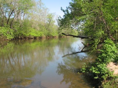
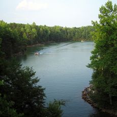
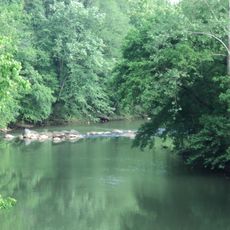
Mayo River State Park is a nature preserve in Rockingham County featuring hiking trails that run along the river's banks and designated fishing areas. The park provides picnic facilities and multiple entry points that allow visitors to access different sections of the waterway.

The park grew out of an initiative by the Dan River Basin Association that led to formal authorization by the North Carolina General Assembly. This recognition in 2003 transformed the river area into a protected public space.

The park functions as an educational center where staff members conduct programs about North Carolina's natural environment through interpretive sessions.

The park opens daily at 8 AM and closes at dusk with closing times varying by season. There is no entrance fee for day visits, making it a free option for all visitors.

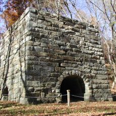
The park features four distinct access points named Deshazo Mill, Anglin Mill, Hickory Creek, and Mayodan, each offering a different gateway to the river valley. These varied entry points lead to Class II rapids where water sports enthusiasts can paddle.

The community of curious travelers

AroundUs brings together thousands of curated places, local tips, and hidden gems, enriched daily by 60,000 contributors worldwide.

Start exploring
Inception
2003
GPS coordinates
36.43880,-79.93820
Latest update
December 13, 2025 11:43
Around this place
Martinsville Speedway
United States of America

Martinsville Speedway

23.1 km
Belews Lake
United States of America

Belews Lake

17.9 km
Penn House
United States of America

Penn House

25.7 km
Moratock Park
United States of America

Moratock Park

23.6 km
Martinsville Fish Dam
United States of America

Martinsville Fish Dam

24.6 km
John D. Bassett High School
United States of America

John D. Bassett High School

20.9 km
United States of America

Mt. Sinai Baptist Church

16.4 km
Spray Industrial Historic District
United States of America

Spray Industrial Historic District

18.2 km
First Baptist Church
United States of America

First Baptist Church

16.8 km
Leaksville Commercial Historic District
United States of America

Leaksville Commercial Historic District

16.6 km
Washington Mills-Mayodan Plant
United States of America

Washington Mills-Mayodan Plant

4.1 km
Grassdale Farm
United States of America

Grassdale Farm

20.8 km
Pine Hall
United States of America

Pine Hall

15.5 km
Sardis Primitive Baptist Church
United States of America

Sardis Primitive Baptist Church

11.9 km
Aurora
United States of America

Aurora

20.8 km
United States of America

Wentworth Methodist Episcopal Church and Cemetery

15 km
Former Reidsville High School
United States of America

Former Reidsville High School

25.4 km
Jennings-Baker House
United States of America

Jennings-Baker House

25.1 km
Dr. Franklin King House-Idlewild
United States of America

Dr. Franklin King House-Idlewild

16.9 km
First Baptist Church
United States of America

First Baptist Church

6.2 km
Gov. David S. Reid House
United States of America

Gov. David S. Reid House

26.2 km
Danbury Historic District
United States of America

Danbury Historic District

24.3 km
Alfred Moore Scales Law Office
United States of America

Alfred Moore Scales Law Office

5.7 km
North Washington Avenue Workers' House
United States of America

North Washington Avenue Workers' House

25.3 km
Stokes County Courthouse
United States of America

Stokes County Courthouse

24.2 km
Academy Street Historic District
United States of America

Academy Street Historic District

6.3 km
Spencer-Penn School
United States of America

Spencer-Penn School

20.9 km
Ingleside
United States of America

Ingleside

19 km
Show the full map
« Mayo River State Park - Nature park in Rockingham County, United States » is provided by Around Us (aroundus.com). Images and texts are derived from Wikimedia project under a Creative Commons license. You are allowed to copy, distribute, and modify copies of this page, under the conditions set by the license, as long as this note is clearly visible.

Discover hidden gems everywhere you go!

From secret cafés to breathtaking viewpoints, skip the crowded tourist spots and find places that match your style. Our app makes it easy with voice search, smart filtering, route optimization, and insider tips from travelers worldwide. Download now for the complete mobile experience.

Around Us App Screenshot

A unique approach to discovering new places

Le Figaro

All the places worth exploring

France Info

A tailor-made excursion in just a few clicks

20 Minutes

Around Us
Travel Guide & Maps
Download

Send to your phone

QR Code
1

Open the camera app on your mobile.

2

Point at the QR code with your camera. A notification will appear.

3

Tap the notification to open the link.