Enable Location

We need your location to show you interesting places around you

Discover nearby places

Find interesting locations and hidden gems around you

Precise directions

Get accurate directions and distances to places

Your location is never shared with other users. It's only used when you tap the location button.

McKinley School

Log in to your account

Start exploring — it's free

Trusted by 62,164 travelers worldwide

Continue with Google
Continue with Apple
or

We will send you a code to connect

By continuing, you accept our Terms and Conditions and our Privacy Policy

Check your inbox

We've sent a pincode in your inbox. Please enter the code below.

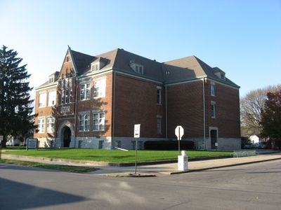
McKinley School, listed on the National Register of Historic Places

McKinley School is a school building in Columbus, Indiana, constructed in 1892 in the Richardsonian Romanesque style. It features red brick walls, a limestone foundation, and distinctive large rounded arches at its entrances, with an addition from 1942 that added more classroom space.

The school was built in 1892 by architect Charles F. Sparrell as one of the first public schools to serve the city's growing population on the north side. It was renamed McKinley School between 1903 and 1915 to honor President William McKinley.

The school was named to honor President William McKinley after his assassination in 1901. For nearly a century, it served as a gathering place where generations of Columbus children learned and grew up together.

The building is located at the corner of Seventeenth Street and Home Avenue in Columbus and is easily visible from the street. Today it functions as apartments rather than a school, so interior access is limited, but the exterior Romanesque architecture remains fully viewable.

The building was designed by Charles F. Sparrell, a local architect who also shaped Columbus City Hall and influenced the Richardsonian Romanesque style across the region. It was added to the National Register of Historic Places in 1988, making it one of the few intact school buildings from this era still standing in Indiana.

The community of curious travelers

AroundUs brings together thousands of curated places, local tips, and hidden gems, enriched daily by 60,000 contributors worldwide.

Start exploring
Location
GPS coordinates
39.21583,-85.91222
Latest update
February 7, 2026 11:00
Around this place
Camp Atterbury
United States of America

Camp Atterbury

13.8 km
Miller House and Garden
United States of America

Miller House and Garden

1.6 km
North Christian Church
United States of America

North Christian Church

1.5 km
First Christian Church
United States of America

First Christian Church

1.5 km
Cleo Rogers Memorial Library
United States of America

Cleo Rogers Memorial Library

1.4 km
Irwin Conference Center
United States of America

Irwin Conference Center

1.6 km
Crump Theatre
United States of America

Crump Theatre

1.8 km
United States of America

The Republic Newspaper Office

1.9 km
United States of America

Mill Race Park

1.8 km
Bartholomew County Courthouse
United States of America

Bartholomew County Courthouse

1.8 km
The Arch
United States of America

The Arch

1.5 km
Mabel McDowell Adult Education Center
United States of America

Mabel McDowell Adult Education Center

2.3 km
Columbus Power House
United States of America

Columbus Power House

2.1 km
Columbus Historic District
United States of America

Columbus Historic District

1.2 km
Grandview Apostolic Church
United States of America

Grandview Apostolic Church

18 km
McEwen-Samuels-Marr House
United States of America

McEwen-Samuels-Marr House

1.7 km
New Hope Bridge
United States of America

New Hope Bridge

4.9 km
Columbus City Hall
United States of America

Columbus City Hall

1.6 km
Brownsville Covered Bridge
United States of America

Brownsville Covered Bridge

1.9 km
Bartholomew County Annex building
United States of America

Bartholomew County Annex building

2.4 km
South Walnut Street Historic District
United States of America

South Walnut Street Historic District

15.8 km
Pugh Ford Bridge
United States of America

Pugh Ford Bridge

13.8 km
Furnas Mill Bridge
United States of America

Furnas Mill Bridge

19.9 km
Toner Historic District
United States of America

Toner Historic District

16 km
David Aikens House
United States of America

David Aikens House

4.9 km
Robert N. Stewart Bridge
United States of America

Robert N. Stewart Bridge

2.2 km
Jonathan Moore Pike I-65 Bridge
United States of America

Jonathan Moore Pike I-65 Bridge

4.3 km
Clifty Creek Bridge
United States of America

Clifty Creek Bridge

5 km
Show the full map
« McKinley School - listed on the National Register of Historic Places » is provided by Around Us (aroundus.com). Images and texts are derived from Wikimedia project under a Creative Commons license. You are allowed to copy, distribute, and modify copies of this page, under the conditions set by the license, as long as this note is clearly visible.

Discover hidden gems everywhere you go!

From secret cafés to breathtaking viewpoints, skip the crowded tourist spots and find places that match your style. Our app makes it easy with voice search, smart filtering, route optimization, and insider tips from travelers worldwide. Download now for the complete mobile experience.

Around Us App Screenshot

A unique approach to discovering new places

Le Figaro

All the places worth exploring

France Info

A tailor-made excursion in just a few clicks

20 Minutes

Around Us
Travel Guide & Maps
Download

Send to your phone

QR Code
1

Open the camera app on your mobile.

2

Point at the QR code with your camera. A notification will appear.

3

Tap the notification to open the link.