Enable Location

We need your location to show you interesting places around you

Discover nearby places

Find interesting locations and hidden gems around you

Precise directions

Get accurate directions and distances to places

Your location is never shared with other users. It's only used when you tap the location button.

Moggy Hollow Natural Area

Log in to your account

Start exploring — it's free

Trusted by 63,591 travelers worldwide

Continue with Google
Continue with Apple
or

We will send you a code to connect

By continuing, you accept our Terms and Conditions and our Privacy Policy

Check your inbox

We've sent a pincode in your inbox. Please enter the code below.

Moggy Hollow Natural Area
Discussion Reviews 1 Photos
1.2k Popularity

Moggy Hollow Natural Area, Natural landmark in Somerset County, United States.

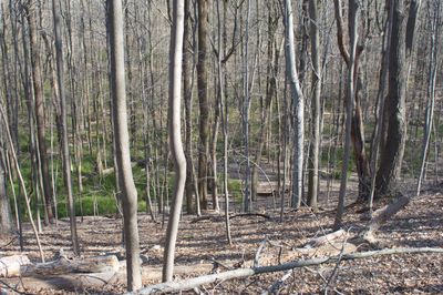
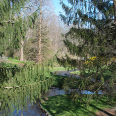
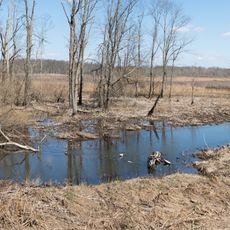
Moggy Hollow Natural Area is a protected natural landmark in Somerset County featuring a steep ravine carved through rock formations with a flowing stream and wetland at its base. The site displays layered geology and vegetation adapted to the moist, sheltered conditions within the hollow.

This location served as an outlet for Glacial Lake Passaic during the Wisconsin Glacial Stage roughly 50,000 years ago, with water flowing through the site for over 2,000 years. The persistent erosive action of this ancient waterway carved the deep ravine that exists today.

The land was donated by J. Malcolm Belcher, former Far Hills mayor, to the Raritan Headwaters Association for scientific and educational purposes.

Access to the upper ledge is available from Liberty Corner Road, while visiting the lower section requires permission to cross the nearby Leonard J. Buck Garden. Proper footwear with good grip is essential since the terrain is steep and surfaces become slippery after rain.

The site was donated by J. Malcolm Belcher, a former mayor of Far Hills, to the Raritan Headwaters Association specifically for scientific research and education. This gift of private land helped ensure this geological formation would be protected for future study and discovery.

The community of curious travelers

AroundUs brings together thousands of curated places, local tips, and hidden gems, enriched daily by 60,000 contributors worldwide.

Start exploring
Location
GPS coordinates
40.67350,-74.61410
Latest update
December 9, 2025 20:28
Around this place
Devil's Tree
United States of America

Devil's Tree

5.5 km
United States of America

Sri Venkateswara Temple

5.4 km
Blairsden
United States of America

Blairsden

4.9 km
USGA Museum
United States of America

USGA Museum

842 m
United States of America

Far Hills Races

2.4 km
Basking Ridge White Oak Tree
United States of America

Basking Ridge White Oak Tree

6.6 km
Willowwood Arboretum
United States of America

Willowwood Arboretum

9.3 km
Jacobus Vanderveer House
United States of America

Jacobus Vanderveer House

3.2 km
Leonard J. Buck Garden
United States of America

Leonard J. Buck Garden

703 m
Lord Stirling Park
United States of America

Lord Stirling Park

6.6 km
Presbyterian Church in Basking Ridge
United States of America

Presbyterian Church in Basking Ridge

6.6 km
Lord Stirling Manor Site
United States of America

Lord Stirling Manor Site

7.4 km
Brick Academy
United States of America

Brick Academy

6.6 km
John Parker Tavern
United States of America

John Parker Tavern

6.3 km
Mount Bethel Baptist Meetinghouse
United States of America

Mount Bethel Baptist Meetinghouse

9.3 km
Pluckemin Village Historic District
United States of America

Pluckemin Village Historic District

3.7 km
Boudinot-Southard Farmstead
United States of America

Boudinot-Southard Farmstead

7.6 km
St. Bernard's Church and Parish House
United States of America

St. Bernard's Church and Parish House

6.5 km
Lamington Historic District
United States of America

Lamington Historic District

8.8 km
Jacob Vosseller House
United States of America

Jacob Vosseller House

7.4 km
Reynolds-Scherman House
United States of America

Reynolds-Scherman House

8.8 km
Kennedy-Martin-Stelle Farmstead
United States of America

Kennedy-Martin-Stelle Farmstead

7.4 km
Natirar
United States of America

Natirar

4.2 km
Basking Ridge Presbyterian Church Cemetery
United States of America

Basking Ridge Presbyterian Church Cemetery

6.6 km
Olcott Avenue Historic District
United States of America

Olcott Avenue Historic District

6.7 km
Franklin Corners Historic District
United States of America

Franklin Corners Historic District

8.7 km
Liberty Corner Historic District
United States of America

Liberty Corner Historic District

3 km
Van Dorn's Mill
United States of America

Van Dorn's Mill

9 km
Show the full map
Reviews
Share your experience

No review yet

Discussions
Start a discussion...

No discussion yet

« Moggy Hollow Natural Area - Natural landmark in Somerset County, United States » is provided by Around Us (aroundus.com). Images and texts are derived from Wikimedia project under a Creative Commons license. You are allowed to copy, distribute, and modify copies of this page, under the conditions set by the license, as long as this note is clearly visible.

Discover hidden gems everywhere you go!

From secret cafés to breathtaking viewpoints, skip the crowded tourist spots and find places that match your style. Our app makes it easy with voice search, smart filtering, route optimization, and insider tips from travelers worldwide. Download now for the complete mobile experience.

Around Us App Screenshot

A unique approach to discovering new places

Le Figaro

All the places worth exploring

France Info

A tailor-made excursion in just a few clicks

20 Minutes

Around Us
Travel Guide & Maps
Download

Send to your phone

QR Code
1

Open the camera app on your mobile.

2

Point at the QR code with your camera. A notification will appear.

3

Tap the notification to open the link.