Enable Location

We need your location to show you interesting places around you

Discover nearby places

Find interesting locations and hidden gems around you

Precise directions

Get accurate directions and distances to places

Your location is never shared with other users. It's only used when you tap the location button.

Morgan–Monroe State Forest

Log in to your account

Start exploring — it's free

Trusted by 63,022 travelers worldwide

Continue with Google
Continue with Apple
or

We will send you a code to connect

By continuing, you accept our Terms and Conditions and our Privacy Policy

Check your inbox

We've sent a pincode in your inbox. Please enter the code below.

Morgan–Monroe State Forest
Discussion Reviews 1 Photos
3.6k Popularity

Morgan–Monroe State Forest, Protected forest in Morgan and Monroe counties, Indiana.

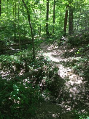
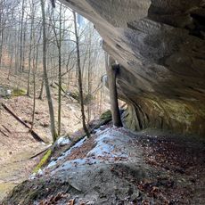
Morgan-Monroe State Forest is a protected area spanning approximately 24,500 acres across south-central Indiana in two counties. The land features steep ridges, deep valleys, and extensive hardwood forests that provide habitats for many wildlife species.

Starting in 1929, Indiana began purchasing eroded and abandoned farmland from early settlers who could not cultivate the rocky soil. This acquired land became the foundation for the protected forest that exists today.

The forest office features educational displays incorporating 17 wood species, teaching visitors about property history, ecological features, wildlife, and forest management techniques.

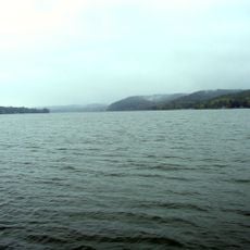
The forest contains three lakes with boat ramps that allow fishing with valid licenses and other water activities. Visitors should expect steep terrain and hilly conditions throughout the property.

The forest permits gold panning activities with special permits, an activity that many other protected areas in Indiana do not allow. Visitors interested in this uncommon pursuit can inquire locally about the required permits.

The community of curious travelers

AroundUs brings together thousands of curated places, local tips, and hidden gems, enriched daily by 60,000 contributors worldwide.

Start exploring
Location
GPS coordinates
39.32110,-86.41330
Latest update
December 12, 2025 07:51
Around this place
Memorial Stadium
United States of America

Memorial Stadium

18.4 km
Eskenazi Museum of Art
United States of America

Eskenazi Museum of Art

19.2 km
Yellowwood State Forest
United States of America

Yellowwood State Forest

12.4 km
United States of America

Griffy Lake

16.2 km
John Mellencamp Pavilion
United States of America

John Mellencamp Pavilion

18.1 km
Millen House
United States of America

Millen House

19 km
Maple Grove Road Rural Historic District
United States of America

Maple Grove Road Rural Historic District

17 km
Indiana University Auditorium
United States of America

Indiana University Auditorium

19.2 km
Hite-Finney House
United States of America

Hite-Finney House

12 km
Morgan County Public Library
United States of America

Morgan County Public Library

11.7 km
Morgan County Courthouse
United States of America

Morgan County Courthouse

11.9 km
East Washington Street Historic District
United States of America

East Washington Street Historic District

11.8 km
Brown County Courthouse Historic District
United States of America

Brown County Courthouse Historic District

19.1 km
Crawford-Gilpin House
United States of America

Crawford-Gilpin House

11.7 km
Morgantown Historic District
United States of America

Morgantown Historic District

14.3 km
Martinsville Commercial Historic District
United States of America

Martinsville Commercial Historic District

11.9 km
Brown County Bridge No. 36
United States of America

Brown County Bridge No. 36

18.1 km
Daniel Stout House
United States of America

Daniel Stout House

18.1 km
Blackstone House and Martinsville Telephone Company Building
United States of America

Blackstone House and Martinsville Telephone Company Building

11.7 km
Lamb's Creek Bridge
United States of America

Lamb's Creek Bridge

12.6 km
Blankenship-Hodges-Brown House
United States of America

Blankenship-Hodges-Brown House

15.6 km
Neely House
United States of America

Neely House

12 km
Martinsville Northside Historic District
United States of America

Martinsville Northside Historic District

12.2 km
Bean Blossom Covered Bridge
United States of America

Bean Blossom Covered Bridge

15.2 km
Lake Lemon
United States of America

Lake Lemon

7.2 km
Brown County Art Guild
United States of America

Brown County Art Guild

19.2 km
Low Gap Trail
United States of America

Low Gap Trail

1.5 km
Blackstone House and Martinsville Telephone Company Building
United States of America

Blackstone House and Martinsville Telephone Company Building

11.7 km
Show the full map
Reviews
Share your experience

No review yet

Discussions
Start a discussion...

No discussion yet

« Morgan–Monroe State Forest - Protected forest in Morgan and Monroe counties, Indiana » is provided by Around Us (aroundus.com). Images and texts are derived from Wikimedia project under a Creative Commons license. You are allowed to copy, distribute, and modify copies of this page, under the conditions set by the license, as long as this note is clearly visible.

Discover hidden gems everywhere you go!

From secret cafés to breathtaking viewpoints, skip the crowded tourist spots and find places that match your style. Our app makes it easy with voice search, smart filtering, route optimization, and insider tips from travelers worldwide. Download now for the complete mobile experience.

Around Us App Screenshot

A unique approach to discovering new places

Le Figaro

All the places worth exploring

France Info

A tailor-made excursion in just a few clicks

20 Minutes

Around Us
Travel Guide & Maps
Download

Send to your phone

QR Code
1

Open the camera app on your mobile.

2

Point at the QR code with your camera. A notification will appear.

3

Tap the notification to open the link.