Enable Location

We need your location to show you interesting places around you

Discover nearby places

Find interesting locations and hidden gems around you

Precise directions

Get accurate directions and distances to places

Your location is never shared with other users. It's only used when you tap the location button.

Mount Oglethorpe

Log in to your account

Start exploring — it's free

Trusted by 63,119 travelers worldwide

Continue with Google
Continue with Apple
or

We will send you a code to connect

By continuing, you accept our Terms and Conditions and our Privacy Policy

Check your inbox

We've sent a pincode in your inbox. Please enter the code below.

Mount Oglethorpe
Discussion Reviews 1 Photos
8.5k Popularity

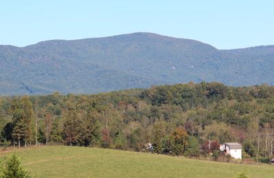
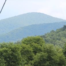
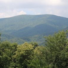
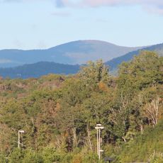
Mount Oglethorpe, Mountain summit in Pickens County, United States.

Mount Oglethorpe in Pickens County rises to an elevation of 3,288 feet and stands as the highest point in the surrounding region and the Atlanta Metropolitan Area. The summit offers clear views across the landscape and connects to a network of trails for exploration.

The mountain served as the southern terminus of the Appalachian Trail starting in 1937, a role it held until 1958 when the trail was relocated to Springer Mountain due to development pressures. This shift reflected changing conditions along one of America's most famous long-distance hiking routes.

The mountain is named after an early colonial figure and held significance for the Cherokee people who traveled through this region. Today visitors walking the trails encounter a landscape shaped by both indigenous and settler histories.

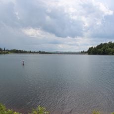
The mountain can be reached through multiple access points including Eagle's Rest Park, which connects from Georgia State Route 136 or through the community of Big Canoe. Visitors should wear sturdy footwear and check conditions before heading out, as the summit offers exposure to weather.

The mountain contains marble quarries on its southern slopes that reveal the region's industrial past. The residential communities nestled into the landscape add an unexpected human element to the natural setting.

The community of curious travelers

AroundUs brings together thousands of curated places, local tips, and hidden gems, enriched daily by 60,000 contributors worldwide.

Start exploring
Location
GPS coordinates
34.48625,-84.33143
Latest update
December 10, 2025 16:02
Around this place
Amicalola Falls State Park
United States of America

Amicalola Falls State Park

12 km
Springer Mountain
United States of America

Springer Mountain

20.1 km
Carters Lake
United States of America

Carters Lake

30.8 km
Amicalola Falls
United States of America

Amicalola Falls

12.1 km
Tate House
United States of America

Tate House

9 km
United States of America

Long Swamp Site

18.6 km
Spaceship Earth
United States of America

Spaceship Earth

30.6 km
Black Mountain
United States of America

Black Mountain

18.3 km
Rich Mountain Wilderness
United States of America

Rich Mountain Wilderness

27.2 km
Big Bald Mountain
United States of America

Big Bald Mountain

29.5 km
Pool's Mill Covered Bridge
United States of America

Pool's Mill Covered Bridge

23.2 km
Rich Mountain
United States of America

Rich Mountain

28.7 km
Hickory Log Creek Dam
United States of America

Hickory Log Creek Dam

27.7 km
Ed Jenkins National Recreation Area
United States of America

Ed Jenkins National Recreation Area

20.3 km
Funk Heritage Center
United States of America

Funk Heritage Center

27.2 km
United States of America

Georgia Racing Hall of Fame

21.5 km
Georgia Marble Company and Tate Historic District
United States of America

Georgia Marble Company and Tate Historic District

9.7 km
Cagle House
United States of America

Cagle House

14.4 km
Gilmer County Courthouse
United States of America

Gilmer County Courthouse

27.1 km
Griffeth-Pendley House
United States of America

Griffeth-Pendley House

6.1 km
Dawsonville Pool Room
United States of America

Dawsonville Pool Room

20.9 km
Dawson County Courthouse
United States of America

Dawson County Courthouse

20.8 km
Red Apple Barn
United States of America

Red Apple Barn

30.2 km
Boyd and Sallie Gilleland House
United States of America

Boyd and Sallie Gilleland House

20.9 km
Ball Ground Historic District
United States of America

Ball Ground Historic District

16.9 km
Pickens County Courthouse
United States of America

Pickens County Courthouse

9.1 km
Tate Gymnasium
United States of America

Tate Gymnasium

8.9 km
Canton Historic District
United States of America

Canton Historic District

31.3 km
Show the full map
Reviews
Share your experience

No review yet

Discussions
Start a discussion...

No discussion yet

« Mount Oglethorpe - Mountain summit in Pickens County, United States » is provided by Around Us (aroundus.com). Images and texts are derived from Wikimedia project under a Creative Commons license. You are allowed to copy, distribute, and modify copies of this page, under the conditions set by the license, as long as this note is clearly visible.

Discover hidden gems everywhere you go!

From secret cafés to breathtaking viewpoints, skip the crowded tourist spots and find places that match your style. Our app makes it easy with voice search, smart filtering, route optimization, and insider tips from travelers worldwide. Download now for the complete mobile experience.

Around Us App Screenshot

A unique approach to discovering new places

Le Figaro

All the places worth exploring

France Info

A tailor-made excursion in just a few clicks

20 Minutes

Around Us
Travel Guide & Maps
Download

Send to your phone

QR Code
1

Open the camera app on your mobile.

2

Point at the QR code with your camera. A notification will appear.

3

Tap the notification to open the link.