Springer Mountain

Log in to your account

AroundUs is a community-driven map of interesting places, built by curious explorers like you. It grows with every review, story, and photo you share.
Connect to save your favorite spots, contribute locations, and create personalized routes.
By continuing, you accept our Terms and Conditions and our Privacy Policy
Add to collection
Map
Suggest a change
Share

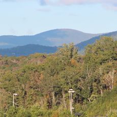
Springer Mountain, Mountain summit in Georgia, United States

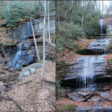
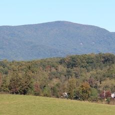
Springer Mountain is a summit in the Chattahoochee National Forest located on the border between Fannin and Gilmer counties, with rocky terrain and dense forest coverage. The peak sits at approximately 3,770 feet (1,148 meters) and serves as a natural gateway to the trail system extending through the forest.

Until 1958, Mount Oglethorpe served as the southern terminus of the Appalachian Trail, but extensive development near that location led to the relocation of this important endpoint. Since then, this mountain has marked the official southern boundary of the long-distance hiking route.

The mountain takes its name from William G. Springer, who worked on Native American legislation, or from John Springer, the first Presbyterian minister in Georgia. This naming reflects the local connection to figures who shaped the region's history.

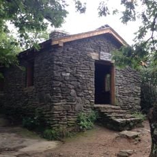
Visitors can access the summit via white-blazed trails starting from the parking area at Forest Service Road 42, which leads through the woods to the peak. The route is short and manageable, allowing hikers of different abilities to reach the top without extensive time commitment.

A bronze plaque at the summit marks the southern starting point of the Appalachian Trail, one of North America's most famous long-distance hiking routes. Many hikers who attempt to walk the entire route begin their journey here, viewing the marker as a symbolic beginning to their expedition.

Location: Georgia

Elevation above the sea: 1,148 m

GPS coordinates: 34.62665,-84.19353

Latest update: December 7, 2025 09:20

Photos
Around this place
Amicalola Falls State Park
United States of America

Amicalola Falls State Park

8.2 km
Blood Mountain
United States of America

Blood Mountain

26.6 km
Amicalola Falls
United States of America

Amicalola Falls

8.1 km
Lake Blue Ridge
United States of America

Lake Blue Ridge

25.4 km
DeSoto Falls
United States of America

DeSoto Falls

27 km
Mount Oglethorpe
United States of America

Mount Oglethorpe

20.1 km
Consolidated Gold Mine
United States of America

Consolidated Gold Mine

22.7 km
Lake Winfield Scott
United States of America

Lake Winfield Scott

23.6 km
Blood Mountain Wilderness
United States of America

Blood Mountain Wilderness

26.7 km
Dahlonega Gold Museum Historic Site
United States of America

Dahlonega Gold Museum Historic Site

21.8 km
Black Mountain
United States of America

Black Mountain

1.8 km
Rich Mountain Wilderness
United States of America

Rich Mountain Wilderness

17.7 km
Big Bald Mountain
United States of America

Big Bald Mountain

18.1 km
Slaughter Mountain
United States of America

Slaughter Mountain

26 km
Rich Mountain
United States of America

Rich Mountain

18.9 km
Ed Jenkins National Recreation Area
United States of America

Ed Jenkins National Recreation Area

949 m
Three Sisters
United States of America

Three Sisters

23.1 km
United States of America

Shallowford Bridge

18.5 km
Price Memorial Hall
United States of America

Price Memorial Hall

21.8 km
United States of America

Georgia Racing Hall of Fame

24.4 km
Holly Theatre
United States of America

Holly Theatre

21.8 km
Dockery Lake Recreation Area
United States of America

Dockery Lake Recreation Area

20.7 km
Griffeth-Pendley House
United States of America

Griffeth-Pendley House

25.7 km
Dawsonville Pool Room
United States of America

Dawsonville Pool Room

23.9 km
Dawson County Courthouse
United States of America

Dawson County Courthouse

23.9 km
Boyd and Sallie Gilleland House
United States of America

Boyd and Sallie Gilleland House

24.2 km
Fields Place-Vickery House
United States of America

Fields Place-Vickery House

21.7 km
Chestatee River Diving Bell
United States of America

Chestatee River Diving Bell

21.7 km
Show the full map
Reviews

Visited this place? Tap the stars to rate it and share your experience / photos with the community! Try now! You can cancel it anytime.

« Springer Mountain - Mountain summit in Georgia, United States » is provided by Around Us (aroundus.com). Images and texts are derived from Wikimedia project under a Creative Commons license. You are allowed to copy, distribute, and modify copies of this page, under the conditions set by the license, as long as this note is clearly visible.

Discover hidden gems everywhere you go!

From secret cafés to breathtaking viewpoints, skip the crowded tourist spots and find places that match your style. Our app makes it easy with voice search, smart filtering, route optimization, and insider tips from travelers worldwide. Download now for the complete mobile experience.

Around Us App Screenshot

A unique approach to discovering new places

Le Figaro

All the places worth exploring

France Info

A tailor-made excursion in just a few clicks

20 Minutes